Punchana District
| Punchana District | |
|---|---|
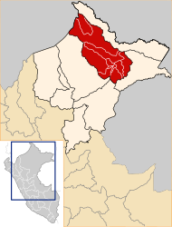
 The Punchana District is located in the central southeast of Maynas Province |
|
| Basic data | |
| Country | Peru |
| region | Loreto |
| province | Maynas |
| Seat | Punchana |
| surface | 1603 km² |
| Residents | 85,047 (2017) |
| density | 53 inhabitants per km² |
| founding | December 16, 1987 |
| ISO 3166-2 | PE-LOR |
| politics | |
| Alcaldesa district | Jane Adilia Donayre Chávez (2019-2022) |
| Political party | Movimiento Esperanza Región Amazónica |
Coordinates: 3 ° 44 ′ S , 73 ° 15 ′ W
The Punchana District is located in the Maynas Province in the Loreto Region in northeastern Peru . The district was established on December 16, 1987. The district has an area of 1603 km². At the 2017 census, there were 85,047 residents in the district. In 1993 the population was 52,794, in 2007 76,435. The administrative seat is the city of Punchana, 105 m high on the left bank of the Amazon , with 78,320 inhabitants (as of 2017). Punchana is a northern suburb of the provincial and regional capital Iquitos .
Geographical location
The Punchana District is located in the Peruvian Amazon in the central southeast of Maynas Province. It extends over the catchment area of the Río Momon, a left tributary of the Río Nanay , north of the Amazon.
The Punchana district is bordered by the Iquitos district to the south, the Alto Nanay district to the west, the Mazán district to the north and northeast, and the Indiana and Belén districts to the southeast .
Individual evidence
- ^ Peru: Loreto region - provinces and districts . www.citypopulation.de. Retrieved May 21, 2020.
