Napo District
| Napo District | |
|---|---|
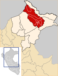
 The Napo District is located in the central north of Maynas Province |
|
| Basic data | |
| Country | Peru |
| region | Loreto |
| province | Maynas |
| Seat | Santa Clotilde |
| surface | 24,161 km² |
| Residents | 16,766 (2017) |
| density | 0.7 inhabitants per km² |
| founding | July 2, 1943 |
| ISO 3166-2 | PE-LOR |
| politics | |
| Alcalde District | Gil Blas Ruiz Rios (2019-2022) |
Coordinates: 2 ° 29 ′ S , 73 ° 41 ′ W
The Napo district is located in the Maynas Province in the Loreto region in northeastern Peru . The district was established on July 2, 1943. The district has an area of 24,161 km². At the 2017 census, there were 16,766 residents in the district. In 1993 the population was 12,110, in 2007 14,882. The administrative seat is the small town of Santa Clotilde, 100 m high on the right bank of the Río Napo , with 4011 inhabitants (as of 2017). Santa Clotilde is located 145 km north-northwest of the provincial and regional capital Iquitos .
Geographical location
The Napo District is located in the Peruvian Amazon in the central north of the Maynas Province. The Río Napo crosses the district in a south-easterly direction. The district includes the catchment areas of Río Tacsha Curaray, Río Curaray and Río Tamboryacu .
The Napo district borders in the southeast and in the south with the district Mazán , in the southwest with the districts Alto Nanay and Tigre , in the west with the Ecuador , in the northwest with the district Torres Causana , in the north with the district Rosa Panduro and in the northeast with the Putumayo District
Individual evidence
- ^ Peru: Loreto region - provinces and districts . www.citypopulation.de. Retrieved May 23, 2020.