Alto Nanay District
| Alto Nanay District | |
|---|---|
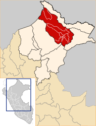
 The Alto Nanay District is located in the west of Maynas Province |
|
| Basic data | |
| Country | Peru |
| region | Loreto |
| province | Maynas |
| Seat | Santa Maria de Nanay |
| surface | 14,563 km² |
| Residents | 3082 (2017) |
| density | 0.2 inhabitants per km² |
| founding | July 2, 1943 |
| ISO 3166-2 | PE-LOR |
| politics | |
| Alcalde District | Carlos Yumbato Del Aguila (2019-2022) |
Coordinates: 3 ° 53 ′ S , 73 ° 42 ′ W
The Alto Nanay District is located in the Maynas Province in the Loreto Region in northeastern Peru . The district was established on July 2, 1943. It has an area of 14,563 km². The 2017 census counted 3,082 inhabitants. In 1993 the population was 2271, in 2007 it was 2617. The administrative center is the town of Santa María de Nanay with 738 inhabitants , located 128 m high on the left bank of the Río Nanay . Santa María de Nanay is located 50 km west-southwest of the provincial and regional capital Iquitos .
Geographical location
The Alto Nanay district is located in the Peruvian Amazon in the west of Maynas Province. It has a longitudinal extent in NNW-SSE direction of 240 km and a maximum width of about 85 km. The district extends over the upper catchment area of the Río Nanay, a left tributary of the Amazon . The Río Nanay and its left tributary Río Pintoyacu cross the area in a predominantly southeastern direction. The area consists mainly of rainforest.
The Alto Nanay district borders in the extreme southwest on the district Nauta ( province Loreto ), in the west on the district Tigre (also in the province Loreto), in the extreme north on the district Napo , in the northeast on the district Mazán , in the southeast on the Districts of Punchana and Iquitos and in the south to the district of San Juan Bautista .
Individual evidence
- ^ Peru: Loreto region - provinces and districts . www.citypopulation.de. Retrieved May 24, 2020.