
amazon basin

The catchment area of the Amazon , the Rio Anapu and the Rio Tocantins is referred to as the Amazon basin ( Portuguese Bacia do rio Amazonas ), Amazon lowland or Amazonia . It covers almost all of the northern half of the continent of South America . The Amazon has by far the largest water discharge in the world (see "Outflow" in List of the longest rivers on earth ).
This largest river plain in South America, an equatorial lowland rain forest, receives the water that forms it primarily from the Andes . The main direction of flow there initially points north and then changes across the entire continent to the east. To the north lies the Orinoco plain, separated by the Guiana mountains, but connecting the Amazon and Orinoco river systems via the Casiquiare . South lies the plain of the Río Paraguay and Paraná .
geography
The Amazon Basin lies in a triangle roughly circumscribed by the cities of La Paz , Quito , Belém (South, North, East). It includes territories in the states of Brazil , French Guiana , Suriname , Guyana , Venezuela , Colombia , Ecuador , Peru and Bolivia . With about 7 million km², which corresponds to about five percent of the total land area of the earth , it is the largest contiguous landscape area and thus also the second largest contiguous forest on our planet after the boreal coniferous forest .
The area describes a landscape that is shaped by the huge river system of the Amazon and thus also includes its more than 1000 "larger" tributaries. In addition, there are two rivers running parallel to the final section from the south (Rio Anapu and Tocantins). Most of the Amazon basin (about two-thirds of the area) belongs to Brazil. Not only is the Amazon a mighty river (more precisely stream ), but also many of its tributaries. Ten of them are among the twenty-five most water-rich rivers on earth, including even a tributary of a tributary, namely the Rio Branco . During the rainy season , large parts of the Amazon basin are flooded. In the meantime, numerous nature reserves have been designated in the Amazon basin, including the largest in Peru, which is also the second largest in the Amazon basin, Pacaya-Samiria .
river system

It is estimated that around one fifth of all fresh water on earth flows in the Amazon Basin. The basin has such a low gradient that the rivers usually only have a very low flow rate. For the Amazon, the gradient is around five centimeters per kilometer. Depending on the season, less than 100,000 or even more than 200,000 m³ of water per second are fed into the Atlantic Ocean . The major tributaries of the Amazon can be distinguished by their colors. The Rio Negro already indicates its color black (black water) in its name. The Rio Madeira is considered a yellow-red river, the Rio Tapajós and the Rio Xingu have clear water ( clear water ) that appears blue-green from a distance and from the plane. In general, the dark rivers ( black water rivers ) tend to flow in from the north (i.e. on the left), the light ones (mud or white water ) tend to flow in from the south (i.e. on the right). The reason lies in the soil conditions and thus the erosion of the regions through which the water flows or the source areas.
climate
There is only a humid tropical daytime climate in the Amazon basin, which means it is moderately hot all year round with humidity often exceeding 90%. The tropical jungle has an overall moderate effect on the climate, but due to the very high humidity, the climate is muggy and oppressive during the day.
There is copious rainfall almost daily, typically in the afternoon. The annual amount of precipitation is over 2000 millimeters in many places, which is two to three times the value achieved in Germany . These usually heavy rains also bring additional nutrients with them. They are contained in the dust that has often been kicked up thousands of kilometers away (e.g. the Sahara) and then carried with the wind to Amazonia. There it is sucked in by the huge tropical thunderstorms and returns to earth with the rain. The nutrients contained in the dust are then integrated into the nutrient cycle of the rainforest.
In the lowlands of the Amazon Basin, the average temperatures of the individual months of the year vary only very slightly between 25 °C and 28 °C, in somewhat higher areas the temperatures are correspondingly lower. The daily maximum temperatures in the jungle at low altitudes are mostly between 30 °C and 34 °C, while temperatures between 20 °C and 24 °C are often reached at night.

Iquitos , Peru

Manaus , Brazil

Belem , Brazil

Puyo , Ecuador
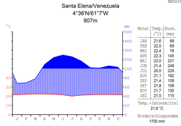
Santa Elena de Uairen , Venezuela

Santa Ana del Yacuma , Bolivia


Flora and fauna

In 2007, the rainforests of the Amazon region still covered an area of around 110 million hectares. Of these, around 22 million hectares (20 percent) were under state protection, around 23 million hectares (21 percent) were designated as indigenous settlement areas, and around 26.5 million hectares (24 percent) were privately owned – with some dubious proof of ownership , and 38.5 million hectares (35 percent) were “open to access,” that is, without an official zoning plan.
flora
The vegetation in Amazonia is very heterogeneous . A rough subdivision of the most widespread forms of vegetation includes: dense forests, open forests with palm trees, liana forests , dry forests , mountain forests (especially on the Andean slopes), flooded forests ( Várzea ), swamp forests ( Igapó ), with the non-flooded forest types collectively referred to as terra firme forest will. In addition, there are local formations such as mangrove forests , forest-free savannahs ( campos naturais ), caatinga , etc. Scientists have calculated that there are around 16,000 tree species in Amazonia, with half of all individual trees in the region only belonging to 227 species.
Terra preta is a fertile, anthropogenic black soil that is common near the Amazon and its tributaries.
fauna
The Amazon region is characterized, among other things, by its great biodiversity . The number of species actually found in the Amazon region is difficult to estimate, as only a fraction of them have been discovered and described. It is assumed that there are between five and ten million species. Of these, about 1.4 million have been described to date, including 750,000 insect species, 40,000 vertebrates, 250,000 plants and 360,000 microbiota. It is assumed that around a quarter of the living animal and plant species have their habitat in the region. The fish fauna is estimated at 2,000 species, more than all other rivers in the world combined.
population

About 22 million people live in the Amazon region. About a million of these belong to one of the diverse indigenous peoples in the region. In the Brazilian part of the Amazon region, 150 different indigenous peoples are distinguished, and some of the last so-called isolated peoples also live there .
Other important population groups are traditional riverside residents ( Ribeirinhos ), some of whom came to the region during the rubber boom and made a living from rubber tapping. Later, settlers ( colonos ) were added, who were allocated plots of land for arable farming as part of state settlement measures to develop the region. As a result, great tensions arose between the farmers and cattle breeders on the one hand, who endangered the rubber forests through large-scale clearing, and the Seringueiro movement on the other hand, which depended on these forests for their livelihoods. More people came to the region as part of industry and trade, most notably in Manaus through the establishment of a free trade zone .
politics
In 1978, the riparian states of the Amazon basin passed an agreement on cooperation in the Amazon region ( Tratado de Cooperación Amazonica , TCA). In 2003, this gave rise to the organization of the Amazon Pact ( OTCA ) based in Brasília .
Ecological problems
In the 1970s, the construction of large trunk roads began, and in the years that followed large-scale forest clearing by agrarian colonists and later by large landowners who raised cattle. In addition, the mining development of iron ore , tin , gold , petroleum and bauxite deposits led to further large-scale clearing of the tropical rainforest . This clearing continues to this day and has already led to ecological damage affecting flora and fauna.
Important cities
Cities in the Amazon region that are important for the infrastructure of the surrounding areas are:
See also
literature
- John Hemming: Tree of Rivers: The Story of the Amazon. [History of Amazonia, 1500–2006]. Thames & Hudson, 2009. ISBN 978-0-500-28820-7 (paperback). (2012 also as e-book: ISBN 978-0-500-77123-5 )
itemizations
- ↑ Nature 452, 2008, p. 134 f.
- ↑ H. ter Steege et al.: Hyperdominance in the Amazonian Tree Flora. In: Science , 2013; 342 (6156): 1243092 doi:10.1126/science.1243092
- ↑ The Brockhaus - In five volumes , vol. 1, 1993, p. 82.
web links
- Major projects in the Amazon basin. In: amazonwatch.org
- Amazon rainforest in danger: deforestation every second. In: Süddeutsche Zeitung . January 25, 2008.
- Consequence of deforestation - Amazon rainforest could become savannah. In: Mirror Online . February 6, 2008.
- Amazon website. In: amazonas.de