Purus Province
| Purus Province | |
|---|---|
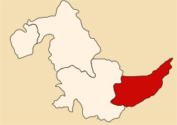
 Location of the province in the Ucayali region |
|
| Basic data | |
| Country | Peru |
| region | Ucayali |
| Seat | Puerto Esperanza |
| surface | 17,848 km² |
| Residents | 2860 (2017) |
| density | 0.2 inhabitants per km² |
| founding | July 2, 1943 |
| ISO 3166-2 | PE-UCA |
| politics | |
| Alcalde Provincial | Empty Panduro Pérez (2019-2022) |
| Political party | Peruanos Por el Kambio |
Coordinates: 9 ° 46 ′ S , 70 ° 43 ′ W
The province of Purús is located in the Ucayali region in eastern Peru . The province has an area of 17,848 km². At the 2017 census, 2,860 people lived in the province. In 1993, the population in 2532 was, in 2007 at the 3746th council is based in the northwest of the province of the river Río Purús location Puerto Esperanza . The Alto Purús National Park extends over a large part of the province.
Geographical location
The province of Purús is located in the southeast of the Ucayali region. It extends over the Amazon lowlands . It has a longitudinal extent in SW-NE direction of about 260 km. The upper reaches of the Río Purús ( Río Alto Purús ) flows through the province in a north-easterly direction and drains much of the province. Only the northeast of the province lies in the catchment area of the Rio Juruá .
The province of Purús borders Brazil to the north and east , the Tahuamanu province ( Madre de Dios region ) to the south and the Coronel Portillo province to the west .
Administrative division
The province of Purus consists of a single district: Purus .
Individual evidence
- ↑ a b Purus, province in the Ucayali region . www.citypopulation.de. Retrieved November 30, 2019.