Urubamba district
| Urubamba district | |
|---|---|
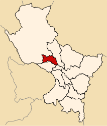
 The Urubamba District is centrally located in the Urubamba Province (marked in red) |
|
| Basic data | |
| Country | Peru |
| region | Cusco |
| province | Urubamba |
| Seat | Urubamba |
| surface | 161 km² |
| Residents | 22,406 (2017) |
| density | 139 inhabitants per km² |
| founding | June 21, 1825 |
| ISO 3166-2 | PE-CUS |
| Website | muniurubamba.gob.pe (Spanish) |
| politics | |
| Alcalde Provincial | Luis Alberto Valcárcel Villegas (2019-2022) |
| Political party | Acción Popular |
| The city of Urubamba | |
Coordinates: 13 ° 18 ′ S , 72 ° 7 ′ W
The Urubamba District is located in the Urubamba Province of the Cusco Region in south-central Peru . The district founded on June 21, 1825 has an area of 161 km². At the 2017 census, 22,406 people lived in the district. In 1993 the population was 13,692, in 2007 17,787. The district and provincial administration is located in the city of Urubamba with 13,942 inhabitants (as of 2017) at an altitude of 2869 m on the Río Urubamba . Urubamba is located 28 km north-northwest of the regional capital Cusco .
Geographical location
The Urubamba District is centrally located in the Urubamba Province. The Río Urubamba flows west along the southern district boundary. The glaciated Cordillera Urubamba runs along the northern district boundary .
The district of Urubamba borders in the south on the district of Maras , in the west on the district Ollantaytambo , in the north on the district Lares ( province Calca ), in the northeast on the district Calca (also in the province Calca) and in the southeast on the district Yucay .
Web links
- Municipalidad Provincial de Urubamba
- Peru: Region Cusco (provinces and districts) at www.citypopulation.de
- INEI Perú

