Machupicchu District
| Machupicchu District | |
|---|---|
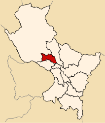
 The Machupicchu District is located in the northwest of the Urubamba Province (marked in red) |
|
| Basic data | |
| Country | Peru |
| region | Cusco |
| province | Urubamba |
| Seat | Machupicchu (Aguas Calientes) |
| surface | 361 km² |
| Residents | 5614 (2017) |
| density | 16 inhabitants per km² |
| founding | October 1, 1941 |
| ISO 3166-2 | PE-CUS |
| Website | munimachupicchu.gob.pe (Spanish) |
| politics | |
| Alcalde District | Darwin Baca León (2019-2022) |
| Political party | El Frente Amplio por Justicia, Vida y Libertad |
| Machupicchu (Aguas Calientes) | |
Coordinates: 13 ° 9 ′ S , 72 ° 32 ′ W
The Machupicchu district is located in the Urubamba province of the Cusco region in south-central Peru . The district founded on October 1, 1941, has an area of 361 km². At the 2017 census, there were 5,614 residents in the district. In 1993 the population was 2298, in 2007 it was 5286. The district administration is located in the small town of Machupicchu (Aguas Calientes) with 2060 inhabitants (as of 2017) at an altitude of 2848 m on the Río Urubamba . Machupicchu is located about 70 km west-northwest of the regional capital Cusco . Machu Picchu is an important Inca ruin near Machupicchu .
Geographical location
The Machupicchu district is located in the Andes in the northwest in the Urubamba province. The district is traversed by the Río Urubamba in a north-westerly direction. The district extends in the southwest to the 6,264 m high Salcantay , the highest point of the Cordillera Vilcabamba . The Cordillera Urubamba runs along the northern district boundary .
The Machupicchu district borders in the west on the district Santa Teresa ( province La Convención ), in the north on the district Huayopata (also in the province La Convención) and in the southeast on the district Ollantaytambo .
Web links
- Municipalidad Distrital de Machupicchu
- Peru: Region Cusco (provinces and districts) at www.citypopulation.de
- INEI Perú

