Urubamba Province
| Urubamba Province | |
|---|---|
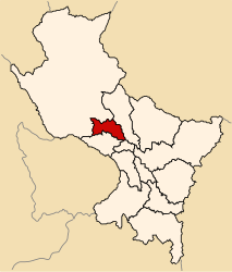
 Location of the province in the Cusco region |
|
| Basic data | |
| Country | Peru |
| region | Cusco |
| Seat | Urubamba |
| surface | 1,439.4 km² |
| Residents | 60,739 (2017) |
| density | 42 inhabitants per km² |
| founding | June 21, 1825 |
| ISO 3166-2 | PE-CUS |
| Website | muniurubamba.gob.pe (Spanish) |
| politics | |
| Alcalde Provincial | Luis Alberto Valcárcel Villegas (2019-2022) |
| Salt pans near Maras | |
Coordinates: 13 ° 15 ′ S , 72 ° 17 ′ W
The Urubamba Province is one of thirteen provinces in the Cusco Region in south-central Peru . It has an area of 1439.43 km². The 2017 census counted 60,739 inhabitants in the province. In 1993 the population was 48,254, in 2007 56,685. The provincial administration is located in the city of Urubamba .
Geographical location
The province of Urubamba is located in the Andes about 25 km northwest of the regional capital Cusco . The province extends along an approximately 75 km long section of the Río Urubamba , which crosses it in a west-northwest direction. The Cordillera Vilcabamba with the 6,264 m high Salcantay runs along the southwestern provincial border . A mountain ridge with the peaks Nevado Veronica ( 5683 m ) and Nudo Chicón ( 5515 m ) runs along the northern provincial border .
The province of Urubamba borders the province of Calca in the northeast, the province of Cusco in the southeast, the province of Anta in the south and the province of La Convención in the northwest .
Administrative division
The Urubamba Province is divided into seven districts. The Urubamba district is the seat of the provincial administration.
| District | Administrative headquarters |
|---|---|
| Chinchero | Chinchero |
| Huayllabamba | Huayllabamba |
| Machupicchu | Machupicchu |
| Maras | Maras |
| Ollantaytambo | Ollantaytambo |
| Urubamba | Urubamba |
| Yucay | Yucay |
Web links
- Peru: Region Cusco (provinces and districts) at www.citypopulation.de
- INEI Perú
