Huayllabamba District (Urubamba)
| Huayllabamba District | |
|---|---|
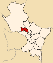
 The district of Huayllabamba is located in the east of the province of Urubamba (marked in red) |
|
| Basic data | |
| Country | Peru |
| region | Cusco |
| province | Urubamba |
| Seat | Huayllabamba |
| surface | 76.8 km² |
| Residents | 6012 (2017) |
| density | 78 inhabitants per km² |
| founding | January 2, 1857 |
| ISO 3166-2 | PE-CUS |
| politics | |
| Alcalde District | Amilcar Cusicuna Alvarez (2019-2022) |
Coordinates: 13 ° 20 ′ 17 ″ S , 72 ° 3 ′ 55 ″ W.
The Huayllabamba District is located in the Urubamba Province of the Cusco Region in south-central Peru . The district was founded on January 2, 1857. It has an area of 76.8 km². The 2017 census counted 6,012 inhabitants. In 1993 the population was 4736, in 2007 it was 4980. The district administration is located in the 2868 m high village of Huayllabamba with 1478 inhabitants (as of 2017). Huayllabamba is 7 km east-southeast of the provincial capital Urubamba and 22 km north-northwest of the regional capital Cusco .
Geographical location
The Huayllabamba district is located in the east of the Urubamba province. The Río Urubamba crosses the district in a westerly direction.
The district of Huayllabamba borders in the south with the district Chinchero , in the west with the district Maras , in the northwest with the district Yucay and in the northeast with the district Calca ( province Calca ).
Localities
In addition to the main town, the district has the following larger towns:
- Huayoccari Alto (238 inhabitants)
- Huayoccari Bajo (888 inhabitants)
- Huycho (641 inhabitants)
- Racchi Ayllu (697 inhabitants)
Web links
- Peru: Region Cusco (provinces and districts) at www.citypopulation.de
- INEI Perú
