Urubamba
|
Río Urubamba Río Vilcamayu, Río Vilcanota |
||
|
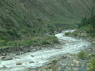
The valley of the Río Urubamba |
||
| Data | ||
| location |
|
|
| River system | Amazon | |
| Drain over | Río Ucayali → Amazon → Atlantic Ocean | |
| Headwaters | near the Andean pass Abra la Raya 14 ° 28 ′ 41 ″ S , 71 ° 0 ′ 6 ″ W |
|
| Source height | approx. 4300 m | |
| Confluence with |
Río Tambo to Río Ucayali Coordinates: 10 ° 42 ′ 3 ″ S , 73 ° 45 ′ 22 ″ W 10 ° 42 ′ 3 ″ S , 73 ° 45 ′ 22 ″ W. |
|
| Mouth height | approx. 210 m | |
| Height difference | approx. 4090 m | |
| Bottom slope | approx. 5.5 ‰ | |
| length | 750 km | |
| Catchment area | 60,300 km² | |
| Drain |
MQ |
2330 m³ / s |
| Left tributaries | Río Hercca , Río Santa Teresa, Río Vilcabamba , Río Cushireni, Río Cumpirosiato, Río Mantalo , Río Picha | |
| Right tributaries | Río Yanatile , Río Yavero , Río Yuyato , Río Ticumpinia , Río Timpia , Río Mishansha , Río Camisea , Río Inuya | |
| Medium-sized cities | Sicuani , quillabamba | |
| Small towns | Combapata , Písac , Calca , Urubamba , Ollantaytambo , Aguas Calientes , Santa Teresa | |
| Communities | Timpia, Camisea , Kirigueti, Sepahua | |
|
The Urubamba is the right source river of the Ucayali |
||
|
Urubamba |
||
|
Confluence of the Tambo (front) and Urubamba (right) to the Ucayali (to the left) |
||
|
Urubamba (view from the train to Machu Picchu) |
||
|
The villages in the Valle Sagrado along the Río Urubamba |
||
The Río Urubamba is the right source river of the Río Ucayali in eastern Peru .
It rises on the watershed between the southeastern Andean chains of Peru and the highlands ( Altiplano ) of Peru and Bolivia , near the Andes pass Abra la Raya northwest of Lake Titicaca .
River course
The Urubamba flows parallel to the east and north of the Río Apurímac through one of the most culturally and scenic areas of Peru, past numerous ruins of the Incas and older cultures (see also Valle Sagrado ).
After the village of Ollantaytambo , the Urubamba meanders through the deep gorges (e.g. Cañon Torontoy) towards the rainforest. At this point the ruined city of Machu Picchu is high up in the cloud forest . At the foothills of the Eastern Cordilleras, it then runs through a wide and fertile valley (fruit and tea cultivation) in the province of La Convención with the regional center of Quillabamba . Further west, the Urubamba river disappears into the rainforest , through the last foothills of the Andes and piercing them at the breakthrough valley " Pongo de Mainique ", past the natural gas sources of Camisea, before it joins the Río Tambo to the Río Ucayali at Atalaya .
Valle Sagrado
The Valle Sagrado ("Sacred Valley of the Inca", Quechua: Willka Qhichwa ) is the agriculturally most important high valley of the Incas. The area between the villages of Písac and Ollantaytambo , north of the city of Cusco , is called Valle Sagrado . This originally deep valley at the foot of the Schneeberg mountains was made wide by alluvial material (sometimes over 3 km) and thus forms fertile soil for arable farming (especially maize cultivation) to this day. In addition to the previously mentioned smaller towns of Písac and Ollantaytambo, there are other smaller settlements and the larger centers of Calca and Urubamba.
Use of hydropower
The Machupicchu and Santa Teresa hydropower plants are located on the Río Urubamba .
Surname
The Río Urubamba is also called Río Vilcanota ( Vilcomayo , Quechua : Willkamayu , "holy river") until the confluence of the Río Huatanay east of Cusco (near Caicay) . The name comes from Quechua and means something like "plane of the spiders" (which refers to the valley level; the river is called in its entire length in Quechua Willkamayu ).
The Urubamba in the film
The Río Urubamba is one of the rivers on which Werner Herzog shot the film Aguirre in 1971 , with which he depicts a Spanish expedition train in search of the golden land of Eldorado . Klaus Kinski appeared in the main role of Aguirre .
Duke Fitzcarraldo (also with Klaus Kinski as the main actor) and parts of his A Caring Son were filmed on the Río Urubamba.
The largest tributaries
The largest tributaries include (downstream):
- Río Yavero (right)
- Río Timpia (right)
- Río Mishansha (right)
- Río Camisea (right)
- Río Picha (left)
- Río Inuya (right)
Important towns on the river
(Order in flow direction)
- Sicuani
- Raqchi (ruin)
- Urcos
- Andahuaylillas
- Pikillaqta (ruin)
- Pisac (place and ruin)
- Calca
- Yucay
- Urubamba
- Ollantaytambo
- Llactapata (ruin)
- Aguas Calientes
- Machu Picchu (ruin)
- Santa Teresa
- Quillabamba
- Echarate
- Quellouno
- Atalaya
- Colonia Penal de Shepua
Movies
- Rivers of the World: Urubamba - The River of the Ancestors , Arte Documentation 2010
Web links
Individual evidence
- ^ A b Kümmerly + Frey Rand McNally : International Atlas . Published by Georg Westermann Verlag ISBN 3-07-508962-1


