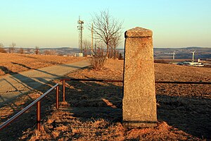
Dittersdorfer Höhe
| Dittersdorfer Höhe | ||
|---|---|---|
|
On the Dittersdorfer Höhe |
||
| height | 553.5 m | |
| location | Saxony ( Germany ) | |
| Mountains | Ore Mountains | |
| Coordinates | 50 ° 45 '46 " N , 13 ° 0' 32" E | |
|
|
||
| rock | Phyllite , quartzite | |
The Dittersdorfer Höhe is an elevation in the Saxon Ore Mountains northeast of the district of the same name Dittersdorf in the municipality of Amtsberg . On the ridge there is a station of the Royal Saxon Triangulation, built in 1869 .
geology
The surrounding rock is mainly made up of phyllitic rocks that can be traced as far as the Thum and Zwönitz area. Quartzite slate lenses, which were mined in the past for gravel extraction, are sheathed on the northern slope.
view
The Dittersdorfer Höhe is one of the most striking vantage points in the Lower Ore Mountains and offers the best view of the Lower Ore Mountains in the vicinity of Chemnitz . To the south the view extends to Jelení hora , Pöhlberg , Bärenstein , Klínovec , Fichtelberg and Scheibenberg, among others . The Augustusburg can be seen to the east, the Adelsberg to the north and the staircases near Sachsenburg in the distance . In addition, when visibility is good, the silhouette of the Lippendorf power station, which is just 65 km away, can be seen in a north-westerly direction . In a westerly direction the view extends into the Chemnitz basin .
Tourist development
Around 1900, an excursion restaurant was built to the south-west, below the plateau, which after several renovations and extensions now houses a hotel with a restaurant.
literature
- The middle Zschopau area (= values of our homeland . Volume 28). 1st edition. Akademie Verlag, Berlin 1977, pp. 149–150.
- Reinhart Heppner , Jörg Brückner , Helmut Schmidt: Saxon-Bohemian panoramic mountains of the western Ore Mountains in words and pictures. Geiger, Horb am Neckar 2000, ISBN 3-89570-593-4 , pp. 81-82.


