Dogger Bank


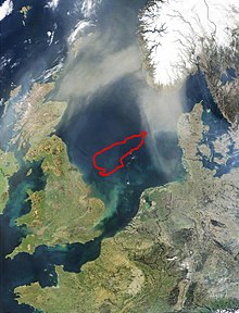
The Doggerbank (of mndl. Dogger for "fishing boat, esp. In the cod ") is a large, elongated, sometimes only about 13 meters below the sea level lying sand bench in the North Sea . It is considered the north-western boundary of the large German Bight . Part of the Doggerbank, which lies in the German exclusive economic zone, is designated as a nature reserve.
geography
location
The Doggerbank is located in the North Sea approximately between the English county of Yorkshire ( United Kingdom ), at the level of Middlesbrough , and the central part of the Jutland peninsula ( Denmark ), towards the Ringköbingfjord . The west end of the sandbank is around 100 kilometers from the British east coast, its east end around 125 to 150 kilometers from the Danish west coast.
expansion
The Doggerbank is between 300 and 350 kilometers long (in a west-east direction) and up to 120 kilometers wide. The area covers 17,600 square kilometers. It has an approximately teardrop-shaped shape, with the narrower end pointing towards Jutland.
Sea depth
While the North Sea has an average depth of 94 meters, the Dogger Bank is on average 30 meters deep. Its shallowest point (located between 54 and 55 degrees north latitude and between 1 and 2 degrees east longitude ) even measures only 13 meters.
history
Early days
The Doggerbank probably originated as a moraine formation in the Pleistocene . This happened north of the later mouth of the Ice Age Rhine , which at that time was clearly advanced to the north .
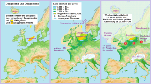
During the Ice Ages - when the sea level was up to 100 meters lower than it is today and the North Sea coast was about 600 kilometers north of its current position - the bank and the surrounding sea areas were dry and formed the Doggerland . The English Channel was also dry except for its western areas, so that there was a land connection between England and the mainland.
At the end of the last Ice Age, for example, sparse or boreal vegetation could develop on the transverse island bar, which was created because of the drop in sea level in the Dogger Bank area and on the English Channel . The lower lying areas between the two land connections on the Dogger Bank and the English Channel (today's southern North Sea) were filled with a freshwater lake .
As in the Mesolithic around 6500 BC BC the chalk cliff connection between the present-day cities of Dover and Calais was sufficiently eroded, the water of this freshwater lake could flow over the English Channel into the Atlantic. Subsequently, the sea level rose, so that the Dogger Bank and the English Channel were gradually flooded again and the water - as before the Ice Age and now - could flow from the Atlantic via the English Channel into the North Sea to flow along the Norwegian coast into the North Atlantic.
The Doggerbank was probably flooded by tsunamis as a result of the huge Storegga slide. The wave released by this slide of submarine rubble and debris rolled over the former Doggerland, which was only a few meters above sea level, with devastating consequences for the inhabitants of the time ( hunters and gatherers ).
Modern times
On August 5, 1781, during the Fourth Anglo-Dutch Sea War, the battle of the Dogger Bank broke out , and the outcome was a draw.
On the night of October 21-22, 1904, during the Doggerbank incident, British fishing boats were accidentally shot at over the Doggerbank by the Russian fleet , which they believed to be enemy torpedo boats on their way to the Russo-Japanese War .
On January 24, 1915, the battle between German and British battlecruisers took place here on the Dogger Bank . The naval battle ended with the sinking of the cruiser SMS Blücher and a tactical victory for the British squadron.
During the Second World War, the 1st Squadron of Kampfgeschwader 26 , with their Heinkel He 111 , mistakenly bombed the German destroyers Leberecht Maass , Max Schultz , Richard Beitzen , Theodor Riedel , Erich Koellner and Friedrich here on the night of February 22nd to 23rd, 1940 Eckoldt , who had left the Wikinger company . The captain of the boat, Korvettenkapitän Bassenge, was killed by three direct bomb hits on the Leberecht Maass . As a result of the attack, Leberecht Maass and Max Schultz got into a British mine lock and sank, leaving 590 dead.
During an overwater voyage in a storm, U-Hai sank in the Dogger Bank on September 14, 1966 to a depth of 40 meters. Only one of the 20 men was rescued.
Due to its shallow water depth ( sublittoral ), the Dogger Bank is protected as a "sand bank with only weak permanent overflow by sea water" by the fauna-flora-habitat directive of the European Union .
economy
Fishing
The Doggerbank is a good fishing area, especially for cod and plaice , which like to stay in the shallow water zones because of the warmer water.
Wind energy
Several countries are planning to open up a large area of the Doggerbank for wind energy use . There are plans to build large-scale wind turbines with a capacity of up to 100,000 megawatts in the sea area . This would be realized with an international distribution network.
For the distribution network, the transmission system operators Tennet TSO BV from the Netherlands, Tennet TSO GmbH from Germany, Energinet.dk from Denmark and Port of Rotterdam are planning wind energy distribution hubs in the North Sea under the name North Sea Wind Power Hub . One or more artificial islands ( Power Link Island ) are to be built up in the area of the Dogger Bank . Energy distribution crosses with interconnectors for the distribution of energy from the wind farms and generally between all the North Sea bordering states are to be built on it, as well as a central maintenance station for offshore wind farms . Among other things, the aim is to reduce costs and operate these wind farms more efficiently. For example, converter stations are to be built on the island, which would significantly reduce costs compared to converter platforms in the sea. In addition, spare parts and tools could be stored there in close proximity to the wind turbines and accommodation for service technicians could be created, so that less travel to and from the island would be necessary. For this was on March 23, 2017 agreement in the presence of EU Commissioner for Energy Union , Maroš Šefčovič , signed.
The UK government's plans to build the Dogger Bank offshore wind farm are further advanced than this project . The installation of around 1500 wind turbines with a total output of around nine gigawatts is planned, which would correspond to one of the largest offshore wind farms in the world. A further expansion to up to 13 gigawatts appears possible. The area is about 8600 square kilometers, with the water depth ranging from 20 to 60 meters.
See also
Web links
- The Dogger Bank: understanding stakeholder and policy-maker needs , article about the sandbank with a map showing the division of the bank into the respective exclusive economic zones (EEZ), on marine-vectors.eu (English)
Individual evidence
- ↑ M. Philippa, F. Debrabandere, A. Quak, T. Schoonheim and N. van der Sijs: dogger - (vissersschip). In: Etymologically Woordenboek van het Nederlands. 2003, accessed April 29, 2020 .
- ^ AH Stride: On the origin of the Dogger Bank, in the North Sea . In: Geological magazine . 96, No. 1, January 1959, pp. 33-34. Retrieved March 7, 2010.
- ↑ Bernhard Weninger (inter alia): The catastrophic final flooding of Doggerland by the Storegga Slide tsunami ( Memento from July 29, 2014 in the Internet Archive ) (PDF; 819.4 kB)
- ↑ Jürgen Rohwer , Gerhard Hümmelchen : Chronicle of the Sea War 1939–1945, February 1940. Retrieved on February 8, 2019 .
- ^ BfN : Sublitorale sandbanks. In: www.bfn.de. Archived from the original on June 24, 2016 ; accessed on June 24, 2016 .
- ↑ Huge electricity distribution network for wind power connects countries bordering the North Sea. iwr.de, March 9, 2017, accessed March 24, 2017 .
- ↑ SonneWind & Wärme, BVA Bielefelder Verlag, pp. 20 f, 41st year, ISSN 1861-2741
- ↑ Companies are planning an artificial island for wind power . in: Spiegel-Online , April 5, 2017, accessed April 5, 2017
- ^ Project Sheet. Retrieved February 24, 2020 .
- ^ Regional Investment Plan 2017 - North Sea. entso-e, accessed on February 24, 2020 .
- ↑ German companies build the world's largest wind farm , Tagesschau. June 4, 2010. Archived from the original on August 16, 2010. Retrieved on August 16, 2010.
- ↑ Wind power: Great Britain outstrips Germany . In: Berliner Morgenpost , January 8, 2010
Coordinates: 54 ° 43 ′ 29 ″ N , 2 ° 46 ′ 7 ″ E

