Dommartin (Ain)
| Dommartin | ||
|---|---|---|
|
|
||
| local community | Bâgé-Dommartin | |
| region | Auvergne-Rhône-Alpes | |
| Department | Ain | |
| Arrondissement | Bourg-en-Bresse | |
| Coordinates | 46 ° 20 ′ N , 4 ° 59 ′ E | |
| Post Code | 01380 | |
| Former INSEE code | 01144 | |
| Incorporation | 1st January 2018 | |
| status | Commune déléguée | |
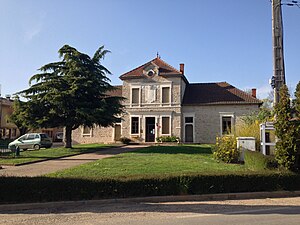
 Former town hall of Dommartin |
||
Dommartin is a former French community with 892 inhabitants (as of January 1 2017) in the department of Ain in the region Auvergne Rhône-Alpes . Administratively it was assigned to the arrondissement of Bourg-en-Bresse and the canton of Replonges (until 2015: canton of Bâgé-le-Châtel ). The inhabitants are called Dommartinais .
With effect from January 1, 2018, the formerly independent municipalities of Bâgé-la-Ville and Dommartin were merged to form the Commune nouvelle Bâgé-Dommartin and have the status of a Commune déléguée in the new municipality . The administrative headquarters are in Bâgé-la-Ville.
geography
Dommartin is located about twelve kilometers east-northeast of Mâcon in the Bresse countryside . The Loëze runs through the municipality . Dommartin is surrounded by the neighboring communities Boissey in the north, Marsonnas in the east, Saint-Sulpice in the south-east, Saint-Didier-d'Aussiat in the south and south-east, Bâgé-la-Ville in the south and west and Chevroux in the north-west.
Population development
| year | 1962 | 1968 | 1975 | 1982 | 1990 | 1999 | 2006 | 2013 |
| Residents | 671 | 598 | 528 | 517 | 537 | 600 | 756 | 882 |
| Source: Cassini and INSEE | ||||||||
Attractions
- La Pérouse fortified house from the 16th century
- Saint Blaise Church
