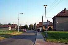
Drozdice
| Drozdice | ||||
|---|---|---|---|---|
|
||||
| Basic data | ||||
| State : |
|
|||
| Region : | Pardubický kraj | |||
| District : | Pardubice | |||
| Municipality : | Pardubice | |||
| Area : | 144 ha | |||
| Geographic location : | 50 ° 1 ′ N , 15 ° 49 ′ E | |||
| Height: | 230 m nm | |||
| Residents : | 92 (2011) | |||
| Postal code : | 530 02 | |||
| License plate : | E. | |||
| traffic | ||||
| Street: | Nemošice - Černá za Bory | |||
Drozdice (German Drozditz , 1939–45 Drostitz ) is a district of the town of Pardubice in Okres Pardubice in the Czech Republic . It is located four kilometers southeast of the city center of Pardubice and belongs to the Pardubice IV district .
geography
Drozdice is located on the right side of the Chrudimka on the river terrace Drozdická stráň in the Polabská rovina ( Elbe valley ). Immediately to the north is the Černá za Bory industrial area.
Neighboring towns are Studánka in the north, Černá za Bory in the north-east, Žižín and Mnětice in the east, Úhřetická Lhota , Úhřetice and Tuněchody in the south-east, Ostřešánky and Ostřešany in the south, Nemošice in the south-west, Jesničánky in the north and Pardubičky in the north.
history
The village was first mentioned in writing in 1492 as an accessory to the Nemošice fortress , when Jan Makovský and Jiří Voděradský sold them to Wilhelm von Pernstein . Wilhelm von Pernstein then struck the estate under his rule Pardubitz. In 1521 he bequeathed his Bohemian goods to his younger son Vojtěch , after his death in 1534 they passed to his brother Johann . In 1548 Johann von Pernstein left his son Jaroslav in debt. On March 21, 1560 Jaroslav von Pernstein sold the entire rule of Pardubitz to King Ferdinand I. His successor Maximilian II transferred the administration of the royal lords to the court chamber .
In 1835 the village of Drožditz , located in the Chrudim district , consisted of 17 houses in which 153 people lived. Parish was Pardubice. Until the middle of the 19th century Drožditz remained subordinate to the Imperial and Royal Chamber of Commerce Pardubice.
After the abolition of patrimonial Droždice formed from 1849 a municipality in the judicial district of Pardubice . From 1868 the village belonged to the Pardubice district . In 1869 Droždice had 137 inhabitants and consisted of 17 houses. In 1900, 117 people lived in Droždice , in 1910 there were 112. After the opening of the New Hospital in 1903, there was no space for a poor cemetery in the town of Pardubice. The city therefore bought a plot of land in the western part of the Droždice district above the Nemošická stráň. Drozdice has been used as a municipality name since 1924 . In 1930 the village consisted of 24 houses and had 135 inhabitants. In 1949 the community was assigned to the Okres Pardubice-okolí, since 1960 it has belonged again to the Okres Pardubice. On July 1, 1960 Drozdice was incorporated into Černá za Bory, since April 30, 1976 the village has belonged to Pardubice as a district. At the beginning of the 1970s, the Černá za Bory industrial area was built on the fields above Nemošická stráň, in which the state enterprise np Továrny mlýnských strojů - TMS Pardubice also built its new workshops. The former poor cemetery was bought and leveled by the TMS around 1970, in its place a parking and meeting place was to be created for the employees of the TMS. Between 1976 and 1978, in a second construction phase, in which a large foundry was also built, the TMS expanded its factory premises to the village of Drozdice. After the Velvet Revolution , the TMS was liquidated and most of the industrial area was assigned to the Černá za Bory cadastre. In the 2001 census, Drozdice consisted of 29 houses and had 85 inhabitants. At the beginning of 2019, 105 people lived in Drozdice.
Local division
The district Drozdice is divided into the basic settlement units Drozdice and Drozdice-průmyslový obvod.
Drozdice forms a cadastral district.
Attractions
- Memorial to the fallen of the First World War, on the village square
- Stone cross under a group of linden trees at the northern exit of the village
- Former poor cemetery, it was leveled by the TMS around 1970. The park-like area with tall trees is now located on company premises.
- Natural monument Nemošická stráň, the steep river terrace on the right bank of the Chrudimka, was placed under protection in 1982 on an area of 8.45 hectares.
literature
- Historický lexikon obcí České republiky 1869–2005 , part 1, p. 526
Web links
Individual evidence
- ↑ http://www.uir.cz/katastralni-uzemi/619973/Drozdice
- ^ Johann Gottfried Sommer : The Kingdom of Bohemia; Represented statistically and topographically. Volume 5: Chrudimer Kreis. Prague 1837, p. 53
- ↑ http://www.uir.cz/zsj-casti-obce/019976/Cast-obce-Drozdice
- ↑ http://www.uir.cz/katastralni-uzemi/619973/Drozdice


