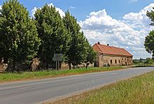
Druhanice
| Druhanice | ||||
|---|---|---|---|---|
|
||||
| Basic data | ||||
| State : |
|
|||
| Region : | Středočeský kraj | |||
| District : | Kutná Hora | |||
| Municipality : | Chotusice | |||
| Geographic location : | 49 ° 57 ' N , 15 ° 25' E | |||
| Height: | 220 m nm | |||
| Residents : | 8 (March 1, 2001) | |||
| Postal code : | 286 01 | |||
| License plate : | S. | |||
| traffic | ||||
| Street: | Čáslav - Žehušice | |||
Druhanice (German Druhanitz ) is a district of the municipality Chotusice in the Okres Kutná Hora in the Czech Republic . It is four kilometers north of Čáslav .
geography
Druhanice is located on the right side of the Brslenka brook in the Čáslavská kotlina ( Czaslau basin ). The road II / 338 between Čáslav and Chvaletice runs through the village . To the north is the Žehušická obora game reserve, and to the southwest is the Čáslav military airfield (LKCV). South of Druhanice, the Koudelovský potok flows into the Brslenka.
Neighboring towns are Žehušice and Borek in the north, Horka I , Svobodná Ves , Bojmany and Zaříčany in the northeast, Vlačice in the east, Dolní Bučice and Horní Bučice in the southeast, Vrcha and Čáslav in the south, Chotusice in the west and Rohozec in the northwest.
history
The first written mention of the fortress Drchanice took place in 1350. In 1490 there is evidence of a Kretscham in Druhanice. At that time the place belonged to the possessions of the city of Kuttenberg and later to the city of Čáslav. In 1533 the courtier Jan von Druhanice was slain with a sword in a dispute between Václav Žehušický from Nestajov on Žehušice. From 1643 Druhanice formed an independent estate. After 1661 Michael Oswald von Thun and Hohenstein on Žehušice acquired the Druhanice estate from Wenzel Wražda von Kunwald and united it with the Žehušice rule. In 1671 Michael Oswald von Thun determined the rule to become a majorate and bequeathed it to his brother Maximilian. During the First Silesian War , on May 17, 1742, the Prussian and Austrian armies clashed west of Druhanice in the Battle of Chotusitz .
In 1840 the village of Druhanitz or Druhanice , located on the Druhanitzer pond, consisted of 4 houses in which 21 people lived. There was a manorial farm and a mill in the village . The Druhanitzer pond was used by the rulers as a chamber pond. The parish was Chotusitz .
After the abolition of patrimonial Druhanice formed a district of the market town of Chotusice in the judicial district of Časlau . In 1850 Druhanice consisted of 3 houses and had 35 inhabitants. From 1868 the place belonged to the Časlau district .
Between 1952 and 1958, the Čáslav military airfield was established in the fields southwest of Druhanice - the battlefield of 1742. In the course of the territorial reform of 1960, the Okres Čáslav was repealed; Druhanice was assigned to the Okres Kutná Hora. In October 1991 the Austrian gardener Josef II Starkl took over the Druhanice estate, and his grandson Frank Starkl has been running the Starkl - zahradník spol since 2007. s ro
On March 3, 1991, the place had 18 residents; in the 2001 census there were 8 people living in the 4 houses in Druhanice, including 3 on the Žehušice part.
Local division
Druhanice is part of the Chotusice cadastral district, part of the village belongs to the Žehušice cadastral district.
Web links
Individual evidence
- ^ Johann Gottfried Sommer : The Kingdom of Bohemia; Represented statistically and topographically. Volume 11: Caslauer Kreis. Ehrlich, Prague 1843, p. 320 .
- ↑ https://centrum.starkl.com/historie/
- ↑ https://www.czso.cz/documents/10180/20565661/13810901.pdf/3fde2441-c81b-4a1e-9b94-551e65007f70?version=1.0


