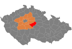
Okres Kutná Hora
| Okres Kutná Hora | |
|---|---|
| Kraj | Středočeský kraj |
| surface | 916.93 km² |
|
Inhabitants • Population density |
75,370 ( January 1, 2019 ) 80 inhabitants / km² |
|
Municipalities • of which cities • of which Městyse |
88 4 5 |
| LAU 1 | CZ0205 |
|
Vehicle registration number (issued until 2001) |
KH |

|
|
Okres Kutná Hora (German: Kuttenberg District ) is a district in the Czech Republic . It is located in the southeastern tip of the Středočeský kraj and in the north of the Bohemian-Moravian Highlands between the Sázava and Elbe rivers . The lowest point is in the north on the Klejnárka brook (198 m above sea level), the highest point is the Na Průhoně hill (551 m above sea level) near Třebětín .
On an area of 917 km² in 88 municipalities with 267 districts 73,600 inhabitants live, 53% of them in the four cities of Čáslav , Kutná Hora , Zruč nad Sázavou and Uhlířské Janovice . The majority of the population is now in the post-productive age.
Before the Second World War , pure agriculture was still predominant here. After that, more and more industrial companies settled here, mainly in the mechanical engineering, food industry, tobacco processing, glass, textile and shoe production sectors. The largest employers are in Zruč nad Sázavou (Sázavan), in Kutná Hora ( Avia , Philip Morris and ČKD) and in Čáslav (Praga). Nevertheless, there are most of the unemployed in the district: 11.9%. 49.6% of the population is employed, 28.4% in industry and 8.5% in agriculture. The average wage is 16,085 kroner , about 1000 kroner less than the district average.
Attractions
There are many historical monuments and buildings in the district.
- In Kutná Hora, the historical town center with the Cathedral of St. Barbara, the Church of St. Jacob and the Vlašský Dvůr is a UNESCO World Heritage Site .
- The Ursuline Monastery in Kutná Hora
- The Kačina castle , agricultural museum today
- Castle Žleby , built in 1278, and Castle Suchdol , Castle Tupadly , Castle Žehušice and castle Rataje .
Natural monuments include the park near the Žehušice chateau with coniferous and deciduous trees and fields where you can see white deer and fallow deer , the national natural monument Kaňk, a famous paleontological region and Rybníček u Hořan.
cities and communes
Adamov - Bernardov - Bile Podolí - Bludov - Bohdanečský - Brambory - Bratčice ( Bratschitz ) - Církvice - Čáslav - Čejkovice - Černíny - Červené Janovice - Čestín - Dobrovítov - Dolni Pohleď - Drobovice - Hlízov - HORKA I - Horka II - Horky - Horušice - Hostovlice - Hraběšín - Chabeřice - Chlístovice - Chotusice - Kácov - Kluky - Kobylnice - Kosice - Krchleby - Křesetice - Kutna Hora - Ledečko - Malešov - Miskovice - Močovice - Nepoměřice - Nové Dvory - Okřesaneč - Onomyšl - Opatovice I - Paběnice - Pertoltice - Petrovice I - Petrovice II - Podveky - Potěhy - Rašovice - Rataje nad Sázavou - Rohozec - Řendějov - Samopše - Semtěš - Schořov - Slavošov - Soběšín - Souňov - Staňkovice - Starkoč - Sudějov - Suchdol - Svaty Mikulas - Šebestěnice - Štipoklasy - Třebešice - Třebětín - Třebonín - Tupadly - Uhlířské Janovice - Úmonín - Úžice - Vavřinec - Vidice - Vinaře - Vlacice - Vlastějovice - Vlkaneč - Vodranty - Vrdy - Záboří nad Labem - Zbizuby - Zbraslavice - Zbýšov - Zruč nad Sázavou - Žáky - Žehušice - Žleby
Web links
Coordinates: 49 ° 52 ' N , 15 ° 14' E