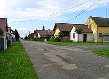
Horka I.
| Horka I. | ||||
|---|---|---|---|---|
|
||||
| Basic data | ||||
| State : |
|
|||
| Region : | Středočeský kraj | |||
| District : | Kutná Hora | |||
| Area : | 694 ha | |||
| Geographic location : | 49 ° 59 ' N , 15 ° 26' E | |||
| Height: | 211 m nm | |||
| Residents : | 406 (Jan. 1, 2019) | |||
| Postal code : | 286 01 | |||
| License plate : | S. | |||
| traffic | ||||
| Street: | Horušice - Vlačice | |||
| structure | ||||
| Status: | local community | |||
| Districts: | 3 | |||
| administration | ||||
| Mayor : | Miroslav Doležal (as of 2017) | |||
| Address: | Horka I 48 28601 Čáslav |
|||
| Municipality number: | 531430 | |||
| Website : | www.horka1.cz | |||
Horka I , also Horka u Žehušic (German Horka ) is a municipality in the Czech Republic . It is located nine kilometers northeast of the town of Čáslav in the Doubrava river plain and belongs to the Okres Kutná Hora .
geography
Horka I is located on the right side of the Čertovka brook at the western foot of the Iron Mountains ( Železné hory ) in the Čáslavská kotlina ( Czaslau basin ). The Žehušická obora game reserve is located south of the village.
Neighboring towns are Horušice , Zbraněves and Katovna in the north, Morašice , Hajný and Podlesí in the northeast, Svobodná Ves in the east, Zaříčany in the southeast, Bojmany in the south, Žehušice in the southwest, Borek in the west and Habrkovice, Lišice and Sulovice in the northwest.
history
Horka was first mentioned in a document in 1318. At that time the village was located southeast of its current location on the site of the Svobodná Ves farm. After its destruction in the Thirty Years' War , Horka was rebuilt in its current location by the Žehušice rulers. Between 1706 and 1791 Horka grew to 39 houses. In 1823 school lessons began in Horka.
In 1840 Horkau or Horka consisted of 39 houses in which 262 people lived. There was a school and a stately hunter's house in the village. The parish was Chotusitz .
After the abolition of patrimonial formed Žehušická Horka in 1849 with the districts Borek and Josefov t. Svobodná Ves is a municipality in the judicial district of Časlau . From 1868 the municipality belonged to the Časlau district . In 1869 Žehušická Horka reached the highest population in its history with 300 inhabitants. The official place name was changed to Horka / Horkow in the 1870s .
In the course of the territorial reform of 1960, the Okres Čáslav was repealed; Horka was assigned to the Okres Kutná Hora and was given the official name Horka I to distinguish it from a community of the same name . From 1961 to 1990 Horka I was incorporated into Žehušice. The school closed in 1976. After a referendum, the municipality of Horka I was established in November 1990.
Community structure
The municipality Horka I consists of the districts Borek ( Franzdorf ), Horka I and Svobodná Ves ( Josefsdorf ). The district Svobodná Ves is divided into the localities Josefov, Podlesí and Ovčíny as well as the layers Hajný ( Heger ) and Vinice ( Kiebl , formerly Winice ).
The municipality forms the cadastral district Horka u Žehušic .
Web links
Individual evidence
- ↑ a b http://www.uir.cz/katastralni-uzemi/795763/Horka-u-Zehusic
- ↑ Český statistický úřad - The population of the Czech municipalities as of January 1, 2019 (PDF; 7.4 MiB)
- ^ Johann Gottfried Sommer : The Kingdom of Bohemia; Represented statistically and topographically. Volume 11: Caslauer Kreis. Ehrlich, Prague 1843, p. 319 .
- ↑ http://www.uir.cz/casti-obce-obec/531430/Obec-Horka-I


