Železné hory
Coordinates: 49 ° 50 ' N , 15 ° 40' E

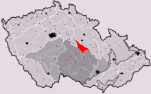
The Železné hory (German Iron Mountains ) are a mountain range in the Czech Republic and form part of the Bohemian-Moravian Highlands .
geography
The mountain range joins the Saar Mountains ( Žďárské vrchy ) in the northwest and extends from northwest to southeast. To the north it merges into the Chrudimská tabule ( Chrudimská tabule ), to the south the mountainous region of the upper Sázava ( Hornosázavská pahorkatina ) joins. The valley of the Doubrava forms the conclusion to the south . The mountains are located south of Pardubice within the urban triangle Čáslav - Chrudim - Hlinsko and cover an area of 748 km². It consists of two sub-units, the Chwaletitz hill country ( Chvaletická pahorkatina ) and the Setscher hill country ( Sečská vrchovina ).
The wooded ridge is cut through by the Chrudimka in a deep valley. The highest point is the Pešava (697 m), Hlinecké Kopce, Vestec and Hradiště are also significant. The lowest point is at Slatiňany at 268 m .
In the iron mountains are u. a. the Castle Lichtenburg ( Hrad Lichnice ) that seč dam , the stone sea at Krkanka, the gorges of Pekelský and Lovětínský Potok and the memorial Ležáky .
history
In the Iron Mountains in the 2nd and 1st centuries BC there was A Celtic settlement. At the transition from the 12th to the 13th century, the mountain range was colonized, and from 1288 onwards it was also known as "Mons ferrens" because of its iron ore mining. Old trade connections between Bohemia and Moravia have led through the mountains since the 10th century.
In the 18th century, Johann Adam von Auersperg built the Slavická game reserve in the Chrudim gorge Strádovské Peklo, where deer and mouflon have been kept ever since. In 1991 parts of the mountains were declared a landscape protection area.
geology

The Iron Mountains belong to the Bohemian Massif and are known as "Železnohorský Pluton", also "Nasavrcký masiv" (see: Pluton ). It has an area of about two hundred square kilometers and is enclosed by the Bohemian Chalk Basin from the northwest in an easterly direction to its southeastern flanks . In the mountains mainly granites and granodiorites occur. Large areas are formed by the Skuteč granite type , a fine to medium-grained rock with partly gray and partly crimson color. Occasionally small deposits of diorite and gabbros occur. At Prachovice , Vápenný Podol and Závratec limestone was mined for lime production on the western edge of the Iron Mountains .
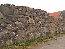
The deposits have been used intensively as a source of raw materials over the past two hundred years. There are numerous quarries that are used to manufacture stone products , paving stones and gravel . Visible evidence of the very old stone extraction are isolated walls made of reading stones in village areas , which can be up to about 0.5 cubic meters in size.
Geological exploration
The beginning of geological exploration work goes back to Franz Xaver M. Zippe , who provided an early description of the conditions with his publications from 1837 and 1843 ( Sommers's Topographie, Vol. V and XI ).
Ferdinand von Andrian carried out further field work in the years 1861–62. Around 1875 Jan Krejčí and Rudolf Helmhacker carried out extensive exploratory work in the Eisengebirge area and published their research results in a detailed text section on the geological map of this area. Her cartographic work remained unpublished.
After the Second World War , other important partial works (J. Vachtl 1955, 1957) were carried out in the region. Under the direction of M. Opletal, the entire area was extensively revised between 1965 and 1988 by numerous employees of the Geological Institute (Prague). In the years 1989, 1996, 1998, 1999 current map sheets were published.
Folklore
The Vysočina Open-Air Museum provides information about the life of the population in the Iron Mountains, especially the living conditions in the period from the middle of the 19th century to the middle of the 20th century .
Web links
Individual evidence
- ↑ Czech feminine
- ^ Ivo Chlupáč et al .: Geologická minulost České Republiky . Praha (Academia) 2002. pp. 203-204 ISBN 80-200-0914-0

