
Slatiňany
| Slatiňany | |||||
|---|---|---|---|---|---|
|
|||||
| Basic data | |||||
| State : |
|
||||
| Region : | Pardubický kraj | ||||
| District : | Chrudim | ||||
| Area : | 1560.5 ha | ||||
| Geographic location : | 49 ° 55 ' N , 15 ° 49' E | ||||
| Height: | 268 m nm | ||||
| Residents : | 4,187 (Jan 1, 2019) | ||||
| Postal code : | 538 21 | ||||
| License plate : | S. | ||||
| traffic | |||||
| Street: | Chrudim - Nasavrky | ||||
| Railway connection: | Havlíčkův Brod – Pardubice | ||||
| structure | |||||
| Status: | city | ||||
| Districts: | 5 | ||||
| administration | |||||
| Mayor : | Ivan Jeník (as of 2017) | ||||
| Address: | TG Masaryka 36 538 21 Slatiňany |
||||
| Municipality number: | 572268 | ||||
| Website : | www.slatinany.cz | ||||


Slatiňany (German Slatinian , older Schibran ) is a small Czech town on the Chrudimka in the Okres Chrudim with about 4000 inhabitants.
geography
The Silnice I / 37 runs through Slatiňany between Chrudim and Nasavrky . The town lies on the Havlíčkův Brod – Pardubice railway line .
history
Slatiňany was mentioned for the first time in 1294 and first belonged to a local nobleman, then from 1525 to 1547 the town of Chrudim . After changing owners, it was the seat of the Auersperg family from 1747 to 1942 . In 1911 Slatiňany received town charter.
City structure
The town of Slatiňany is divided into the districts
- Kochánovice (German: Kochanowitz )
- Kunčí (German: Kuntschi )
- Škrovád (German: Skrowad , older also Skowroda )
- Slatiňany
- Trpišov (German: Terpischau )
Basic settlement units are Kunčí, Škrovád, Slatiňany and Trpišov.
The municipality is divided into the cadastral districts of Kunčí, Škrovád, Slatiňany and Trpišov.
Attractions
- Slatiňany Castle
- The Slatiňany Stud , where around 250 Kladruber horses are kept, is part of the Kladruby nad Labem National Stud .
- Roman Catholic parish church of St. Martin from the 14th century
- The Vrchlický hill was a favorite place of the poet Jaroslav Vrchlický
- Na Chlumu observation tower

Slatiňany Castle

Slatiňany stud

Old Kladruber black horses
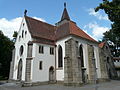
Martinskirche

Observation tower


Sons and daughters of the church
- Franz Schmoranz the Younger , also František Schmoranz, (1845-1892), Bohemian architect and founding director of the Prague School of Applied Arts
- Gustav Schmoranz (1858–1930), writer and director of the National Theater
- Jan Schmoranz (1857–1899), Bohemian architect
- Josef Schmoranz (1855–1938), Czech painter, curator and university professor
Web links
Individual evidence
- ↑ http://www.uir.cz/obec/572268/Slatinany
- ↑ Český statistický úřad - The population of the Czech municipalities as of January 1, 2019 (PDF; 7.4 MiB)
- ↑ http://digitool.is.cuni.cz:1801/view/action/nmets.do?DOCCHOICE=1026743.xml&dvs=1394968817800~538&locale=de_DE&search_terms=&adjacency=&VIEWER_URL=/view/action/nLEmets.do ? . & 3 & divType = & COPYRIGHTS_DISPLAY_FILE = license_mapy
- ↑ http://www.uir.cz/casti-obce-obec/572268/Obec-Slatinany
- ↑ Antonín Profous : Místní jména v Čechách - Vznik jejich, původní význam a změny .
- ↑ http://www.uir.cz/zsj-obec/572268/Obec-Slatinany
- ↑ http://www.uir.cz/katastralni-uzemi-obec/572268/Obec-Slatinany