Rozhovice
| Rozhovice | ||||
|---|---|---|---|---|
|
||||
| Basic data | ||||
| State : |
|
|||
| Region : | Pardubický kraj | |||
| District : | Chrudim | |||
| Area : | 471 ha | |||
| Geographic location : | 49 ° 58 ' N , 15 ° 43' E | |||
| Height: | 259 m nm | |||
| Residents : | 278 (Jan 1, 2019) | |||
| Postal code : | 538 03 | |||
| License plate : | E. | |||
| traffic | ||||
| Street: | Bylany - Choltice | |||
| Railway connection: | Heřmanův Městec – Borohrádek | |||
| structure | ||||
| Status: | local community | |||
| Districts: | 1 | |||
| administration | ||||
| Mayor : | Milan Stejskal (as of 2018) | |||
| Address: | Rozhovice 46 538 03 Heřmanův Městec |
|||
| Municipality number: | 547808 | |||
| Website : | www.rozhovice.cz | |||
Rozhovice (German Roshowitz , also Rozhowitz ) is a municipality in the Czech Republic . It is located four kilometers northeast of Heřmanův Městec and belongs to the Okres Chrudim .
geography
Rozhovice is located by the Dubanka brook on the Heřmanoměstecká tabule ( Hermannstädtler Tafel ). The Heřmanův Městec – Borohrádek railway runs on the northern outskirts, and the state road I / 17 between Chrudim and Heřmanův Městec is two kilometers south .
Neighboring towns are Čepí in the north, Dřenice in the Northeast, Třibřichy the east, Markovice and Bylany the southeast, Lány , Mlyn Prachovna, Morašice , Březina and Chotěnice in the south, Chotěnická Dubina, Novy Dvur, Nová Doubrava and Doubrava in the southwest, Klešice and Svinčany in West and Jeníkovice and Jezbořice in the north-west.
history
The first written mention of the parish village Rozhovice took place in 1131. Rozhovice used to be a separate landed estate, which was later united with the Heřmanův Městec estate. Between 1597 and 1645 the Doubrava settlement was established. Johann von Sporck had the church rebuilt. Further landlords after the Counts of Sporck were the Barons von Greiffenclau from 1798 and the Princes Kinsky from 1828 .
In 1835 the village of Rozhowitz , located in the Chrudim district , consisted of 14 houses in which 183 people lived. In the place there was the branch church to the apostles St. Peter and Paul as well as a Meierhof. The one-layer Alt-Daubrawa ( Doubrava ), consisting of four houses and a windmill, was consolidated at Rozhowitz . The parish was Heřmanmiestetz . Until the middle of the 19th century Rozhowitz remained subject to the allodial rule of Heřmanmiestetz.
After the abolition of patrimonial Rozhovice formed from 1849 with the district Doubrava a municipality in the judicial district of Chrudim . From 1868 the municipality belonged to the political district of Chrudim . Between 1897 and 1899 the railway line Heřmanův Městec – Borohrádek was laid.
At the beginning of 1976 Rozhovice was incorporated into Heřmanův Městec . Rozhovice has existed again since August 31, 1990.
Community structure
No districts are shown for the municipality of Rozhovice. The Doubrava ( Old Daubrawa ) residential area belongs to Rozhovice .
Attractions
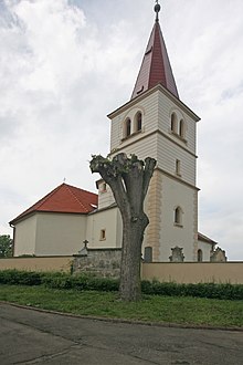
- Church of St. Peter and Paul, the church laid out in the first half of the 12th century was fundamentally redesigned and expanded in the second half of the 17th century. The baroque onion roof of the church tower was later removed. A general renovation took place between 2002 and 2005. Between 1969 and 1979 the painter Vojmír Vokolek created a large modern fresco on an interior wall, which is supposed to represent the physical and spiritual famine of mankind.
- Memorial stone for the fallen of the First World War
Individual evidence
- ↑ http://www.uir.cz/obec/547808/Rozhovice
- ↑ Český statistický úřad - The population of the Czech municipalities as of January 1, 2019 (PDF; 7.4 MiB)
- ^ Johann Gottfried Sommer : The Kingdom of Bohemia; Represented statistically and topographically. Volume 5: Chrudimer Kreis. Prague 1837, p. 23


