Ostrov u Chroustovic
| Ostrov | ||||
|---|---|---|---|---|
|
||||
| Basic data | ||||
| State : |
|
|||
| Region : | Pardubický kraj | |||
| District : | Chrudim | |||
| Area : | 418 ha | |||
| Geographic location : | 49 ° 58 ' N , 16 ° 2' E | |||
| Height: | 262 m nm | |||
| Residents : | 205 (Jan. 1, 2019) | |||
| Postal code : | 538 63 | |||
| License plate : | E. | |||
| traffic | ||||
| Street: | Hrochův Týnec - Zámrsk | |||
| structure | ||||
| Status: | local community | |||
| Districts: | 1 | |||
| administration | ||||
| Mayor : | Pavel Malý (as of 2018) | |||
| Address: | Ostrov 57 538 63 Chroustovice |
|||
| Municipality number: | 574104 | |||
| Website : | www.obec-ostrov.cz | |||
Ostrov (German Wostrow , 1939–45 Wostrau ) is a municipality in the Czech Republic . It is located nine kilometers northwest of Vysoké Mýto and belongs to the Okres Chrudim .
geography
Ostrov is located between the rivers Loučná and Novohradka on the Hrochotýnecká tabule ( Hrochow-Teinitzer Tafel ); the village itself is traversed by the Ostrovský creek. The state road I / 17 between Hrochův Týnec and Zámrsk runs through Ostrov . The Česká Třebová – Praha railway line runs north of the village .
Neighboring towns are Trusnov and Opočno in the north, Sedlíšťka and Radhošť in the north-east, Stradouň in the east, Vinary , Bětník and Mravín in the south-east, Mentour, Poděčely and Beziny in the south, Chroustovice and Holešovice in the south-west, Městec in the west and Turov in the north-west.
history
Finds of cremation graves from the Lusatian culture show that the area was settled at an early age.
Ostrov was first mentioned in documents in 1318 as the seat of Řehněř and Pešek von Ostrov. The subsequent owners of the Ostrov water fortress were Bohuněk von Ostrov in 1395 and Jan Talafús von Ostrov around 1439. In 1493 the Ostrov estate became extinct and was incorporated into the Košumberk domain . Ostrov later became part of the Chroustovice estate . In 1783 the landlord, Count Philipp Kinsky , had a school built in Ostrov.
In 1835, the village of Wostrow , located in the Chrudim district on Chrudim Poststrasse near the ponds Kovárný and Pěchaček, comprised 53 houses in which 296 people, including 11 Protestant families, lived. There was a school, a Meierhof, a pheasant garden with a hunter's house and a retreat in the village. The Catholic parish was Chraustowitz . Until the middle of the 19th century, Wostrow remained subordinate to the allodial rule of Chraustowitz.
After the abolition of patrimonial Vostrov formed a community in the judicial district of Hohenmauth from 1849 . From 1868 the community belonged to the political district Hohenmauth . In 1869 Vostrov had 353 inhabitants and consisted of 56 houses. Ostrov has been used as a place name since the beginning of the 20th century .
In 1900 there were 355 people in Ostrov, in 1910 there were 373. In 1930 the village had 322 inhabitants. Since 1961 the community belongs to Okres Chrudim. On July 1, 1985 Ostrov was incorporated into Stradouň . The Ostrov municipality has existed again since the beginning of 1992. At the 2001 census, there were 181 people in Ostrov's 69 houses.
Community structure
No districts are shown for the municipality of Ostrov.
Attractions
- Atonement cross on the village square, the age of the double cross is estimated to be around 900 years
- Bell tower
- Desert water festival at the upper pond on the southeastern edge of the village, nothing of the probably wooden structure is visible. Old horseshoes and a broken relief depicting the killing of the dragon by St. George and probably comes from a harness.
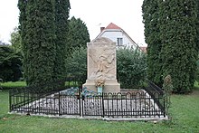
- Memorial stone for the fallen of the First World War
Sons and daughters of the church
- Jan Talafús von Ostrov (around 1410–1475), captain of the Bratříci, he was one of the most important military leaders of the post-Hussite period, his personality was processed several times in literary terms
literature
- Historický lexikon obcí České republiky 1869–2005 , part 1, p. 510
Web links
Individual evidence
- ↑ http://www.uir.cz/obec/574104/Ostrov
- ↑ Český statistický úřad - The population of the Czech municipalities as of January 1, 2019 (PDF; 7.4 MiB)
- ^ Johann Gottfried Sommer : The Kingdom of Bohemia; Represented statistically and topographically. Volume 5: Chrudimer Kreis. Prague 1837, p. 109


