Předhradí
| Předhradí | ||||
|---|---|---|---|---|
|
||||
| Basic data | ||||
| State : |
|
|||
| Region : | Pardubický kraj | |||
| District : | Chrudim | |||
| Area : | 833 ha | |||
| Geographic location : | 49 ° 50 ' N , 16 ° 2' E | |||
| Height: | 420 m nm | |||
| Residents : | 421 (Jan 1, 2019) | |||
| Postal code : | 539 73 - 539 74 | |||
| License plate : | E. | |||
| traffic | ||||
| Street: | Skuteč - Svratka | |||
| Railway connection: | Svitavy – Žďárec u Skutče | |||
| structure | ||||
| Status: | local community | |||
| Districts: | 2 | |||
| administration | ||||
| Mayor : | Zdeněk Mikšovský (as of 2018) | |||
| Address: | Kpt.Svatoně 80 539 74 Předhradí |
|||
| Municipality number: | 572101 | |||
| Website : | www.predhradi.cz | |||
Předhradí , until 1950 Rychmburk , (German Richenburg , older Reichenburg ) is a municipality in the Czech Republic . It is located four kilometers southeast of Skuteč on the Krounka and belongs to the Okres Chrudim . The historic town center has been protected as an urban monument zone since 1990.
geography
Předhradí lies on the left side on a ridge above the Šilinkovo údolí formed by the Krounka ( Richenburger Bach ) in the Skutečská pahorkatina ( Skutscher hill country ), on the western edge of the village the Lešanský potok flows. In the north of the municipality, Rychmburk Castle is enthroned on the spur above the confluence of the two streams . The state road II / 354 between Skuteč and Svratka leads through the village , from which the II / 358 branches off to Litomyšl southeast of Předhradí . The Svitavy – Žďárec u Skutče railway runs one and a half kilometers to the southwest, and the Předhradí stop is located in the Dolívka district. The Lešanský potok is dammed in the Spálívec pond on the southwestern edge of the village.
Neighboring towns are Lhota u Skutče and Zhoř in the north, Borek and Hluboká in the northeast, Hněvětice in the east, Kutřín in the southeast, Miřetín and Lešany in the south, Daletice and Dolívka in the southwest, Lažany in the west and Zbožnov in the northwest.
history
After John of Bohemia granted the area of Skuteč from royal possession to Tas von Mrdice, he had Reichenberg Castle built as the center of his rule in 1325 . In the course of time the name of the castle changed to Richenburg or Rychmburk. In the middle of the 14th century the lords of Pardubitz became owners of Richenburg. From 1390 Smil Flaška von Pardubitz lived in the castle. During the Hussite Wars, the Richenburg dominion remained one of the few bases of Catholicism in Eastern Bohemia. Between 1530 and 1540 the castle was rebuilt under the von Waldstein family . From the middle of the 17th century, the Berka von Dubá owned Richenburg until 1700. They were followed by the Kinsky .
The brewery was founded in 1636. In front of the castle there was still the manor house with a distillery and gradually a settlement developed around the farm buildings. The village of Předhrady was first mentioned in 1654 . The names Podhrady and Radině can also be found in older scripts . The castle was given up as a manor in 1714 and fell into disrepair. In 1737, Stephan Wilhelm Kinsky donated a palace chapel with a pastoral care station, which was raised to parish administration after the new church was completed; previously the place was parish after Skutsch . Under Philipp Joseph Kinsky there was a baroque reconstruction of the main building of the castle between 1793 and 1798; a manorial apartment as well as offices and officials' apartments were set up. In 1823 Karl Alexander von Thurn und Taxis acquired the rule. In dry years there was often a lack of water in Richenburg . The water for the brewery and two pipe boxes came from the south-west via a 682 fathom long pipeline from the Spálívec pond, which for the Meierhof was brought in from the south via another wooden water pipe from the Dniak pond near the Wochoska sheep farm. There was also a draw well.
In 1835 the market town of Richenburg in the Chrudim district consisted of 90 houses in which 575 people lived. The partly higher village was separated from the castle by a rocky ravine and connected with a stone bridge. The Church of the Seven Sorrows of Mary and the school were under stately patronage; the parish was occupied by a parish administrator and a cooperator paid from the religious fund. There was also a stately civil servants' residence in the village, the office building with part of the offices, a large stately farmyard, a bulk floor, a walled pleasure garden with fruit and mulberry plantations as well as greenhouses and pineapple houses, a stately brewery on 38 barrels, a malt kiln, three Grinding mills and an oil mill on the Richenburger Bach, a treadmill with ox drive, an inn and another tavern on the road to Skutsch. The sheep farm Wochoska, located south of the market, belonged to the Meierhof. The market had the privilege of having four annual fairs selling livestock, cut goods, pottery, household appliances and victuals. The coat of arms of the market showed the Richenburg with the inscription Pecžet Richty Pržedhradske . Richenburg was the parish for Hniewietitz , Borek , Kutřin , Peraletz , Leschan , Miřetin , Zhoř , Brdo , Rwasitz , Hlubočitz , Chlum , Rabaun and Stržitetz . Until the middle of the 19th century, the market town of Richenburg was the official place of the rule of the same name .
After the abolition of patrimonial formed Rychmburk / Richburg in 1849 with the districts Dolívka , Lažany and Lesany a town in the judicial district Skutsch . From 1868 the community belonged to the political district Hohenmauth . In 1869 Rychmburk had 566 inhabitants and consisted of 95 houses. In 1897 the Polička – Skutsch railway was built. In 1900 there were 667 people in Rychmburk, compared to 624 in 1910. Lažany and Lešany broke away from Rychmburk in 1925 and formed their own communities. In 1925 the brewery stopped producing its own beer and was used as the defeat of the Chrudimer brewery until 1930 . The brewery facilities were then dismantled. In 1930 Rychmburk had 482 inhabitants. In 1949 the community was assigned to the newly formed Okres Hlinsko. In 1950 the place was renamed in Předhradí. Since 1961 Předhradí belongs to the Okres Chrudim. At the beginning of 1986 it was incorporated into Skuteč. On August 31, 1990, Dolívka and Předhradí broke away from Skuteč and formed the municipality of Předhradí. In 1998 Předhradí won the village of the year competition in the Czech Republic. In the 2001 census, 446 people lived in Předhradí's 126 houses.
Community structure
The municipality Předhradí consists of the districts Dolívka ( Doliwka ) and Předhradí ( Richenburg ). Předhradí to also include the court Daletice ( Daletitz ), the deserted village Bezděč ( Bezdietitz ) and the monolayer Ochozka ( Wochoska ). The basic settlement unit is Předhradí.
The municipality forms the cadastral district Předhradí u Skutče.
Attractions
- Rychmburk Castle , built in 1325
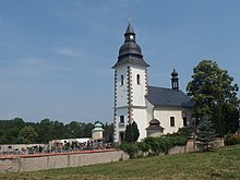
- Church of the Seven Sorrows of Mary, it was built in 1752–1753 under Philipp Graf Kinsky. The tower was added in 1816.
- Old brewery
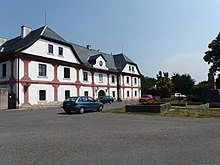
- Manor from the 17th century, built under the Berka von Dubá family
- Walled pleasure garden from the 18th century, with arbor and bust of the founder Philipp Joseph Count Kinsky
- Statue of Judas Thaddäus, erected in 1723
- Stone arch bridge over the Krounka
- Šilinkovo údolí the Krounka
- Chapel of St. Josef, foster father of the Lord, on the road to Lažany
- Group of statues of the crucified, St. Joseph and St. John of Nepomuk, on the road to Lažany
- Chapel of St. John of Nepomuk, on the western outskirts
Sons and daughters of the church
- Adolf Heyduk (1835–1923), Czech poet
literature
- Historický lexikon obcí České republiky 1869–2005 , part 1, p. 514
Web links
Individual evidence
- ↑ http://www.uir.cz/obec/572101/Predhradi
- ↑ Český statistický úřad - The population of the Czech municipalities as of January 1, 2019 (PDF; 7.4 MiB)
- ↑ Archived copy ( memento of the original from November 14, 2013 in the Internet Archive ) Info: The archive link was inserted automatically and has not yet been checked. Please check the original and archive link according to the instructions and then remove this notice.
- ^ Johann Gottfried Sommer : The Kingdom of Bohemia; Represented statistically and topographically. Volume 5: Chrudimer Kreis. Prague 1837, pp. 242-243
- ↑ 413/1951 page 4
- ↑ http://www.uir.cz/casti-obce-obec/572101/Obec-Predhradi
- ↑ http://www.uir.cz/katastralni-uzemi/734241/Predhradi-u-Skutce


