Střítež (Hluboká)
| Střítež | ||||
|---|---|---|---|---|
|
||||
| Basic data | ||||
| State : |
|
|||
| Region : | Pardubický kraj | |||
| District : | Chrudim | |||
| Municipality : | Hluboká | |||
| Area : | 365 hectares | |||
| Geographic location : | 49 ° 51 ' N , 16 ° 5' E | |||
| Height: | 430 m nm | |||
| Residents : | 15 (2011) | |||
| Postal code : | 539 73 | |||
| License plate : | E. | |||
| traffic | ||||
| Street: | Hluboká - Střítež | |||
Střítěž (German Stritesch ) is a district of the municipality of Hluboká in the Czech Republic . It is located six kilometers southeast of Luže and belongs to the Okres Chrudim .
geography
Střítěž is located on a plateau between the valleys of the Hlubočický potok and the Pivnice in the Novohradská stupňovina ( Neuschlosser stepland ). To the northeast rises the Kozinec (419 m nm), in the south of the Macháčkův kopec (509 m nm).
Neighboring towns are Hlubočice , Chlum and Podchlum in the north, Sobotka, Dolany and Dolanský Mlýn in the northeast, Haberka and Nové Hrady in the east, Dudychov and Bor u Skutče in the southeast, Zderaz , Obícka, Perálec and Březiny in the south, Hluboká in the southwest, and Zhoř in the southwest Zadní Borek in the west and Lhota u Skutče and Brdo in the northwest.
history
Střítěž probably originated as a settlement of guards to protect the connection path leading from the border forest near Hrochův Týnec past the protective castles near Zdislav and Rabouň to the Strenitzer Landessteig ( Trstenická stezka ). The place name is derived from strážiště . The first written mention of the place took place in 1144. During the Hussite Wars, the sandstone caves near Střítěž served the population as a place of refuge.
In 1815 a new road to Hluboká was laid out. On April 3, 1817, the Imperial and Royal Bohemian State Property Administration gave the village judicial rights , previously Střítěž and the Hrochow-Teinitz part of Hluboká were subordinate to the Rychtář in Libecina . In 1833 a bell tower was built.
In 1835, the in consisted Chrudim District village located Střiteř or Střitesch of 18 houses where 90 people lived. There was a Forstadjunktenhaus in the village. The parish was in Richenburg . Until the middle of the 19th century, Střiteř remained subject to the rule Hrochow-Teinitz .
After the abolition of patrimonial Stříteř formed a district of the municipality Hluboká in the judicial district of Skuch . From 1868 the village belonged to the political district Hohenmauth . In 1869 Stříteř had 104 inhabitants, in 1900 there were 110. In the years 1922–1923 the road from Hluboká to Stříteř was built . The official name of the village has been Střítež since 1924 . Střítež broke away from Hluboká in 1935 and formed its own municipality, which in 1949 Chlum and Dolany were assigned as districts. Since 1961 the community belongs to Okres Chrudim . In 1964 it was incorporated into Hluboká. In 1970 54 people lived in the village. On January 1, 1989 Střítež was incorporated into Skuteč ; since August 31, 1990 the village has belonged again to the municipality of Hluboká. In the 2001 census, Střítež consisted of 18 houses in which 22 people lived.
Local division
The cadastral district Střítež u Skutče includes the districts Chlum, Dolany and Střítež.
Attractions
- Chapel, built in 1884
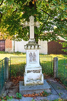
- Stone cross, consecrated in 1831 by Bishop Karl Borromäus Hanl von Kirchtreu and the lordly director Kozlík
- Střítežská rokle natural monument
literature
- Historický lexikon obcí České republiky 1869–2005 , part 1, p. 508
Web links
Individual evidence
- ↑ http://www.uir.cz/katastralni-uzemi/639575/Stritez-u-Skutce
- ^ Johann Gottfried Sommer : The Kingdom of Bohemia; Represented statistically and topographically. Volume 5: Chrudimer Kreis. Prague 1837, p. 244


