Stolany
| Stolany | ||||
|---|---|---|---|---|
|
||||
| Basic data | ||||
| State : |
|
|||
| Region : | Pardubický kraj | |||
| District : | Chrudim | |||
| Area : | 547 ha | |||
| Geographic location : | 49 ° 56 ' N , 15 ° 45' E | |||
| Height: | 288 m nm | |||
| Residents : | 391 (Jan. 1, 2019) | |||
| Postal code : | 538 03 | |||
| License plate : | E. | |||
| traffic | ||||
| Street: | Chrudim - Morašice | |||
| structure | ||||
| Status: | local community | |||
| Districts: | 1 | |||
| administration | ||||
| Mayor : | Petra Stará (as of 2018) | |||
| Address: | Stolany 114 538 03 Heřmanův Městec |
|||
| Municipality number: | 547891 | |||
| Website : | www.stolany.cz | |||
Stolany (German Stollan ) is a municipality in the Czech Republic . It is located five kilometers southwest of Chrudim and belongs to the Okres Chrudim .
geography
Stolany is located by the Červený potok on the Heřmanoměstecká tabule ( Hermannstädtler Tafel ). In the village are the Panský rybník and Malý rybník ponds, north of the Červenecký rybník. To the southeast rises the Dubinec (315 m nm), in the south the Rabštejnek (401 m nm) with the castle ruins of the same name , southwest of the Smrt (461 m nm) and the Holičská jedlina (388 m nm).
Neighboring towns are Bylany , Červenec, Markovice and Kozojedy in the north, Vrcha , Zavadilka and Pouchobrady in the northeast, Sobětuchy in the east, Říště, Podhůra, Kometa and Rabštejnská Lhota in the south-east, Rabštejn, Čejkovedrovice, Mýtka, and in the south in the south-west, Skupice, Dubina and Morašice in the west and Mlýn Prachovna and Lány in the north-west.
history
The first written mention of Stolany was in 1229 in a certificate of ownership from King Ottokar I Přemysl for the Opatowitz monastery . After the monastery was plundered and burned down in 1421 by the Hussites under Diviš Bořek von Miletínek and Aleš von Riesenburg , Stolany received secular owners. King Sigismund signed Stolany over in 1436, together with large parts of the former monastery property, to Diviš Bořek, who then formed the Kunburg dominion connected to the Pardubice dominion . In 1437 Diviš 'son Soběslav Mrzák of Miletínek inherited the rule.
In 1464 Georg von Podiebrad acquired both parts of the Pardubitz rule. On April 5, 1465 he signed the rule over to his sons Viktorin , Heinrich d. Ä. and Hynek von Münsterberg . In 1472 the rule of Pardubitz fell to Heinrich d. Ä. from Munsterberg to; From 1490 onwards, he pledged his property to Wilhelm von Pernstein . Stolany belonged to the part that Wilhelm von Pernstein acquired in 1492. Vojtěch von Pernstein left the village of Stolany including a share of Čejkovice in 1523 to Burian Anděl von Ronovec. In the course of a school repayment to the Lords of Pernstein , Stolany came to Johann von Pernstein in 1530 . His three sons transferred the estate back to Burian Anděl von Ronovec in 1550. This was followed in the landtäfligen Good Stolany a Solid build a stately home. After Burian Anděl's death, his daughter Eliška Andělka von Ronovec inherited the estate. She and her husband Václav Ples Heřmanský von Sloupno expanded the estate through acquisitions in the 1570s to include numerous villages from. a. in the iron mountains . In 1577 the Stolany estate was inherited in the land table to Václav Ples. After the death of Václav Ples in 1603, his son Zigmund Jan inherited the heavily indebted Stolany estate. He divided it and in the same year sold a share to Emperor Rudolf II. A little later he sold the other part to Stephan Georg von Sternberg auf Postelberg , who sold it on to Rudolf II. The Stolany manor was then connected to the Pardubice Chamberlain for a few years until Rudolf II sold it to Ladislaus Berka von Dubá in 1608 , who combined it with the Heřmanův Městec manor.
After the death of the childless Johann Dietrich Berka von Dubá, the rule of Heřmanův Městec with the Stolany estate fell to his sister Anna Maria Josephine von Khysl in 1636 . In 1661 she sold the rule to Johann von Sporck . In 1711, the later Chrudimer district chief Johann Joseph von Sporck inherited the rule. After the death of Johann Wenzel von Sporck , the rule was sold to Philipp Anton von Greiffenclau in 1798 . In 1828 the Greiffenclauschen heirs sold the rule to Rudolf Joseph Prince Kinsky .
In 1835 the village of Stollan or Stolany , located in the Chrudim district , consisted of 39 houses in which 297 people lived. In the village there was the branch church St. Nikolaus, a stately meierhof with an official residence, a sheep farm and a mill. The parish was Heřmanmiestetz . In 1846 a primary school was opened. Until the middle of the 19th century, Stollan remained subject to the allodial rule of Heřmanmiestetz.
After the abolition of patrimonial formed Stolany / Stollan 1849 with the districts Pouchobrady and Sobětuchy a municipality in the judicial district Chrudim . From 1868 the municipality belonged to the political district of Chrudim . In 1899 the old school was demolished and a new school building was built in its place. In 1900 there were 445 people in Stolany, in 1910 there were 409. Pouchobrady and Sobětuchy broke up in 1914.
From 1961 Stolany was part of the municipality Sobětuchy-Stolany, from 1966 the municipality Sobětuchy. In 1977 the school closed. The municipality of Stolany has existed again since August 31, 1990. In 1995 the school house was renovated and a kindergarten and elementary school were opened in it.
Community structure
No districts are shown for the municipality of Stolany. The Červenec residential area belongs to Stolany.
Attractions
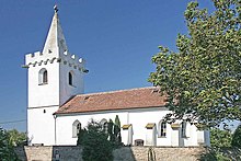
- Gothic church of St. Nicholas, it was built in the 14th century instead of a Romanesque predecessor. The late Gothic tower is striking, the top of which is formed by a crenellated wreath with stone gargoyles in the form of monsters and a brick spire . The unusual design of the tower indicates that it was built in the near future with the churches of St. Wenceslas in Staré Ždánice and St. Laurentius in Opatovice nad Labem , which have similar spiers. Artifacts of the Romanesque arched cornice are walled into the tower. The oldest part of the church is the main nave. Around the church there is a cemetery with a stone wall and an oval floor plan.
- Rectory built in the 14th century
- Remains of the former fortress
literature
- Historický lexikon obcí České republiky 1869–2005 , part 1, p. 516
Web links
Individual evidence
- ↑ http://www.uir.cz/obec/547891/Stolany
- ↑ Český statistický úřad - The population of the Czech municipalities as of January 1, 2019 (PDF; 7.4 MiB)
- ^ Johann Gottfried Sommer : The Kingdom of Bohemia; Represented statistically and topographically. Volume 5: Chrudimer Kreis. Prague 1837, p. 23


