Zámrsk
| Zámrsk | ||||
|---|---|---|---|---|
|
||||
| Basic data | ||||
| State : |
|
|||
| Region : | Pardubický kraj | |||
| District : | Ústí nad Orlicí | |||
| Area : | 747 ha | |||
| Geographic location : | 49 ° 59 ' N , 16 ° 8' E | |||
| Height: | 260 m nm | |||
| Residents : | 730 (Jan. 1, 2019) | |||
| Postal code : | 565 43 | |||
| License plate : | E. | |||
| traffic | ||||
| Street: | Stradouň - Dobříkov | |||
| Railway connection: | Česká Třebová – Praha | |||
| structure | ||||
| Status: | local community | |||
| Districts: | 3 | |||
| administration | ||||
| Mayor : | Zuzana Tvrzníková (as of 2018) | |||
| Address: | Zámrsk 95 565 43 Zámrsk |
|||
| Municipality number: | 581224 | |||
| Website : | www.zamrsk.cz | |||
Zámrsk (German Zamrsk , also Samrsk ) is a municipality in the Czech Republic. It is located five kilometers northwest of Vysoké Mýto and belongs to the Okres Ústí nad Orlicí .
geography
Zámrsk lies on both sides of the Loučná on the Choceňská tabule ( Chotzener Tafel ). The railway line Česká Třebová – Praha runs north of the village ; Zámrsk train station is one and a half kilometers northwest of the Nádraží Zámrsk settlement of the same name .
Neighboring towns are Rzy , Dobříkov and Hluboká in the north, Sruby and Slatina in the east, Šnakov and Vysoké Mýto in the south, Svatý Mikuláš and Vraclav in the south-west, Nová Ves , Malejov, Radhošť and Janovičky in the west and Nádraží Zámesten .sk and Týniší Zámrsko in the north.
history
Zámrsk was first documented on December 3, 1349 as the parish of the Litomysl bishopric when the Prague Archbishop Ernst von Pardubitz wrote to Pope Clement VI. mentioned the existence of a parish church in Zámrsk. There is evidence of a castle for 1469, which was owned by Vaňek von Zámrsk and which was destroyed by an army of Matthias Corvinus . The Lukavský von Lukawitz family built a castle in the Renaissance style in their place in the 16th century .
In 1613 the castle and the manor were owned by Karl Kapoun von Svojkow ( Karel Kapoun ze Svojkova ). Because of his participation in the Bohemian class uprising , his property was confiscated by the emperor after the battle of the White Mountain and sold in 1623 for 28,000 guilders to Albrecht von Waldstein , who combined the Zámrsk and Dobříkov estates and sold them to Vinzenz Muschinger von Gumpendorf in the same year . After his death Dobříkov was separated from Zámrsk in 1628 and sold to Theresia Margarethe von Schönkirchen. After several changes of ownership, the Counts Kolowrat-Liebsteinsky acquired the rule of Zámrsk in 1648. At the end of the 17th century, Leopold Ulrich Kolowrat-Liebsteinsky owned the estate on Adersbach . At the end of 1704, the Counts of Kolowrat-Liebsteinsky also acquired the Dobříkov estate and combined both goods into one allodial estate Dobřikau. The new Zámrsk Castle became the seat of power . In the 1740s, Johann Norbert Kolowrat-Liebsteinsky, whose son Hieronymus was born here, owned Zámrsk. Around 1750 the estate came to the Counts of Bubna and Lititz . Josepha von Bubna and Lititz sold the estate in 1780 to Georg Jenik Zásadský, knight of Gamsendorf , who founded the village of Nová Ves. The following owners were Georg's nephew Dionys Zásadský von Gamsendorf and then his son Friedrich.
In 1835, the in included Chrudim District allodial located Zamrsk, which was continued as allodial Dobřikau in the country table, an area of 3215 square fathoms yoke 735. The lordship operated two farms in Zamrsk and Dobřikau as well as two rich stone quarries, the material of which was used to build the Königgrätzer Chaussee. The extensive manorial forests stretched along the border with the Königgrätzer Kreis ; They were divided into the Dobřikau Revier (555 yoke) and Zamrsker Revier (262 yoke). The felled wood could be rafted into the Elbe on the Stillen Adler . The Zamrsk estate included the villages of Zamrsk, Neudorf , Dobřikau , Jaroslau and Wysoka with a total of 1765 inhabitants, including five Swiss and one Jewish family. The main source of income was agriculture, flax was spun in winter. The village of Zamrsk consisted of 69 houses in which 417 people, including a Helvetic and a Jewish family, lived. On the hill opposite the village on the left bank of the Laučna was the castle with a kitchen, orchard and ornamental garden, the brewery, the Meierhof and the parish church of St. Martin, parish and school. There was also a sheep farm, a brandy distillery, a retreat, a beer tavern, a paper mill and a grain mill with a board saw. Zamrsk was the parish for Neudorf, Dobřikau, Rzy and Slatina . In 1845, traffic on the Česká Třebová – Praha line began, and the Zamrsk train station was built in the open field near Janovičky. Until the middle of the 19th century, Zamrsk was the official village of the Zamrsk allodial estate.
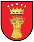
After the abolition of patrimonial Zámrsk formed from 1849 with the district Nová Ves a municipality in the judicial district Hohenmauth . From 1868 the community belonged to the political district Hohenmauth . In 1869 Zámrsk had 650 inhabitants and consisted of 80 houses. In 1900 517 people lived in the village, in 1910 there were 602. In 1930 Zámrsk had 539 inhabitants. Between the 1950s and 1970s, a new housing estate was laid out west of the palace gardens, and the train station estate was also built at the train station. Since 1960 the community has belonged to the Okres Ústí nad Orlicí . On January 1, 1962 Janovičky was incorporated. The Na Skalce settlement was established in the 1990s. In the 2001 census, 371 people lived in the 127 houses in Zámrsk. Since 2002 the community has had a coat of arms and a banner.
Community structure
The municipality of Zámrsk consists of the districts Janovičky ( Janowitz ), Nová Ves ( Neudorf ) and Zámrsk ( Zamrsk ). Basic settlement units are Janovičky, Nádraží Zámrsk, Nádraží Zámrsk-západ, Nová Ves and Zámrsk. Zámrsk also includes the malejov single shift.
The core town of Zámrsk is traditionally divided into five locations: Ves - the row of houses below the castle in the Loučná valley, Stará Ves - the old village on the other side of the river, Úvoz, Závodní strana and Sídliště - the settlement on the left side of the road to Choceň.
The municipality is divided into the cadastral districts Janovičky u Zámrsku and Zámrsk.
Attractions
- Zámrsk Castle , after nationalization it served as an educational institution for juvenile offenders from 1947, in which from 1948 convicts were mainly housed for violations of the communist regime. Since 1959, the State Archive of the Regions Pardubice and Hradec Kralove housed in the castle Zámrsk.
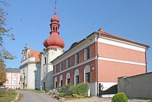
- The rococo church of St. Martin with a free-standing late baroque bell tower was built in 1781/82 on the site of a Gothic church. In the church are the tombstones of Wenzel Lukawsky von Lukawitz and Johann Lukawsky von Lukawitz († 1541). The organ was built in 1910. The bell, cast in 1596 by the Prague bell foundry workshop Brick von Cimperk, comes from the Church of Our Lady in the Cradle, which was demolished in 1792, or at the puddle ( kostel Panny Marie Na louži ) in Prague's old town .
- Statue of St. John of Nepomuk, in front of the church, created 1727
- Zámrsk cemetery, north of the chateau on the road to Dobříkov. The classicist crypt of the Jenik Zásadský von Gamsendorf family from 1847 and the neo-Renaissance style loggia tomb of the Gottlov family with the chapel dedicated to St. Cross.
- Distillery and starch factory on the Loučná, formerly a mill
- Zámrsk railway station, technical monument
Sons and daughters of the church
- Ferdinand Graf von Bubna and Littitz (1768–1825), Austrian Lieutenant Field Marshal
literature
- Historický lexikon obcí České republiky 1869–2005 , part 1, p. 548
Web links
Individual evidence
- ↑ http://www.uir.cz/obec/581224/Zamrsk
- ↑ Český statistický úřad - The population of the Czech municipalities as of January 1, 2019 (PDF; 7.4 MiB)
- ^ History (Czech), accessed December 4, 2018
- ^ Johann Gottfried Sommer : The Kingdom of Bohemia; Represented statistically and topographically. Volume 5: Chrudimer Kreis. Prague 1837, pp. 128-131
- ↑ https://www.zamrsk.cz/znak-a-prapor
- ↑ http://www.uir.cz/casti-obce-obec/581224/Obec-Zamrsk
- ↑ http://www.uir.cz/zsj-obec/581224/Obec-Zamrsk
- ↑ http://www.uir.cz/katastralni-uzemi-obec/581224/Obec-Zamrsk


