
Horní Heřmanice v Čechách
| Horní Heřmanice | |||||
|---|---|---|---|---|---|
|
|||||
| Basic data | |||||
| State : |
|
||||
| Region : | Pardubický kraj | ||||
| District : | Ústí nad Orlicí | ||||
| Area : | 1573 ha | ||||
| Geographic location : | 49 ° 58 ' N , 16 ° 43' E | ||||
| Height: | 578 m nm | ||||
| Residents : | 461 (Jan. 1, 2019) | ||||
| Postal code : | 561 33 | ||||
| License plate : | E. | ||||
| structure | |||||
| Status: | local community | ||||
| Districts: | 3 | ||||
| administration | |||||
| Mayor : | Tomáš Beran (as of 2020) | ||||
| Address: | Horní Heřmanice 91 561 33 Horní Heřmanice v Čechách |
||||
| Municipality number: | 580295 | ||||
| Website : | www.hornihermanice.cz | ||||


Horní Heřmanice (German Oberhermanitz , also for short Hermanitz , Herbordsdorf and 1304 Hermansdorf ) is a municipality in the district of Ústí nad Orlicí in the east Bohemian region of Pardubický kraj in the Czech Republic .
location
The mountain village is located directly on the former Bohemian-Moravian border, about 25 kilometers south of the Czech-Polish border below the easternmost tip of the Eagle Mountains at an altitude of about 600 meters above sea level. Neighboring communities are Cotkytle ( Zottkittl ), Výprachtice ( Weipersdorf ) and Štíty ( Schildberg ).
history
The village was probably founded by a locator named Herman . In 1304 Horní Heřmanice was first mentioned as Hermansdorf . At that time, a donation from several places in 1292 from King Wenceslaus II to the Königssaal monastery that he had founded was confirmed again. The monastery ceded to Heřmanice in 1358, as it was far away, as property to Johannes von Neumarkt , the Bishop of Naumburg , Leitomischl , Olomouc and Elekt von Breslau in exchange for other possessions and money.
At the beginning of the 15th century the place belonged to the rule of the diocese Leitomischl . In 1409 the place was separated from the spiritual rule by Johann von Bucca and mortgaged to Jan Smiřický ze Smiřic (German Johann von Schmiritz , Johann Smiřický von Smiřice ). According to Schwarz, the Hussite period (1419–1434) seems to have weakened Germanism in Hermansdorf , among other places , "be it that it has become a minority, be it that German places deserted and rose again as Czech (Czech) ones." 1453 the lien belonged to Markéta ze Zásady, the wife of Václav Preger, captain of Lanšperk Castle ; In the same year Heřmanice was transferred to Zdeněk Kostka von Postupitz , among other places , who brought Dolni and Horní Heřmanice into the Lanšperk domain.
At the beginning of the 40s of the 16th century the place was owned by Johann von Pernstein . In 1544 he was forced to sell Lanšperka Castle, three small towns and a number of surrounding villages, including Dolní and Horní Heřmanice, to Peter Bohdanecký von Hodkov due to high debts. Twenty years later, in 1564, the son of Johann von Pernstein, Vratislav von Pernstein , bought this part of Peter's heirs and connected it with the recently acquired Lanškroun. Since then, both parts (Lanškroun and Lanšperk) have been listed separately, but always as part of an administrative unit - the Lanškroun domain .

Both Dolní and Horní Heřmanice belonged to the district until the patrimonial administration was abolished. After 1850 they became independent and self-governing communities. In the 1921 census, there were 859 people in the 168 houses of Horní Heřmanice, including 844 Czechs and 14 Germans. In 1930 Oberhermanitz had 742 inhabitants; In 1939 there were 739. During the Second World War , Horní Heřmanice was incorporated into the Landskron district in the Reichsgau Sudetenland , where it formed a Czech language island. In the post-war history of the village, an agricultural cooperative was founded in 1953, which soon disintegrated and was renewed a few years later in 1959. In 1971 Horní Heřmanice, Dolní Heřmanice and Rýdrovice were combined into one municipality, which consists of three separate cadastral areas (districts).
Community structure
The community consists of the districts:
- Horní Heřmanice ( Ober-Hermanitz , also Oberhermanitz )
- Dolní Heřmanice ( Nieder-Hermanitz , also Niederhermanitz , Unter Hermanitz )
- Rýdrovice ( Riedersdorf )
Basic settlement units are Chudoba, Dolní Heřmanice, Horní Heřmanice, Rýdrovice and Záhora.
The municipality is divided into the cadastral districts of Dolní Heřmanice v Čechách, Horní Heřmanice v Čechách and Rýdrovice.
Attractions

- Baroque church of St. George with an older square tower in the west facade, a hall on the south side and a three-sided presbytery with sacristy on the north side. The church was built by the Italian architect Antonio Sala . The foundation stone was laid in 1702 (according to others in 1706), the inauguration took place in 1712, as the inscription on the portal translation confirms. The interior is uniform, high baroque. The baptistery with the carving of the baptism of Christ in Jordan dates from 1749. On the main altar there is a replica of the pilgrimage painting by Chrudimský Salvátor . Other altars are dedicated to the Holy Family and St. Nepomuck. The pulpit and the view of the organ are also baroque in design. The entire church area, including the cemetery gate and the chapel, is a cultural monument. The rectory dates from 1749.
- A baroque morgue with a round floor plan northeast of the church
- There is a statue of St. John of Nepomuk from 1760 on the parsonage, and a cross from 1788 in front of the church
- Watermill from 1748 (house number 103)
- Old, wooden country houses as evidence of folk architecture (house number 85 and others)
- Old homestead with barn (house number 42)

Statue of St. John of Nepomuk

Wooden country house - house number 85
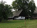
Homestead with barn - number 42

Watermill - house number 103


literature
- Josef Cibulka, Jan Sokol: Soupis památek historických a uměleckých v okresu Lanškrounském. (= Soupis památek historických a uměleckých v království Českém. Part 47). Prague, 1935, DNB 57903240X pp. 99-111. (Czech)
Web links
Individual evidence
- ↑ uir.cz
- ↑ Český statistický úřad - The population of the Czech municipalities as of January 1, 2019 (PDF; 7.4 MiB)
- ↑ Gustav Korkisch: history of Schönhengstgaues. Part 1. (= publications of the Collegium Carolinum. Volume 20). Verlag Robert Lerche, Munich 1966, pp. 32–33.
- ↑ Ernst Schwarz: Volkstumsgeschichte der Sudetenländer. Part II: Moravia-Silesia. (= Handbook of the Sudeten German Cultural History. Volume 4). Oldenbourg, Munich, 1987, p. 276.
- ↑ a b Jan F. Křivohlávek: History: Stručná history Dolních a Hornich Heřmanic . www.hornihermanice.cz , accessed: August 16, 2019. (Czech)
- ↑ Petra Bartáčková: postavení měst a městeček na Panství Lanškroun a Lansperk ve světle privilegií udělených Pernštejny v letech 1506-1588. In: Východočeské listy historické. 21-22, 2003-2004, pp. 291-318. (Czech)
- ↑ Chytilův místopis ČSR, 2nd updated edition, 1929, p. 353 Hertník - Heřmánkovice-Olivětín
- ^ Michael Rademacher: German administrative history from the unification of the empire in 1871 to the reunification in 1990. Landskron district. (Online material for the dissertation, Osnabrück 2006).
- ↑ uir.cz
- ↑ uir.cz
- ↑ uir.cz