
Dolní Morava
| Dolní Morava | |||||
|---|---|---|---|---|---|
|
|||||
| Basic data | |||||
| State : |
|
||||
| Region : | Pardubický kraj | ||||
| District : | Ústí nad Orlicí | ||||
| Area : | 3661 ha | ||||
| Geographic location : | 50 ° 7 ' N , 16 ° 48' E | ||||
| Height: | 615 m nm | ||||
| Residents : | 390 (Jan. 1, 2019) | ||||
| Postal code : | 561 69 | ||||
| License plate : | E. | ||||
| structure | |||||
| Status: | local community | ||||
| Districts: | 3 | ||||
| administration | |||||
| Mayor : | Richard Novák (as of 2017) | ||||
| Address: | Dolní Morava 35 561 69 Dolní Morava |
||||
| Municipality number: | 580163 | ||||
| Website : | www.obecdolnimorava.cz | ||||


Dolní Morava (German Niedermohrau ) is a municipality with 286 inhabitants (January 1, 2004) in the Czech Republic . It is 615 m above sea level. M., 7 km northeast of Králíky , in the border area between Bohemia and Moravia and belongs to the Okres Ústí nad Orlicí .
The popular winter sports resort at the southwestern foot of the Glatzer Schneegebirge was first mentioned in a document in 1577. Part of it is located in the Kralický Sněžník nature reserve. The elongated village lies in the valley of the March , which rises in the cadastral area of Velká Morava.
Districts
The municipality Dolni Morava includes the villages Horní Morava ( Obermohrau ) and Velká Morava ( Großmohrau ).
geology
North-east of Groß-Mohrau there is a deposit of light-colored marble , which was quarried in a quarry and was used in many ways under the name Schneeberg marble (Czech: Sněžníkovský mramor ).
Attractions
- Church of St. Alois, 1725
- Stezka v oblacích , "Path in the Clouds", lookout point in the Kłodzko Snow Mountains
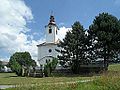
Aloisius Church


chapel

Stezka v oblacích


See also
- Nowa Morawa ( Neumohrau )
- Stara Morawa ( Altmohrau )