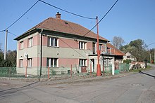
Rzy (Dobříkov)
| Rzy | ||||
|---|---|---|---|---|
|
||||
| Basic data | ||||
| State : |
|
|||
| Region : | Pardubický kraj | |||
| District : | Ústí nad Orlicí | |||
| Municipality : | Dobříkov | |||
| Area : | 301 hectares | |||
| Geographic location : | 50 ° 0 ′ N , 16 ° 7 ′ E | |||
| Height: | 253 m nm | |||
| Residents : | 66 (2011) | |||
| Postal code : | 565 43 | |||
| License plate : | E. | |||
| traffic | ||||
| Street: | Týnišťko - Choceň | |||
| Railway connection: | Česká Třebová – Praha | |||
Rzy (German Ry , 1940-1945: Ries ) is a district of the municipality Dobříkov in the Czech Republic . It is located seven kilometers north of Vysoké Mýto and belongs to the Okres Ústí nad Orlicí .
geography
Rzy is on the right side of Loučná on Choceňská tabule ( Chotzener Tafel ). State road II / 315 between Týnišťko and Choceň runs through the village ; The railway line Česká Třebová – Praha runs south of the village . The Rzovák pond is located in the Loučná floodplains between Rzy and the railway line. An extensive forest area extends to the north. In the northwest rises the Na Divišce (304 m nm), northeast the Kopanina (325 m nm),
Neighboring towns are Dolní Jelení and Rousínov in the north, Prochody, Újezd u Chocně , Chloumek and Darebnice in the Northeast, Dobříkov the east, Slatina in the southeast, Zámrsk and Nová Ves in the south, Janovičky , Nádraží Zámrsk and Týnišťko in the southwest, Bory and Francesco Lina in the West as well as Jaroslav , Ostřetín and Horní Jelení in the northwest.
history
The village was first mentioned in writing in 1546.
In 1835 the village of Rzy, located in the Chrudim district , consisted of 19 houses in which 103 people lived. There was a keeper's house in the village. The parish was in Zamrsk . Until the mid-19th century, the village of the royal remained dowry town H Hohenmauth servants.
After the abolition of patrimonial Rzy formed from 1849 a district of the municipality Dobříkov in the judicial district Hohenmauth . From 1868 the village belonged to the political district Hohenmauth . In 1869 Rzy had 96 inhabitants and consisted of 20 houses.
In 1900 93 people lived in Rzy, in 1910 there were 105. Rzy broke away from Dobříkov in 1906 and formed its own community. In 1930 the community had 115 inhabitants. 1960 Rzy was assigned to the Okres Ústí nad Orlicí . On June 14, 1964, the new incorporation took place after Dobříkov. In the 2001 census, 72 people lived in Rzy's 30 houses.
Local division
The district of Rzy forms a cadastral district.
literature
- Historický lexikon obcí České republiky 1869–2005 , part 1, p. 540
Web links
Individual evidence
- ↑ http://www.uir.cz/katastralni-uzemi/627879/Rzy
- ^ Johann Gottfried Sommer : The Kingdom of Bohemia; Represented statistically and topographically. Volume 5: Chrudimer Kreis. Prague 1837, p. 127
- ↑ http://www.uir.cz/casti-obce/027871/Rzy


