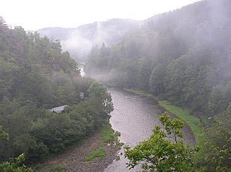
Sázava (Moldova)
| Sázava | ||
|
course |
||
| Data | ||
| Water code | CZ : 1-09-01-001 | |
| location | Czech Republic | |
| River system | Elbe | |
| Drain over | Vltava → Elbe → North Sea | |
| source | East of Nová Huť in the Žďárské vrchy 49 ° 40 ′ 19 ″ N , 15 ° 56 ′ 8 ″ E |
|
| muzzle | At Davle , OT Sázava, in the Moldau Coordinates: 49 ° 53 '11 " N , 14 ° 23' 38" E 49 ° 53 '11 " N , 14 ° 23' 38" E
|
|
| length | 218.2 km | |
| Drain |
MQ |
25 m³ / s |
| Left tributaries | Poděšínský potok, Olešnický potok , Šlapanka, Želivka , Blanice , Konopišťský potok, Janovický potok | |
| Right tributaries | Sázavka, Jevanský potok, Mnichovka | |
| Reservoirs flowed through | Vranská dam | |
| Medium-sized cities | Žďár nad Sázavou , Havlíčkův Brod | |
| Small towns | Přibyslav , Světlá nad Sázavou , Týnec nad Sázavou , Davle | |
| Communities | Krhanice , Pikovice | |
| Navigable | 208.3 km with pleasure boats | |
|
Sázava |
||
The Sázava (/ saːzava /, German Sasau or Sazawa ) is an orographically right tributary of the Vltava . It drains part of the Bohemian-Moravian Highlands and the northern region of the Středočeská pahorkatina . The catchment area is 4,350 square kilometers, the length of the river 218.2 kilometers; of which 208.3 kilometers can be traveled by pleasure craft.
course
The Sázava rises in the Žďárské vrchy ( Saar Mountains ) on the historical border between Bohemia and Moravia . Its source is located between the Kamenný vrch ( stone mountain , 803 m nm) and the Šindelný vrch (806 m nm), on the south-western side of which the Svratka river begins. The source of the Stržský potok east of Cikháj (Lage) and the pond Velké Dářko are often incorrectly mentioned as the source of the Sázava.
On its upper reaches it initially flows in a westerly direction on Moravian territory through the forests of the Saar mountains. At Nová Huť the Sázava reaches the Bohemian region. There it changes its course to the south and flows through the Velké Dářko pond. Below Polnička , you run past the Žďár monastery and through Moravia again. In Žďár nad Sázavou the river turns again to the west; between Hamry nad Sázavou and Sázava it crosses the old Bohemian-Moravian border.
The middle and lower reaches of the Sázava then lead in a north-westerly direction through Bohemia. At the ruins of the Ostrov monastery near Davle , south of Prague , the Sázava flows into the Vltava.
The Sázava is a popular river with water sports enthusiasts, even if the water level is quite low in summer. Between Žďár nad Sázavou and Přibyslav it flows in a steep slope with rapids through a deep valley. Behind Přibyslav the valley opens and the river flows in a meandering river bed towards Havlíčkův Brod . This landscape is offered to water sports enthusiasts as far as Světlá nad Sázavou . Here the valley narrows and offers a varied ride with many rapids. The whitewater section called Stvořidla is a nature reserve; it is one of the most popular destinations for water sports enthusiasts in the Czech Republic, but only accessible for rafts and closed boats (kayaks) and when the water level is high enough. After a few kilometers, there is a transition to a medium flow velocity with several weirs and a moderate flow velocity (ZW). This section is used by many canoes in the summer season because on the one hand it has a good infrastructure (tent sites, pubs, rental points) and on the other hand it is easy to access with the local train.
From Týnec nad Sázavou and Krhanice the Sázava flows again through a deep valley with steep slopes in which rapids form again due to a stony river bed. It continues to flow through leisure areas for nature lovers. After Pikovice the river calms down again and flows into the reservoir of the Vrané hydroelectric power station .
Larger tributaries
- Šlapanka , from the left, km 164.4
- Sázavka, from the right, km 144.8
- Želivka , from the left, km 98.9
- Blanice (Vlašimská), from the left, km 78.6
- Jevanský potok, from the right, km 48.7
- Mnichovka, from the right, km 37.6
- Konopišťský potok, from the left, km 31.3
- Janovický potok, from the left, km 19.2
Web links
Individual evidence
- ↑ Turistika.cz: "Pramen řeky Sázavy"
- ↑ Vodácká navigace a kilometráž. Retrieved November 8, 2018 .


