Drygalskiberge
| Drygalskiberge | ||
|---|---|---|
|
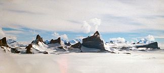
The main massif of the Drygalskiberge seen from the northeast |
||
| Highest peak | Matterhorn ( 2931 m ) | |
| location | Queen Maud Land , East Antarctica | |
| part of | Orvinfjella | |
|
|
||
| Coordinates | 71 ° 45 ′ S , 8 ° 15 ′ E | |
| surface | 500 km² | |
The Drygalskiberge ( Norwegian Drygalskifjella ) in Neuschwabenland are about 500 km², partly ice-free mountains, which are named after Erich von Drygalski , the leader of the first official German Antarctic expedition .
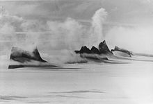
The mountains were discovered by the German Antarctic Expedition in 1938/39 under the direction of Alfred Ritscher and documented with the help of aerial photographs . During the Norwegian Antarctic Expedition 1956–1960, the mountains were photographed again because the German aerial photos were lost in World War II . The first geological research took place as part of the 4th Soviet Antarctic Expedition 1958-1960. Systematic geological mapping and exploration was continued by the GeoMaud expedition in 1995–1996 .
geography
The mountain range consists of two geomorphologically different areas. The northern part forms a wavy, glaciated promontory that rises gently from 1200 to 1500 m. Several scattered groups of nunataks protrude only a few meters from the ice. The southern part consists of a high mountain massif , some of which protrudes more than 1000 m from the ice, which roughly has the outline of the number 1 and bears the name Fenriskjeften (pine of the Fenriswolf ). The highest peaks are the Matterhorn ( Norwegian Ulvetanna , 2931 m), the Kintanna (2724 m) and the Holtanna (2650 m). The mountains are bounded to the west and east by wide glaciers ; the Vinjebreen in the west separates the Drygalskiberge from the Filchnerberge , in the east the Sigynbreen forms the border to the Holtedahlfjella . Both glaciers join north of the mountain range and flow out onto the Lazarev Ice Shelf .
geology
The northern part of the mountain range consists of highly metamorphic , multiply folded gneiss and marbles , the parent rocks of which have a Mesoproterozoic age. Most recently, the rocks were deformed about 540 mya ago during the collision between West and East Gondwana and the earth's crust was greatly thickened. The deeper part of the crust partially melted, forming huge alkali granite plutons that solidified 500 million years ago and are now exposed in the southern part of the mountain range.
literature
- Norsk Polarinstitutt (Ed.): Blad K5 Filchnerfjella Nord . Oslo 1966 (topographic map 1: 250,000).
- Hans-Jürgen Paech (Ed.): International GeoMaud Expedition of the BGR to Central Dronning Maud Land in 1995/96 . Volume I: Geological Results . Schweizerbart, Stuttgart 2004, ISBN 978-3-510-95923-5 , p. 499 .
- Norbert W. Roland: Pan-African granitoids in central Dronning Maud Land, East Antarctica: petrography, geochemistry, and plate tectonic setting . In: Royal Society of New Zealand Bulletin . tape 35 , 2002, pp. 85-91 .
Web links
- Australian Antarctic Data Center datasheet ; Retrieved February 25, 2010


