
Duxbury, Massachusetts
| Duxbury | |||
|---|---|---|---|
Location in Massachusetts
|
|||
| Basic data | |||
| Foundation : | 1637 | ||
| State : | United States | ||
| State : | Massachusetts | ||
| County : | Plymouth County | ||
| Coordinates : | 42 ° 3 ′ N , 70 ° 40 ′ W | ||
| Time zone : | Eastern ( UTC − 5 / −4 ) | ||
| Residents : | 15,059 (as of 2010) | ||
| Population density : | 244.9 inhabitants per km 2 | ||
| Area : | 97.4 km 2 (approx. 38 mi 2 ) of which 61.5 km 2 (approx. 24 mi 2 ) is land |
||
| Height : | 11 m | ||
| Postcodes : | 02331, 02332 | ||
| Area code : | +1 508/781 | ||
| FIPS : | 25-17895 | ||
| GNIS ID : | 0618338 | ||
| Website : | www.town.duxbury.ma.us | ||

Duxbury is a town ( Town ) in Plymouth County in the US state of Massachusetts with 15,059 inhabitants (2010).
geography
The city lies on the eastern coast of Duxbury Bay , which extends into Cape Cod Bay in the west . At a distance of 35 kilometers to the south is Wareham . Boston is 55 kilometers away in the northwest. The Massachusetts Route 3 runs through the middle of Duxbury.
history

The area was already inhabited around 12,000 years ago by the Wampanoagindians , who lived there by hunting and fishing. They called the place Mattakessett meaning: "place of many fish". The first European settlers, the Pilgrim Fathers , settled in 1620. The city was officially founded as the Town of Duxham in 1637. The name was chosen based on Duxbury Hall in England , the ancestral seat of the Standish settler family.
In the 17th and 18th centuries , the place initially developed into a quiet community that lived from agriculture and fishing. When the shipbuilding industry was added as a new branch of industry at the beginning of the 19th century , the population grew rapidly. By the end of the century, 180 ships had been completed in 20 different shipyards , which led to great prosperity in the city. Many splendid houses were built during this time. In honor of Captain Myles Standish, the Myles Standish Monument was built between 1872 and 1898 as a landmark for the city. When the demand for ships decreased, the place opened up new economic opportunities as a holiday resort and retirement home.
In recent times the place has become increasingly attractive in terms of tourism and has become active with offers in various water sports and fishing.
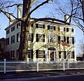
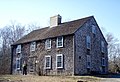
Some historically valuable buildings and places, most of them the homes of former ship captains , are on the list of entries in the National Register of Historic Places in Plymouth County, Massachusetts . These include: Old Shipbuilder's Historic District , King Caesar House , John and Priscilla Alden Family Sites , Captain Daniel Bradford House , Capt. Gamaliel Bradford House , Capt. Gershom Bradford House , First Parish Church , Pillsbury Summer House , Alexander Standish House , Tarkiln School , Wright Memorial Library and Myles Standish Burial Ground .
Old Shipbuilder's Historic District

King Caesar House

Capt. Gershom Bradford House
John and Priscilla Alden Family Sites

Tarkiln School

Wright Memorial Library


Demographic data
In 2010 a population of 15,059 people was determined, which corresponds to an increase of 5.69% compared to the year 2000.
sons and daughters of the town
- Patrick Leahy , ice hockey player
- Tim Leahy , ice hockey player
- Mark Murphy , ice hockey player
- George Partridge , politician
- Peleg Sprague , politician
- Charles Turner Jr. , politician
- Peleg Wadsworth , politician
Individual evidence
- ↑ US Postal Service - ZIP Codes
- ↑ naming
- ↑ History ( Memento of the original from October 26, 2016 in the Internet Archive ) Info: The archive link was inserted automatically and has not yet been checked. Please check the original and archive link according to the instructions and then remove this notice.
- ^ Population data
Web links
- myles-standish-monument - Myles Standish Monument
- duxburyhistory - The Duxbury Rural & Historical Society
- artcomplex - The Art Complex Museum
- alden.org - Alden House