
East Pilbara Terrane
The East Pilbara Terrane is the eastern part of the Pilbara Craton in northern Western Australia , which is more important in terms of area . This extremely old crustal section , which dates back to the Paleoarchean with its very well preserved supracrustal sequence, is of great importance for understanding the archaic crustal evolution of the earth.
etymology
There are two explanations for the origin of the word pilbara :
- bilybara from the language of the Banyjima and the Nyamal . This dialect word from the Aboriginal language means dry .
- pilbarra is an Aboriginal word for mullets ( Mugil cephalus ), which can still be found today in Pilbara Creek , a tributary of the Yule River . The Pilbara Goldfield , discovered in 1885, was named after the Pilbara Creek , which then carried its name to the entire region.
introduction
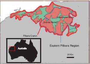
The East Pilbara Terrane, centered at 119 ° East and 21 ° South, also known as Eastern Pilbara Terrane or East Pilbara Granite Greenstone Terrane , is the only terran with a 3600 to 2500 million year old crust in its original state besides the Kaapvaal Craton . Together with the West Pilbara Terrane , it forms the Pilbara craton in the Pilbara region. Magnetic field and gravity measurements show an area of 250,000 square kilometers for the Kraton, of which only 60,000 square kilometers are open in the northern third. The rest is covered by discordant, neo-archaic to paleoproterozoic rocks that make up the Fortescue Basin , the Hamersley Basin and the Turee Creek Basin ( Fortescue Group , Hamersley Group and Turee Creek Group of the Mount Bruce Supergroup ). In the north and northeast, the East Pilbara Terrane borders on the Canning Basin , whose Paleozoic sediments ( Silurian to Devonian ) cover it discordantly. On the eastern edge, the terran is in contact with the Proterozoic Paterson Orogen .
Seismic profiles show that the crust thickness generally increases from 28 kilometers in the north to 32 kilometers in the south. However, the thickness of the sediment cover increases in a wedge shape from east to west.
The East Pilbara Terrane essentially consists of mafic and ultramafic metamorphic rocks of the greenstone association , intrusive granitic dome structures and volcanic sediments . The green stones, whose degree of metamorphism ranges from below the green slate to the amphibolite facies, are predominantly regarded as the remains of former volcanic belts, but their origin remains the subject of countless scientific disputes. Terranes such as Isua and Barberton with comparable lithologies were interpreted either as accretion belts along a subduction zone or as the product of vertical compensatory movements. The difference is fundamental because it determines when and how plate tectonics began on Earth.
Lithological structure
The East Pilbara Terrane can be lithologically (and also temporally) divided into two very different sections:
- Early crust formation between 3800 and 3530 million years BP
- Intrusive granite domes with greenstone belts in between in the period 3530 to 3230 million years BP (deposit of the Pilbara Supergroup )
Paleoarchaic crust
Remnants of the paleoarchaic crust of the East Pilbara Terrane can be found in various granite complexes. For example, 3580 million year old xenolites made of Gabbroic anorthosite are found in Shaw granite . The Warrawagine granite contains 3660 to 3580 million year old inclusions of biotite tonalites now present as gneiss . In addition, detritic zircons were 3800 to 3600 million years old BP. This suggests the presence and erosion of continental crust around 300 million years before the formation of today's oldest greenstones.
Granite domes and green stone belt

A predominant part of the lithologies in the East Pilbara Terrane are dominated by granite domes and the greenstone belts of the Pilbara Supergroup. The granite domes are typical TTG or TTG-like rocks in their composition - tonalites, trondhjemites and granodiorites . The following granite domes can be distinguished:
- Carlindi Granite Complex
- Corunna Downs Granite Complex
- Mount Edgar Granite Complex
- Muccan granite complex
- Shaw granite complex
- Warrawagine granite complex
- Yule granite complex
In the greenstone belts of the Pilbara Supergroup, strongly modified komatiitic basalts , tholeiitic basalts and volcanic sedimentary rocks are found. The chemism of these volcanic rocks ranges from ultramafic to mafic to acidic educts. As examples of ultramafic rocks, not only komatiites but also relatively rare dunites may be given. A distinction is made between the greenstone belts:
- Coongan greenstone belt
- Kelly greenstone belt
- Lalla Rookh greenstone belt
- Marble bar greenstone belt
- McPhee greenstone belt
- Mosquito Creek greenstone belt
- North Pole Greenstone Belt
- North Shaw Greenstone Belt
- Pilgangoora greenstone belt
- Pincunah greenstone belt
- Shay gap greenstone belt
- Soanesville greenstone belt
- Wodgina greenstone belt
The Pilbara Supergroup can be subdivided as follows (from hanging to lying ):
Fossil content
Fossils are relatively numerous in the Pilbara Supergroup and occur in various depositional environments. Stromatolites , microbial mats and microfossils appear in the sediments that separate the volcanogenic cycles . Hydrothermal habitats, such as those found near hot springs or black smoker tubes, were preferred here - examples of this can be found in the 3480 million year old BP Dresser Formation or in the 3240 million year old BP Kangaroo Caves. Formation . The microfossils of the Apex-Chert achieved fame as the oldest fossil find ever described by J. William Schopf . Their authenticity is still controversial (Brasier-Schopf debate).
The stromatolites of the Strelley Pool Formation (<3426 million years BP) are of shallow marine origin and represent a first-time carbonate shelf. Paleorchaic life may also be found in ribbon ores (BIF), as oxidizing bacteria or photosynthesizing microbiota are required to precipitate the divalent iron. The oldest BIF horizon of the Pilbara Supergroup can be found in the Coucal formation .
Lacustrine stromatolites are found in the neo-archaic Fortescue basin in carbonate layers in the Kylena Formation (around 2741 million years BP), in the Tumbiana Formation (2727 to 2715 million years BP) and in shallow water chert layers at the base of the Jeerinah Formation ( around 2690 million years BP). In the Hamersley Basin, the water depth was too great for stromatolites to thrive, with the exception of the Carawine Dolomite , a shallow-water dolomite rich in stromatolites. The Wooly Dolomite (around 2031 million years BP) of the Lower Wyloo Group and the Duck Creek Dolomite of the Upper Wyloo Group are also stromatolite leaders.
TTG rocks
TTG rocks are an amalgam of tonalites, trondhjemites and granodiorites, which emerged from the melting of the high-pressure mafic crust. Because of their low density and intrusive nature, these rocks are of crucial importance for the formation of archaic greenstone complexes. TTG rocks also appear in other archaic greenstone belts such as B. Isua and Barberton. How it came about is still controversial. Some authors link the development process to subduction processes , whereas others explain TTG melts through the impingement of mantle diapirs . The debate about the origin of TTG rocks takes a central position in determining the beginning of plate tectonics .
Deposits
The very diverse mineralizations in the East Pilbara Terrane are related to the magmatic intrusions caused by mantle diapirs. The following types of deposits can be found:
- Copper-zinc-lead-barite mineralization of the VHMS type
- Hydrothermal barite as quartz-barite veins and as chert-barite deposits that displace the initial sediment
- Polymetallic and base metal deposits in acidic porphyries
- Copper-molybdenum mineralization of the porphyry-copper type
- Mesothermal gold mineralization in granite domes encircling shear zones
Some of these paleoarchaic deposits are the world's oldest of their type:
- Barite in the 3480 million year old dresser formation
- VHMS in the 3,465 million year old Duffer Formation
- Polymetallic mineralization with Cu-Pb-Zn-Au-Ag in a 3450 million year old acidic porphyry stock
- Epigenetic gold veins dated 3,400 million years ago.
The most economically important deposits of the Pilbara Craton are located in the De Gray Superbasin. Iron ores from various levels in the Gorge Creek Basin (3,050 to 3,020 million years BP) have been mined for over 50 years. The Croydon Group contains approximately 2950 million year old VHMS and stratiform lead-zinc and copper mineralizations in several locations. Ultramafic to mafic layer intrusions (2950 to 2920 million years BP) are for their part rich in nickel- copper and vanadium - titanium - magnetite mineralizations. The last mineralization in the actual East Pilbara Terrane was related to the intrusion of the Split Rock Supersuite (2890 to 2830 million years BP). It led to an accumulation of tin and tantalum on the edge of the post-orogenic granite .
The Hamersley Basin is world famous for its iron deposits bound to the ribbon ores . In particular, the Marra Mamba Iron Formation (2630 to 2597 million years BP) and the Brockman Iron Formation (2481 to 2454 million years BP) are among the world's largest iron deposits with up to 60% Fe.
Dome and keel structuring
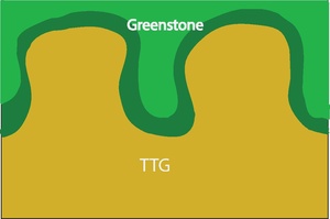
The dome-and-keel structure is characteristic of the East Pilbara Terrane. It is also found in a comparable way in the Barberton greenstone belt in South Africa . Their origin is explained by density inversion triggered, partly convective circulation . The pattern of light granite domes surrounded by dark greenstone belts can be seen very well on satellite images. The steep, narrow nature of the synclines trapped between the granite bulges ( anticlines ) is clearly visible on the profiles . The interior of the granite domes is usually only slightly deformed, but their edge area and the surrounding greenstone belt show a high degree of deformation. The degree of metamorphosis increases as the keel structures approach.
Partly convective circulation
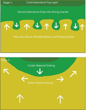
The geology and structure of the East Pilbara Terrane can be explained well with partial convective circulation. In order for the convection to start, there must be a density inversion. Due to an initial instability, cold, dense rock (green stones) then begins to sink into hotter, lighter material (granite). In return, the lighter material then rises in a compensatory movement like a dome or column. A characteristic anti-line syncline structure is created, with the green stones sunk into the syncline being exposed to the highest degree of deformation. The diagram opposite shows the development in two stages. In step 1, the heat supplied by the partially melted granite is shielded by the cooler greenstone ceiling, instability has started and the greenstone begins to sink. In level 2, the many sporadic, short-wave subsidence have combined to form a larger structure consisting of keel and dome. The end result is a structuring as it is now in the East Pilbara Terran and which is also known as vertical tectonics .
Geodynamic development
After the formation of the paleoarchaic microcontinent, greenstone sedimentation began with at least eight volcanic cycles around 3525 million years ago. The cause is assumed to be penetrating mantle diapirs , which began to melt at the border to the lower crust due to pressure relief. The cycles provided ultramafic-mafic-acidic magma sequences , their individual lifespan extended over about 10 to 15 million years. The 15,000 to 20,000 meter thick Pilbara Supergroup emerged from the magmas supplied, a supracrustal sequence of predominantly volcanic origin. The Pilbara supergroup can in three by unconformities separate groups are divided (by the hanging wall of the footwall ):
- Sulfur Springs Group - 3255 to 3230 million years BP
- Kelly Group - 3350 to 3315 million years old BP
- Warrawoona Group - 3525 to 3426 million years BP
The two discordances correspond to a hiatus of 75 and 60 million years. This very long-lasting suspension of volcanic activity was preceded in both cases by deformation and metamorphosis, accompanied by subaeric erosion and the sedimentation of clastic shallow water sediments. Examples of this are the Strelley Pool Formation , which is up to 1,000 meters thick, at the base of the Kelly Group and the Leilira Formation, which is up to 3,900 meters thick, at the base of the Sulfur Springs Group.
During the deposition of the Pilbara Supergroup, intrusive, partly sub-volcanic TTG magmatism occurred, which took place in four phases:
- Cleland Supersuite - 3270 to 3230 million years BP
- Emu Pool Supersuite - 3320 to 3290 million years BP
- Tambina Supersuite - 3460 to 3420 million years BP with deformation phase D 2
- Callina Supersuite - 3530 to 3460 million years BP with deformation phase D 1
As mentioned above, this magmatism is responsible for the dome-and-keel structure of the East Pilbara Terrane.
The geodynamic positioning of the Pilbara Supergroup is still controversial. Since mid-ocean ridges and island arches are apparently eliminated because of sediment thickness and chemistry, their formation as flood basalts on mighty oceanic plateaus such as the Kerguelen Plateau is currently advocated.
Further geodynamic development after the deposit of the Pilbara Supergroup
By around 3230 million years BP, a thick continental crust had established itself in the Pilbara craton. Between 3230 and 3160 million years BP, expansion tectonics began, rift basins formed and the craton was divided into several parts. The Kurrana Terrane split off on the southeast edge of the East Pilbara Terrane and the Karratha Terrane on the northwest edge . Together with the Regal Terrane (3160 to 3070 million years BP) and the Sholl Terrane (3130 to 3110 million years BP), which emerged a little later, the Kurrana Terrane forms the West Pilbara Terrane , which is due to the northwest-southeastern narrowing of the individual terrans around 3070 BP emerged millions of years ago. The narrowing continued, however, so that the West Pilbara Terrane (also around 3,070 million years BP) finally docked with the East Pilbara Terrane in the Prinsep Orogeny .
After orogeny, subsidence phenomena occurred in the docking zone ( Central Pilbara Tectonic Zone ) and the discordant De Gray Superbasin arose between 3050 and 2930 million years BP . In the De Gray Superbasin in the West Pilbara Terrane, three series of pools can be distinguished from one another by discordances:
- Gorge Creek Basin (3050 to 3020 million years BP)
- Whim Creek Basin (3010 to 2990 million years BP)
- Mallina Basin (2970 to 2940 million years BP)
The Mosquito Creek Basin was formed on the southeast edge of the East Pilbara Terrane between 2980 and 2930 million years BP . After the granitic Split Rock Supersuite penetrated the sediments of De Gray Superbasin between 2890 and 2830 million years BP, calm returned to East Pilbara Terane until around 2780 million years BP. From 2780 million years BP onwards the aforementioned deposits of the Fortescue Group (up to 2630 million years BP), the Hamersley Group (2630 to 2450 million years BP) and the Turee Creek Group (2420 to 2300 million years BP) followed. With the northward advancing fold belt of the Ophthalmian Orogeny around 2300 million years BP, the sedimentation in the Turee Creek Basin ends.
Orogeny was followed by a hiatus of 90 million years. The sediments of the Lower Wyloo Group then formed in the newly formed Ashburton Basin , which lay discordantly over the sediments of the Hamersley Basin. Sedimentation ended around 2030 million years BP after the Wooly Dolomite was deposited . After the dolerite intrusion (gang shares), Panhandle Orogeny occurred around 2000 million years ago . The final Upper Wyloo Group sedimented BP discordantly over the Lower Wyloo Group after a long gap between 1830 and 1790 million years. The orogen front of the Capricorn Orogeny , advancing towards 1786 million years BP, ended development in the Ashburton Basin and led to the continental collision between the Pilbara and Yilgarn craton .
Individual evidence
- ^ Laurie, Angelique: The formation of Earth's early Felsic continental crust by water-present eclogite melting . 2013, p. ii, 31 , doi : 10.1111 / ter.12015 .
- ^ Nicholas Arndt: Kaapvaal Craton, South Africa . In: Encyclopedia of Astrobiology . 2011, ISBN 978-3-642-11271-3 , pp. 885 , doi : 10.1007 / 978-3-642-11274-4_1894 .
- ^ NJ McNaughton: Are anorthositic rocks basement to the Pilbara Craton? In: Geological Society of Australia . 1988, p. 272-273 .
- ↑ A. Hickman, M. Van Kranendonk: Early Earth evolution: evidence from the 3.5-1.8 Ga geological history of the Pilbara region of Western Australia . In: Episodes . tape 35 , no. 1 , 2012, p. 283-297 .
- ^ A. Hickman, inter alia: Evolution of active plate margins: West Pilbara Superterrane, De Gray Superbasin, and the Fortescue and Hamersley Basins - a field guide . Geological Survey of Western Australia, 2010, p. 74 .
- ^ AH Hickman: Review of the Pilbara Craton and Fortescue Basin: crustal evolution providing environments for life . In: Island Arc . tape 21 , 2012, p. 1-31 .
- ^ AF Trendall, HG Blockley: Precambrian iron formations . In: PG Eriksson, among others The Precambrian Earth: Tempos and events in Precambrian time (Ed.): Developments in Precambrian Geology . tape 12 . Elsevier, 2004, p. 403-421 .
- ↑ GJH McCall ,: A critique of the analogy between Archaean and Phanerozoic tectonics based on regional mapping of the Mesozoic-Cenozoic plate convergent zone in the Makran, Iran . In: Precambrian Research . tape 127 , no. 1–3 , 2003, pp. 5-17 , doi : 10.1016 / S0301-9268 (03) 00178-5 .
- ^ Rapp, Robert: First Origins of Archean Continental Crust: Assessing Experimentally the Roles of Mafic Versus Ultramafic Sources . In: Journal of Conference Abstracts . tape 4 , no. 1 , 1999.
- ^ DL Huston et al: The timing of mineralization in the Archaean Pilbara Craton, Western Australia . In: Economic Geology . tape 97 , 2002, p. 691-693 .
- ^ JG Blockley: Iron ore . In: Geology and Mineral Resources of Western Australia . Memoir 3rd Geological Survey of Western Australia, 1990, pp. 679-692 .
- ↑ AH Hickman: Pilbara Supergroup of the East Pilbara Terrane, Pilbara Craton: updated lithostratigraphy and comments on the influence of vertical tectonics . Geological Survey of Western Australia. Annual Review, 2011.
- ↑ RH Smithis, including: Formation of Paleoarchean continental crust through infracrustal melting of enriched basalt . In: Earth and Planetary Science Letters . tape 281 , no. 3–4 , 2009, pp. 298-306 , doi : 10.1016 / j.epsl.2009.03.003 .