Erlengraben (Wiesbach)
| Alder Trench | ||
|
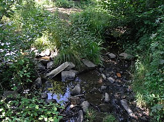
The Erlengraben, on the right, flows into the Wiesbach, on the left |
||
| Data | ||
| Water code | DE : 248483214 | |
| location |
Taunus
|
|
| River system | Rhine | |
| Drain over | Wiesbach → Usa → Wetter → Nidda → Main → Rhine → North Sea | |
| source | in the eastern Hintertaunus southwest of Wehrheim - Pfaffenwiesbach 50 ° 19 ′ 9 ″ N , 8 ° 35 ′ 3 ″ E |
|
| Source height | 329 m above sea level NHN | |
| muzzle | on the southern edge of Pfaffenwiesbach in the Wiesbach Coordinates: 50 ° 19 ′ 37 ″ N , 8 ° 36 ′ 22 ″ E 50 ° 19 ′ 37 ″ N , 8 ° 36 ′ 22 ″ E |
|
| Mouth height | 285 m above sea level NHN | |
| Height difference | 44 m | |
| Bottom slope | 24 ‰ | |
| length | 1.8 km | |
| Catchment area | approx. 2.9 km² | |
The Erlengraben is a creek about two kilometers long with two very different spring branches in a straightened and mostly fortified, alder-lined bed in the eastern Hintertaunus , which mainly flows through the forest or the edge of the forest and from the left in the Pfaffenwiesbach district of Wehrheim in the Hessian Hochtaunuskreis and southwest into the Wiesbach flows.
geography
course
The Erlengraben arises in the corridor lane between the larger forest areas around the Binzelberg in the northwest and the Süßberg ( 389 m above sea level ) in the southeast, less than 50 meters to the right of the district road K 728, which runs through this narrow forest from Wehrheim in the southeast to Pfaffenwiesbach in the northeast leads. It rises in a meadow at an altitude of about 329 m above sea level. NHN . From the source to the mouth it flows very steadily in a north-easterly to east-northeast direction, nowhere more than 250 meters to the right of the county road and almost parallel to it. The first about five hundred meters of it, consisting of only sparse bushes, it pulls through meadows and fields, after which it is reinforced on its right by a forest stream coming from the south on the waldeck of the Lochwiesen corridor , whose course of almost one kilometer here is almost double is as long as his.
The Erlengraben now runs about nine hundred meters on foot of the slope and the hall edge of the area planted with mixed forest Heßberges along the long north spur of Süßberg ( 389.3 m above sea level. NHN ) in the south. On this section, the Erlenbach, approaching through the corridor from the edge of the forest area to the left of the county road, runs towards him from the left and west . Immediately afterwards he passes the Aussiedlerhof Am Weisse Stein . It then detaches itself with its gallery from the forest that ends on the right and after another four hundred meters flows through its meadow basin, above which there are already settlement houses close to the village on the left slope, on the southern edge of Pfaffenwiesbach at an altitude of about 288 m above sea level. NHN from the left into the Wiesbach coming from behind the Heßberg from the south .
Catchment area
The Erlengraben drains about 2.9 km² of the eastern Hintertaunus from a sector southwest of its confluence with the Wiesbach. The watershed stretches from the mouth southwards over the ridge of the Heßberg to the summit of the Süßeberg ; on this section it separates it from the immediate catchment area of the upstream Wiesbach. Then it bends to the west, runs to the Schlink ( 380 m above sea level ) and leaves the forest there on the K 728; in the south of the line, the Bizzenbach leads the precipitation to the upper reaches of the Nidda tributary Erlenbach . The catchment area boundary turns north on the county road, soon enters the forest to the left of the Erlengraben-Lauf and runs far in it, up to a little over the K 726, at 396 m above sea level. NHN high summit in Jungholz ; across the border in the west, the Röllbach competes with the upper United States. Behind the rest of the northern watershed from the Jungholz summit over the slope back to the mouth of the Erlengraben is the catchment area first of the short Waschbach , then the lower Wiesbach, into which it flows. Except on the north side to the Untertal of the Wiesbach, the watershed is clearly pronounced everywhere; the catchment area is a bit left-heavy, so the Erlengraben runs closer to the right watershed.
About 1.3 km² of the catchment area, the central parts mostly to the left of the brook, are in open areas or - for the smallest proportion - in the settlement area near the mouth. Most of the rest is forested.
Tributaries
- nameless forest stream ( right ), 1.0 km.
- Arises on the northeast slope of the Schlink .
- Erlenbach ( left ), 0.8 km.
- Arises on the edge of the Zeilburn forest .
Usa River System
Individual evidence
- ↑ Hessenviewer (Geoportal Hessen) of the Hessian State Office for Soil Management and Geoinformation with property mapping ( information )
- ↑ Google Earth
- ↑ Water map service of the Hessian Ministry for the Environment, Climate Protection, Agriculture and Consumer Protection ( information )
- ↑ a b c Measured on the Hessenviewer.
Web links
- The Erlengraben on WFD Hessen
