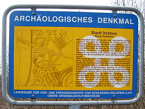
Esesfeld Castle
| Esesfeld | ||
|---|---|---|
|
Information sign near the former location |
||
| Alternative name (s): | Esesfelth, Esesfeldburg | |
| Creation time : | 809 ff. | |
| Castle type : | Niederungsburg | |
| Conservation status: | Burgstall, barely preserved | |
| Place: | Itzehoe | |
| Geographical location | 53 ° 56 '2.7 " N , 9 ° 28' 47" E | |
|
|
||
The castle Esesfeld (or Esesfelth even Esesfeldburg ) is an Outbound ring Wallenburg , in the year 809 by order of the Great Emperor Charles at the sturgeon was built. The origin of their name is not clearly established. Contrary to what was assumed until the second half of the 20th century, it is not identical to the Itzehoe Castle , which was built within the Störschleife and was only built around the year 1000 under the Billunger dukes .
history
According to the sources, Esesfeld Castle was the first Franconian fortification that was built north of the Elbe before Hammaburg . The occupation team settled there was commanded by the Saxon Count Egbert . From a military and political point of view, it functioned as a border fortress of the Frankish Empire in northern Albingia , which Karl had handed over to the Abodrites in 804 . Since this decision was reversed after the death of their velvet ruler Drasco in 810, the foundation of the castle is either to be seen as support for the Abodrites, allied with the Franks, or as the first step to bring the northern Elbe region to the Eider immediately under Franconian rule put. Together with the Hammaburg, the two fortifications created further conditions for missionary work in the area north of the Elbe. Also in the 9th century, a church was built nearby, the successor of which is the St. Marien Church in Heiligenstedten .
In the transition area between Geest and Marsch on a Geest ledge on the Oldenburgskuhle on today's western edge of Itzehoe to Heiligenstedten , the fortification was geographically located at the southwest end point of the Ochsenweg , the whole of Jutland and today's Schleswig-Holstein through the army and trade route, as well as the later than Lübsche Trade known trade route. At the same time, on the north side, it dominated the connection across the Elbe to Stade over the rivers Stör - Elbe - Schwinge . Due to the ferry passage supported by the rising and flowing water of the tide , this was one of the main crossings of the Lower Elbe at a time when waterways were the most important traffic arteries until the Elbe bridges were built in Hamburg .
The castle covered an area of about one hectare and was surrounded by a 6 m high earth ring wall, which in turn was preceded by a moat. In 817 the castle withstood an attack by the Danes and Abodrites; the attackers withdrew after an unsuccessful siege.
Excavations
In the 19th and 20th centuries, the Carolingian fort fell victim to sand and gravel excavations, the construction of the (later slightly relocated) route of the march railway and road construction; only a few remains of the moat are visible.
Scientific knowledge was only collected in the 20th century: the first explorations were carried out in the 1920s by Hermann Hofmeister and in 1952 by Herbert Jankuhn . At the instigation of Jankuhn, search pits were laid out by Konrad Weidemann in 1958 and 1959 . In 1974 additional excavations followed by the State Office for Prehistory and Early History. From 1977 further excavations were carried out by Gottfried Schäfer.
literature
- Hermann Hofmeister : Badenfliot and Esesfeld. In: Ders., District Committee of the Steinburg District (Hrsg.): Altsachsenforschung. Volume 1: Urholstein. JJ Augustin , Glückstadt 1932, pp. 111–123.
- Wilhelm Jensen: Where was the Karolingerburg in Itzehoe? , in: Die Heimat 42 (1932), pp. 49–53.
- Otto Scheel: On the "Urholstein" problem , in: ZSHG 63 (1935), pp. 1-65.
- Konrad Weidemann : A fortress from Carolingian times near the "Oldenburgskuhle" in Itzehoe . In: Steinburger Jahrbuch 1959, pp. 7-13.
- Gottfried Schäfer: Archaeological investigations at the "Oldenburgskuhle" in Itzehoe 1977 . In: Die Heimat 85, 1978, pp. 331–334.
- Gottfried Schäfer: Archaeological investigations at the "Oldenburgskuhle" in Itzehoe 1978 and 1979 . In: Die Heimat 87, 1980, pp. 351–355.
- Dirk Lornsen : A Carolingian base in the north. Excavations in Esesfeld Castle an der Stör , in: Archäologie in Deutschland , Vol. 1 (1987), pp. 36 to 39.
- Helmut Willert: The Esesfeld Fort. A castle in the border area of the Frankish Empire. The early history and the foundation of the city of Itzehoe . In: Stadt Itzehoe (ed.): Itzehoe. History of a city in Schleswig-Holstein . Volume 1: From early history to 1814 . Stadt Itzehoe, Itzehoe 1988, pp. 7-9.
Individual evidence
- ↑ Wolfgang Laur : Historisches Ortsnamelexikon von Schleswig-Holstein , 2nd edition, Neumünster 1992, p. 240: "Feld des Asi" or "Esi"; "Dry field"; “Bei See Esi”, possibly related to a lake-like extension of the sturgeon.
- ↑ See for example Otto Neumann: "Borchwurten" in the Störniederung , in: Die Heimat 62 (1955), p. 247. Previously about Detlef Detlefsen : The beginnings of Itzehoe , in: ZSHG 40 (1910), p. 326 f.
- ↑ See also Arno Jenkis: The incorporation of “Northern Albingia ” into the Franconian Empire , in: ZSHG 79 (1955), p. 81 to 104 (especially p. 93 f.).
- ↑ Dieter Hägermann : Charlemagne. Rowohlt, Reinbek bei Hamburg 2003, p. 44.


