
Falkenseebach
| Falkenseebach | ||
 The Falkenseebach in Inzell |
||
| Data | ||
| Water code | DE : 184821 | |
| location |
Bavaria
|
|
| River system | Danube | |
| Drain over | Rote Traun → Traun → Alz → Inn → Danube → Black Sea | |
| source | southwest of the Falkensee 47 ° 44 ′ 30 ″ N , 12 ° 45 ′ 43 ″ E |
|
| Source height | approx. 720 m above sea level NHN | |
| confluence | with the Großwaldbach to the Roten Traun Coordinates: 47 ° 45 ′ 50 " N , 12 ° 45 ′ 9" E 47 ° 45 ′ 50 " N , 12 ° 45 ′ 9" E |
|
| Mouth height | approx. 690 m above sea level NHN | |
| Height difference | approx. 30 m | |
| Bottom slope | approx. 6.6 ‰ | |
| length | 4.6 km | |
| Catchment area | 5.617 km² | |
| Flowing lakes | Falkensee | |
The Falkenseebach is the left source brook of the Roten Traun in Upper Bavaria .
The name Marterbach or Mahderbach can be found in old documents .
course
The Falkenseebach rises about 600 m southwest of the Falkensee between Falkenstein (1181 m) and the Großer Turm (1120 m) in several springs in the nature reserve Eastern Chiemgau Alps. It flows through the Falkensee and runs in the Weittal to the northeast. Before Inzell it bends to the west and unites with the more watery Großwaldbach to the Roten Traun .

Confluence of the Falkenseebach (front) and Großwaldbach (right) to the Roten Traun (left)
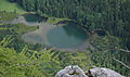
Falkensee from the summit of the Falkenstein, view in east direction.


The Weißbach, which drains via Saalach and Salzach, rises just a good 200 meters south of the Falkenseebach.
Web links
Individual evidence
- ↑ a b Google Earth
- ↑ Directory of stream and river areas in Bavaria - Inn river area of the Bavarian State Office for the Environment, as of 2016 (PDF; 2.8 MB)
- ↑ Map of the catchment area for the basic data on Bavarian rivers, Bavarian State Office for the Environment
- ^ Adolf Schaubach : The German Alps. A manual for travelers through Tyrol, Austria, Steyermark, Illyria, Upper Bavaria and the adjacent areas. Volume 3: Salzburg, Upper Styria, the Austrian Mountains and the Salzkammergut. Frommann, Jena 1865, p. 321 ( digitized version ).
- ↑ Land map , Bavarian first recording (1808–1864) in the BayernAtlas