
Falzer head
| Falzer head | ||
|---|---|---|
 Falzer Kopf with Diedamskopf (2090 m) from Kreuzmandl (1974 m) |
||
| height | 1968 m above sea level A. | |
| location | Vorarlberg , Austria | |
| Mountains | Northwestern Walsertal Mountains , Allgäu Alps | |
| Dominance | 1.8 km → Kreuzmandl | |
| Notch height | 123 m ↓ Neuhornbachjoch | |
| Coordinates | 47 ° 19 '53 " N , 10 ° 2' 59" E | |
|
||

The Falzer head (also Falzerkopf ) is a 1968 m above sea level. A. high mountain in the Allgäu Alps in the Austrian state of Vorarlberg .
Location and surroundings
The mountain , located in the sub-group Northwest Walsertal Mountains , rises from the ridge that runs from the Diedamskopf (2090 m) to the southeast to the Grünhorn (2039 m). The direct mountain neighbor in the north-west is the Diedamskopf, from which the Falzer Kopf is separated by the Diedsattel (1800 m). In the east the ridge runs over the Neuhornbachjoch (1845 m) to the Kreuzmandl (1974 m). In the north there is a small plateau where the source streams of the Subersach unite. To the southwest the flanks fall into the valley of the Bregenzer Ach and thus into the Bregenzerwald .
The district on which the Falzer Kopf is located is Schoppernau (852 m), which lies at the foot of the southwest flank. The border to the northern municipality of Bezau also runs over the mountain .
Ascent
The base for ascent of the Falzer Kopf is the Neuhornbachhaus (1650 m), which is located on the southeast ridge of the mountain. The Schwarzwasserhütte (1620 m) and the cable car to the Diedamskopf can also be found in the vicinity .
summer
The normal route from the Neuhornbachhaus goes over the Neuhornbachjoch and the east ridge to the highest point. The Neuhornbachjoch can also be reached from the Schwarzwasserhütte, the Schönenbach and Schoppernau pass. Another ascent option leads on various hiking trails from the lift area on the Diedamskopf to the west flank and from there to the west shoulder with the summit cross, called "Kreuzle". The last stretch to the summit is on a path on the grassy west ridge. Another variant is the ascent of the north-northwest ridge on an old, abandoned route. This is surefootedness , head for heights and climbing skills between the I and II. Degree necessary.
winter
The Falzer Kopf can also be climbed on a ski tour in winter . Routes can be found both from the Gerachsattel (1752 m) in the north flank and in the south flanks from the Neuhornbachhaus. Access from the Diedamskopf ski area in the west is also possible. There is also a chair lift for the ski area on the western flank .
gallery

South side of the Hochkünzelspitze (2397 m)

West flank with chairlift
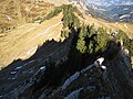
On the north ridge

Summit cross on the west shoulder


Web links
Individual evidence
- ^ Federal Office for Metrology and Surveying Austria: Austrian Map online (Austrian map 1: 50,000) . Retrieved January 24, 2012.
- ↑ Dieter Seibert: Alpine Club Guide alpine - Allgäu Alps and Ammergau Alps . 17th edition. Bergverlag Rother, Munich 2008, ISBN 978-3-7633-1126-2 (p. 172).
- ↑ Kristian Rath: Allgäu ski tour guide with Kleinwalsertal and Tannheimer Tal . 6th edition. Panico Alpinverlag, Köngen 2009, ISBN 978-3-9367-4010-3 (p. 33).
- ↑ Anton Kempf, Rainer Kempf: Bregenzerwald ski tour guide including the Great Walsertal and Lechquellen Mountains . 2nd Edition. Panico Alpinverlag, Köngen 2006, ISBN 978-3-9367-4012-7 (p. 96).