
Kreuzmandl
| Kreuzmandl | ||
|---|---|---|
 Steinmandl (1982 m) and Kreuzmandl vom Falzer Kopf |
||
| height | 1974 m above sea level A. | |
| location | Vorarlberg , Austria | |
| Mountains | Northwestern Walsertal Mountains , Allgäu Alps | |
| Dominance | 0.5 km → Steinmandl | |
| Notch height | 54 m ↓ notch to Steinmandl | |
| Coordinates | 47 ° 19 '47 " N , 10 ° 3' 51" E | |
|
||
| rock | Flysch of the Üntschendecke | |

The Kreuzmandl is a 1974 m above sea level. A. high mountain peak in the Allgäu Alps in the Austrian state of Vorarlberg .
Location and surroundings
The mountain , located in the sub-group Northwest Walsertal Mountains , rises from the ridge that runs from the Diedamskopf (2090 m) to the southeast to the Grünhorn (2039 m). The direct mountain neighbor to the west is the Falzer Kopf (1968 m), from which the Kreuzmandl is separated by the Neuhornbachjoch (1845 m). To the northeast the ridge runs over a notch to the Steinmandl (1982 m). This notch is the reference for the notch height of at least 54 meters. In the north there is a small plateau where the source streams of the Subersach unite. To the south the flanks drop into the valley of the Schreckbach , above which the Üntschenspitze (2135 m) rises .
The district on which the Kreuzmandl is located is Schoppernau (852 m), which is located southwest in the valley of the Bregenzer Ach . The border to the northern municipality of Bezau also runs over the mountain .
Ascent
The base for an ascent of the Kreuzmandl is the Neuhornbachhaus (1650 m), which stands on the southeast ridge of the Falzer Kopf. The Schwarzwasserhütte (1620 m) and the cable car to the Diedamskopf can also be found in the vicinity .
The normal route from the Neuhornbachhaus goes over the Neuhornbachjoch and the West Ridge to the highest point. The Neuhornbachjoch can also be reached from the Schwarzwasserhütte, the Schönenbach and Schoppernau pass. Another ascent option leads from the lift area on the Diedamskopf via the Falzer Kopf to the Neuhornbachjoch. The ridge crossing from the Steinmandl is also possible. This is partially insured with wire rope and requires surefootedness , a head for heights and climbing skills of the 1st degree .
gallery
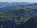
South view from the Hochkünzelspitze (2397 m)
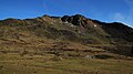
Southwest flank
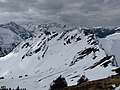
From the Steinmandl

With a connecting ridge and Steinmandl


Web links
Notes and individual references
- ↑ Ernst Zettler, Heinz Groth: Alpine Club Guide - Allgäu Alps. 12th, completely revised edition. Bergverlag Rudolf Rother, Munich 1985, ISBN 3-7633-1111-4 (p. 512).
- ↑ Exact value not known, stated value is a minimum value (can be up to 19 meters higher). It was determined from the distance between the contour lines (20 meters in altitude ) on a topographic map ( scale 1: 25,000).
- ↑ Dieter Seibert: Alpine Club Guide alpine - Allgäu Alps and Ammergau Alps . 17th edition. Bergverlag Rother, Munich 2008, ISBN 978-3-7633-1126-2 (p. 171 f).