Farsley
| Farsley | ||
|---|---|---|
| Town Street | ||
| Coordinates | 53 ° 49 ′ N , 1 ° 40 ′ W | |
|
|
||
| administration | ||
| Post town | PUDSEY | |
| ZIP code section | LS28 | |
| prefix | 0113 | |
| Part of the country | England | |
| region | Yorkshire and the Humber | |
| Metropolitan county | West Yorkshire | |
| Metropolitan Borough | City of Leeds | |
| British Parliament | Pudsey | |
Farsley is a town in the Metropolitan Borough of the City of Leeds , West Yorkshire , England , which is part of the Ward Calverley and Farsley . It was part of the Municipal Borough of neighboring Pudsey until 1974 and forms with this, Calverley , Horsforth and Guiseley a parliamentary constituency.
geography
Farsley is 6 miles (9 km) west of Leeds city center and 4 miles (6 km) east of Bradford , north of the main road that connects the two major cities. Neighboring towns are (clockwise) Rodley , Bramley , Pudsey, Thornbury and Calverley.
The approximate boundaries of the place are formed by the valley of the Farsley Beck to the east, by the road between Leeds and Bradford to the south, by the Leeds Outer Ring Road to the west and by Coal Hill to the north . The terrain slopes down from south to north.
history
In the Domesday Book of 1086 the place is mentioned as Fersellei (a) .
The Anglican clergyman Samuel Marsden was probably born in Farsley in 1765.
In the course of the Industrial Revolution , Farsley became a center for wool processing with numerous factories.
During the First World War, a makeshift airfield for military aircraft was set up on the outskirts of the village in April 1916, mainly on the site of what is now Farsley Farfield Primary School, but it was abandoned in March 1917 in favor of agricultural use.
From 1937 to 1974 the place belonged together with Calverley to the Municipal Borough of Pudsey and then came to the Metropolitan Borough of Leeds.
traffic
The main road between Leeds and Bradford runs on the southern edge of Farsley as the B6157. The B6156 to Calverley runs through the town from south to north, initially as Old Road and Town Street . The Leeds Outer Ring Road A6120 passes to the west of the town center .
The nearest train station is New Pudsey, about 1.2 km south of town center, on the Calder Valley Line with connections to Leeds, Bradford, Halifax , Huddersfield , York , Manchester and Blackpool .
In public transport , Farsley is served by bus routes to Leeds, Pudsey, Horsforth , Seacroft , Bradford and Halifax.
economy
Several factory buildings that are now used by other trades still bear witness to the once dominant wool processing.
Most of Farsley's shopping and pubs are along Town Street . At its lower end is The Fleece, the second pub ever acquired by Joshua Tetley's & Son and the oldest preserved of these. Four of the former eleven pubs in Farsley have been preserved, but several bars and restaurants have opened.
Other shopping options are in neighboring Pudsey, including ASDA and Marks and Spencer at the Owlcotes Center in Stanningley .
Farsley can now be seen as a commuter community oriented towards these cities due to its location between Leeds and Bradford .
education
Farsley has three elementary schools: Farsley Farfield Primary School for students ages 3-11, Westroyd Infant School (ages 3 to 7), and Farsley Springbank Junior School (ages 7-11). Priesthorpe School is the closest secondary school with over 1100 students.
Sports
Farsley Celtic Football Club, the successor to the Farsley Celtic Association Football Club, which was dissolved in 2010, is currently (2015) playing in the Northern Premier League with its stadium in Throstle Nest .
Farsley Cricket Club, with its cricket ground in Red Lane, plays in the 1st Division of the Bradford Cricket League (2015).
Architecture and landmarks
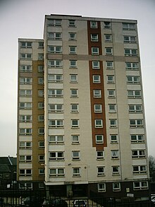
Along and in the vicinity of the Town Street are mainly older, mostly from sandstone built row houses , which in some streets back to back were built. Near the center of the town there is a council estate made up of apartment blocks , the highest of which has 12 floors. In the western part of the village there are mostly brick- built semi-detached houses and terraced houses, many of which were acquired by private owners, and on the outskirts there are also single- family houses .
Sheephead Park, west of Town Street, is dedicated to the memory of Samuel Marsden.
St. John's Church, the Anglican parish church, was built in 1842. Opposite it is the old schoolhouse that has been converted into apartments.
Personalities
- Samuel Marsden (1765–1838), clergyman, missionary in Australia and New Zealand, introduced sheep breeding in New Zealand
Web links
Individual evidence
- ^ Ward maps . Leeds City Council. 2013.
- ↑ Australian and New Zealand sources mostly give Farsley as the place of birth (cf. Australian Dictionary of Biography: Marsden, Samuel .), British sources also Horsforth (cf. Samuel Marsden, Apostle of New Zealand .).
- ^ Farsley . 2011.
- ^ Farsley Farfield Primary School . Retrieved July 28, 2015.
- ↑ Westroyd Infant School and Nursery . Retrieved July 28, 2015.
- ^ Farsley Springbank Junior School . Retrieved July 28, 2015.
- ^ Priesthorpe School . Retrieved July 28, 2015.


