Ferlo (river)
| Ferlo | ||
|
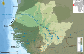
The Ferlo in the Senegal catchment area (top left) |
||
| Data | ||
| location |
|
|
| River system | Senegal | |
| Drain over | Senegal → Atlantic | |
| Headwaters | 27 km southwest of Bakel 14 ° 45 ′ 40 ″ N , 12 ° 39 ′ 53 ″ W |
|
| Source height | approx. 90 m | |
| muzzle | at Richard Toll coordinates: 16 ° 28 '12 " N , 15 ° 41' 33" W 16 ° 28 '12 " N , 15 ° 41' 33" W |
|
| Mouth height | 2 m | |
| Height difference | approx. 88 m | |
| Bottom slope | approx. 0.14 ‰ | |
| length | approx. 620 km | |
| Catchment area | 65,000 km² | |
| Flowing lakes | Guiers lake | |
The Ferlo is a river in the West African state of Senegal . He is the namesake for the Ferlo , one of the largest natural ecological geographic areas in the country.
geography
The Ferlo is the left southern tributary of Senegal in the north and northeast of Senegal in the area of the rain-poor Sahel zone . Its catchment area is in the Matam , Louga and Saint-Louis regions . In the dry season, the Ferlo only has water in the lower reaches.
The Ferlo rises in the southeast of the Matam region near the 100 m high step that forms the watershed to Senegal , which flows past just 27 kilometers to the northeast . The source river with the longest valley path and at the same time the furthest from the mouth (375 kilometers as the crow flies) starts east of Senoye and 27 kilometers southwest of the city of Bakel on the banks of Senegal . The headwaters are located at an approx. 90 m high valley head .
The valley path follows a general west-northwest direction until it reaches the southern end of the elongated Lac de Guiers . At its northern end, 50 kilometers away, the water of the Ferlo covers the last 16 kilometers up to the confluence with Senegal in a canalised bed. This stretch of water is known under the name Tahouey .
The upper reaches of the Ferlo runs through an area without any significant settlement. The first well-known village in the valley floor is Oudalaye , which was apparently newly laid out at km 184 and whose straight village streets form an almost chessboard-like pattern. The department prefecture Ranérou is then the first town that the valley path passes at kilometer 236. Here the Ferlo is strengthened from the right by the Vallée du Loumbol with its heavily greened valley floor in a vegetation that is otherwise becoming increasingly sparse when viewed from the source area. As the next town, the Ferlo reaches the Linguère department prefecture at kilometer 416 . At kilometer 456 it goes around the village of Yang-Yang , the seat of an arrondissement. From the village of Mboula at kilometer 475, the valley floor shows the first signs of a year-round water flow from a satellite perspective . In the village of Keur Momar Sarr , the seat of an arrondissement, the Ferlo has grown like a lake to around 2000 meters wide and here at kilometer 551 it bends at a right angle to the north to begin its path through the Lac de Guiers .
traffic
The national road N 7 , which can only be addressed as a dust track , which leads from Ourossogui in the north to Tambacounda in the south, crosses the dry valley of the Ferlo near Oudalaye . The N 3 leads on the way from Ourossogui in the east to Touba , Diourbel and Thiès in the west at Ranérou without any structures through the river bed. From here to Linguère , the N3 follows the valley at a certain distance and crosses the valley floor twice more: at Loumbel Lana there is a 900-meter-long dam bridge construction through the dry valley and at Linguère there are ducts under the asphalt road. At Keur Momar Sarr there is the most complex crossing of the continuous water flow, which is already wide here, with a 1,100 meter long dam bridge construction. In Richard Toll's urban area, a 70-meter-long bridge for the N 2 spans the canalised runoff into Senegal.
Individual evidence
- ↑ Source height according to OpenCycleMap
- ↑ Measure distances with google maps (approx. 625 measuring points)
- ↑ Catchment area calculated from the difference between the information on Dagana and Richard Toll according to the monograph, rounded down to 1,000, pages 317 and 322 of the PDF file
- ↑ Senoye in Geonames
- ↑ Taoué at Geonames
- ↑ Vallée du Loumbol at Geonames
