
Fortress belt Kreuzlingen

The fortress belt of Kreuzlingen (older name: Werkgürtel Kreuzlingen ) was a border fortification of the Swiss Army to secure the land border between the German city of Konstanz and the Swiss city of Kreuzlingen . The fortifications were built from 1937, were used until the 1990s and are considered to be military-historical monuments of national importance.
Political and geographical situation
In the 1920s, Switzerland was threatened primarily by France and Italy , which were among the victorious powers of the First World War . After the transfer of power to the National Socialists in Germany , in September 1933 the international press discussed a «fortification gap in Switzerland», pointing out that Germany could attack France via Swiss territory in order to circumvent the Maginot Line emerging on the French eastern border . This possibility had already in 1932 the Nazi military theorist Ewald Banse in his work space and people in World War II mentioned. After the occupation of the Rhineland , the "Anschluss" of Austria and the arming of the Wehrmacht , Switzerland saw Germany as its greatest military threat at the end of the 1930s.
With the Upper Rhine , the Seerhein and the Lower and Upper Lakes of Lake Constance , the Swiss border with Germany largely follows waters that represent a natural obstacle. The only area in which the border south of the water chain runs overland is the section between the city center of Konstanz and the town of Kreuzlingen in the canton of Thurgau, which is directly on the border . Constance and parts of Kreuzlingen are on the same level that borders on Lake Constance. To the south is the Seerücken , which here reaches heights of 150 meters above the water level of Lake Constance. The northern slope of the ridge is divided by several creek valleys that reach depths of up to 30 meters. At the height of the ridge of the lake, forests predominate, through which five roads and a railway line lead from Kreuzlingen to the south.
From a military point of view, the border line, together with the Constance Rhine Bridge, forms a bridgehead that is particularly suitable for an attack on Switzerland, as it is not necessary to cross bodies of water and the terrain is suitable for the use of tanks . An attack via the Seerücken to the south was considered particularly likely, as the Romanshorn - Winterthur axis and thus the greater Zurich area can be reached.
Planning and construction


In 1934 the Swiss army command decided to fortify the northern border. In July 1935 an engineering officer course explored an 11.5 kilometer long defensive position in the area around Kreuzlingen, which was built with some modifications from 1937. The defensive position begins on the banks of the Obersee near Bottighofen ⊙ and runs behind a creek to the south to Lengwil ⊙ . From here the position follows the Seerücken via Bätershausen ⊙ and Weiherhau ⊙ westwards, bends north at the Staudenhof ⊙ and, again running behind a creek, reaches the shores of the Untersee at Triboltingen ⊙ .
When determining the defensive position, it was assumed that a defense in the built-up area of Kreuzlingen would hardly be feasible. The main line of defense should be arranged on the sea ridge in such a way that it was not visible to the attacker. There were also plans to build several artillery works to be used against the south of Constance, the Rhine bridge there and attacking infantry . Roadblocks should be prepared against tank attacks. The defensive position should be equipped with bunkers , whereby a distinction was made between works and stands. Works and stands were designed to be the same in terms of their external resilience, but differed in their equipment: Works were intended for the crew to stay for several days, while for stands it was assumed that the crew would be replaced every day.
The construction of the fortress belt was part of the construction program for border fortifications that was submitted to the Federal Military Department for approval in February 1937. The plan was to build six bunkers equipped with infantry cannons, as well as 42 additional stands for machine guns . The planned artillery works were canceled; instead, two mobile batteries should be used. The costs were estimated at 5.9 million francs . Great importance was attached to the construction of the Kreuzlingen factory belt, as it should be carried out in full, even with any savings measures.
Construction began in June 1937. At the same time as the bunker was being built, a sapper battalion erected tank obstacles. The construction of the factories and stands was delayed and could not be completed in 1937, as originally planned. One cause of the delays were problems with the procurement of armor plates that were needed for the loopholes . Attempts by Swiss companies to manufacture armor plates did not yield satisfactory results, so products from the German Krupp factories were used. Due to some rescheduling, the number of bunkers was reduced to 42; the last ones were completed in June 1940.
use
Just before the German invasion of Poland , the 7th Border Brigade was mobilized on August 29, 1939. The locking points of the fortress belt were ready for defense after an hour and a half; after another half a day the battalions were fully engaged. The Border Brigade 7 belonged to special border guards that had been set up in the 1930s; the brigade was responsible for the border on the Upper and Lower Lakes. According to the defense concept valid in 1939, the fortress belt should delay an enemy attack by four to six days . This was to prevent a quick occupation of the Swiss plateau , which was of great importance for the full mobilization of the Swiss army .
The location and construction of the Kreuzlingen factory belt were known to the German armed forces . German plans for an attack on Switzerland, which were developed as Operation Tannenbaum from June 1940 , included an attack by the 262nd Infantry Division from Constance . Parts of the division were supposed to cross Lake Constance from Friedrichshafen to Romanshorn and attack the fortification from behind.
In the course of the Second World War , the Kreuzlingen factory belt lost its importance: Jakob Labhardt , commander of the 4th Army Corps, which was also responsible for Kreuzlingen, no longer considered the fortification as important as it had been when it was built. Labhardt referred to the fact that the factory belt could be bypassed and pleaded for no more large investments to be made. In 1940 the border brigade's request for credit for fortifications was handled hesitantly; In 1942, the brigade was no longer granted a loan. Instead, the factory belt was expanded by Border Brigade 7 itself: 40 additional bunkers were built; they differ from the older systems in that they have less wall thickness. In addition, the tank barricades were strengthened and an infantry barrier almost continuous from Triboltingen to Bottighofen was built.
After the end of the Second World War, the fortress belt continued to be used during the Cold War . The facilities, especially the road blocks and terrain obstacles, were renewed and expanded. In the 1960s, the combat value of the fortress belt was improved by the 9 cm anti-tank gun 57 . In the 1970s, numerous ASUs ( atomic protection shelters ) and in the 1980s and 1990s the 12 cm fortress mine throwers and terrain reinforcements in the southern brigade room. (E.g. Stichbach in Bottighofen expanded as a tank ditch , explosive object Lippoldswiler Tobel motorway bridge, motorway embankments on both sides of the A7 in the Oberstock area made impassable for tanks by boulders, tank barricades in the center of Weinfelden).
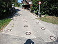
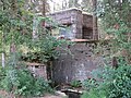
As part of the Army 95 concept , the Swiss Army largely abandoned the fortress belt in the 1990s. The fortress belt was included in the inventory of military monuments in the canton of Thurgau as a blocking point of national importance. The skilful camouflaging of individual bunkers was emphasized: Two plants in Triboltingen were camouflaged as half-timbered buildings . A bunker on the site of a sawmill in Lengwil gives the impression of a pile of wood. During the construction of Autobahn 7 , some bunkers were demolished. The canton of Thurgau took over several combat facilities in 1999. The Fortress Belt Association in Kreuzlingen looks after some buildings, organizes guided tours and has set up four military-historical hiking trails.
Command post
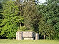
The "Erichstollen" command post, which was built in 1940 and expanded in 1962, was in charge of the defense of the Kreuzlingen fortress belt. The facility was designed for 100 men. It was declassified in 2005 and bought by the Kreuzlingen Fortress Belt Association in 2008 . The regimental command post "Ottoberg" type 76 concrete monoblock was built in 1986 in Ottoberg and modernized in 1999. It offered space for 60 men.
Partial closure of the Bottighofen
The factory belt consisted of around 79 facilities (combat facilities and shelters), today (2017) 66 are still available. Further systems to strengthen the fortress belt and the Wälti barrier were built during Army 61 (Army designation F XXXX). The Bottighofen barrier (Bottighofen lakeshore to Liebburg / Seerücken), with its 24 bunkers and 7 obstacles, had to prevent an opponent coming from Constance from breaking through eastwards along the shores of Lake Constance.
- Infantry bunker Chlii Rigi A 5691 ⊙
- Waldrüti Süd infantry bunker A 5692 ⊙
- Waldrüti Nord infantry bunker A 5693 ⊙
- Infantry bunker Hohgasse A 5694 ⊙
- Infantry bunker A 5695 ⊙
- Infantry bunker Obere Mühle A 5696 ⊙
- Infantry bunker Warrenberger A 5697 ⊙
- Rutishauser infantry bunker A 5698 ⊙
- Infantry bunker Bottighofen Strasse A 5700 ⊙
- Bottighofen-Dorf infantry bunker A 5701 ⊙
- Mine thrower observer Bottighofen A 5702 ⊙
- Infantry bunker Bottighofen Bahn A 5703 ⊙
- Bottighofen Ufer infantry bunker (demolished) A 5704 ⊙
- Infantry bunker Bellevue West A 5707 ⊙
- Infantry bunker Bellevue Ost A 5708 ⊙

Waldrüti South Infantry Bunker A 5692

Warrenberger A 5697 infantry bunker

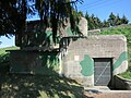
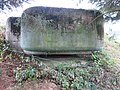
Anti-tank bunker Bottighofen Dorf A 5700, built in 1938
Waldrüti street barricade


Lengwil partial closure
The blocking point in Lengwil (Liebburgtobel to Lengwil train station) with its 25 bunkers and 9 tank barricades had to block the eastern approach and traffic axes across the flat Seerücken to the south.
- Pfaffenweiher Nord infantry bunker A 5680 ⊙
- Pfaffenweiher infantry bunker A 5681 ⊙
- Infantry bunker Lengwil embankment A 5683 ⊙
- Lengwil Infantry Bunker Station A 5684 ⊙
- Pak garage F 7260 ⊙
- Shelter A 5688 ⊙
- Shelter A 5689 ⊙
- Infantry bunker Liebburgtobel Ost A 5690 ⊙
- Company command post Liebburg F 7305 ⊙
- GPH T 3025 ⊙

Pfaffenweiher Nord infantry bunker A 5680, built in 1940
Anti-tank bunker Lengwil South Embankment A 5683

Infantry bunker (BBB) Lengwil Station A 5684, built in 1938

Company command post Liebburg F 7305


Partial closure of Bätershausen-Bernrain
The blocking points at Bätershausen, Castel and Wälti had to block the central and western approach and traffic axes across the Seerücken to the south. The Wälti barrier was created during Army 61.
- Eichhof infantry bunker A 5664 ⊙
- Weiherhau infantry bunker A 5665 ⊙
- Shelter / Bat-KP A 5666 ⊙
- Bernrain Süd infantry bunker (demolished) A 5667 ⊙
- Bernrain Nord infantry bunker (demolished) A 5668 ⊙
- Infantry bunker Bemstwies A 5669 ⊙
- Infantry bunker Bemstwies West A 5670 ⊙
- Infantry bunker Bemstwies Ost A 5671 ⊙
- Shelter A 5672 ⊙
- Infantry bunker Bätershausen West A 5673 ⊙
- Bätershausen Ost infantry bunker (demolished) A 5674 ⊙
- Infantry bunker Bätershausen West A 5675 ⊙
- Infantry bunker Bätershausen Ost A 5676 ⊙
- Shelter A 5677 ⊙
- Egghau infantry bunker A 5678 ⊙
- Shelter A 5679 ⊙
- GPH T 3025 ⊙

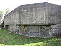
Anti-tank bunker Eichhof A 5664, built in 1940
Infantry bunker Bemstwies A 5669

Infantry bunker Bemstwies Ost A 5671

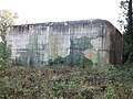
Egghau A 5678 infantry bunker, built in 1939


Partial closure Castel-Almänd
The Castel blocking point extended from the Lengwil train station to Castel and in its section had to block the access and traffic axes across the Seerücken to the south.
- Infantry bunker Allmendhau Süd A 5647 ⊙
- Shelter Glariszelghau A 5648 ⊙
- Infantry bunker Allmendtobel A 5649 ⊙
- Infantry bunker Glariszelghau Ost A 5650 ⊙
- Infantry bunker Glariszelghau West A 5651 ⊙
- Shelter Lindebühlhau A 5652 ⊙
- Infantry bunker Studenhof North A 5653 ⊙
- Ribiswieshaus shelter A 5654 ⊙
- Infantry bunker Studenhof Süd A 5655 ⊙
- Infantry bunker Allee A 5656 ⊙
- Infantry bunker Castel Höhenweg A 5657 ⊙
- Infantry bunker Castel Süd A 5658 ⊙
- A 5659 nursery shelter ⊙
- Infantry bunker Castel A 5660 ⊙
- Casteltobel West infantry bunker A 5661 ⊙
- Casteltobel West infantry bunker A 5662 ⊙

Infantry bunker Glariszelghau Ost A 5650
Infantry bunker Allee A 5656
Infantry bunker Castel Süd A 5658
Castel A 5660 infantry bunker

Off-road tank obstacle Eichhof T 3025


Partial closure of Triboltingen
The locking point Triboltingen (Castel to Triboltingen Seeufer) had to prevent an opponent coming from Constance from marching further west along the Untersee with 15 bunkers, 26 shelters and obstacles.
- Infantry bunker Triboltingen Bahn A 5630 ⊙
- Infantry bunker Triboltingen level crossing A 5631 ⊙
- Infantry bunker Triboltingen Brunnen A 5632 ⊙
- Infantry bunker Triboltingen Süd A 5633 ⊙
- Infantry bunker (broken off) A 5634 ⊙
- Infantry bunker Wiibergstöbeli West A 5635 ⊙
- Infantry bunker Wiibergstöbeli Ost A 5636 ⊙
- Triboltingen shelter, target stand A 5637 ⊙
- Infantry bunker Triboltingen Target position A 5638 ⊙
- Observer A 5640 ⊙
- Artillery observer Nonnenwis A 5641 ⊙
- Infantry bunker Nonnenwis A 5642 ⊙
- Infantry bunker Allmendhau Nord A 5643 ⊙
- Infantry bunker Allee A 5644 ⊙
- Bannholz shelter A 5645 ⊙
- Bannholz infantry bunker A 5646 ⊙
- GPH T 3025 ⊙

Anti-tank bunker (BBB) Triboltingen Brunnen A 5632, built in 1938

Anti-tank bunker (BBB) Triboltingen Süd A 5633, built in 1938

Infantry bunker Wiibergstöbeli Ost A 5636
Artillery observation bunker Nonenwis A 5641, built in 1940


literature
- Peter Hofer: Planning and construction of the Kreuzlingen fortress belt. (= Series of publications by the Federal Military Library and the Historical Service , Volume 27), Federal Military Library (EMB) and Historical Service, Bern 2007, ISBN 3-906969-26-6 .
Web links
- Homepage of the fortress belt association Kreuzlingen
- Federal Department of Defense, Civil Protection and Sport (Ed.): Military monuments in the cantons of Schaffhausen and Thurgau. Inventory of the combat and command structures. (pdf, 6.2 MB)
- Bunker friends: facilities in the canton of Thurgau
- Thurgauer Zeitung of February 26, 2016: Military installation of national importance disguised as wood beige is to be destroyed
- Bunker of the fortress belt from above
- Historical aerial photographs (1939) of the Swiss national topography
Individual evidence
- ↑ Hofer, planning , p. 15f.
- ↑ Hofer, planning , pp. 17, 21.
- ↑ Hofer, planning , p. 45.
- ↑ Hofer, planning , p. 43.
- ↑ Hofer, planning , pp. 41f, 51.
- ↑ Hofer, planning , pp. 46, 49f, 56f.
- ↑ Hofer, planning , p. 54.
- ↑ Hofer, planning , pp. 56, 66f. The building program from February 1937 in facsimile (pdf, 864 kB) at the Kreuzlingen Fortress Belt Association.
- ↑ This assessment in Hofer, planning , p. 67.
- ↑ a b c work belt Kreuzlingen [1] In: Department, monuments , S. 26th
- ↑ Hofer, planning , pp. 68–70, 72, 75f.
- ↑ Hofer, planning , pp. 31f, 35f.
- ↑ Hofer, planning , p. 29f.
- ↑ Hofer, planning , pp. 23f, 85f.
- ↑ Hofer, planning , p. 80f.
- ↑ Hofer, planning , pp. 86–93.
- ↑ Maurice Lovisa: Explanations on the inventory of the combat and command structures in the cantons of Schaffhausen and Thurgau. [2] In: Departement, Denkmäler , p. 14.
- ↑ Hofer, planning , p. 91f.
- ^ Bottighofen locking point [3] . In: Departement, Denkmäler , pp. 32–33, here p. 33.
- ↑ Camouflages [4] In: Departement, Denkmäler , p. 38.