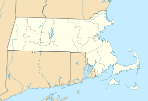
Fitchburg, Massachusetts
| Fitchburg | ||
|---|---|---|
 Coggshall Park, Fitchburg |
||
| Location in Massachusetts | ||
|
|
||
| Basic data | ||
| Foundation : | 1730 | |
| State : | United States | |
| State : | Massachusetts | |
| County : | Worcester County | |
| Coordinates : | 42 ° 35 ′ N , 71 ° 48 ′ W | |
| Time zone : | Eastern ( UTC − 5 / −4 ) | |
| Residents : | 39,102 (as of: 2000) | |
| Population density : | 543.8 inhabitants per km 2 | |
| Area : | 72.7 km 2 (approx. 28 mi 2 ) of which 71.9 km 2 (approx. 28 mi 2 ) is land |
|
| Height : | 143 m | |
| Postal code : | 01420 | |
| Area code : | +1 351,978 | |
| FIPS : | 25-23875 | |
| GNIS ID : | 0617121 | |
| Website : | www.ci.fitchburg.ma.us | |
| Mayor : | Lisa A. Wong | |
Fitchburg is a city in the northeast of the US state Massachusetts .
It belongs to Worcester County . It is said to be the second hilliest city in the United States after San Francisco . In 2000 39,102 people lived here.
history
The area around Fitchburg has been settled since 1730, the place was founded in 1764. It was named after the settler John Fitch, who was abducted by Indians to Canada with his family in 1748 and did not return until a year later.
Located on the railway line between Boston and Albany and on the North Nashua River , the city was able to develop into an industrial center in the 19th century . Watermills produced machines, tools, clothing and paper. Fitchburg is known for its Victorian- style buildings that were built around the time.
sons and daughters of the town
- Mortimer Mishkin (* 1926), neurophysiologist
- Art Longsjo (1931–1958), cyclist and speed skater. Longsjo had a fatal car accident at the age of 26. In his honor, the cycle race is since 1960 Fitchburg Longsjo Classic held, including the now four stages, is busy high class and will be held for men and women since the 1977th The winners include a. Lance Armstrong , Zach Bell , Tyler Hamilton , Sarah Ulmer and Sue Novara . In addition, there is a memorial to Art Ljongso in the village.
- David K. Wyatt (1937-2006), historian
- Wayne Berndt (* 1954), religious and Roman Catholic Bishop of Naha in Japan
- Amerie (* 1980), R&B singer and actress
Town twinning
Fitchburg entertains you with following cities twinning :
Web links
Individual evidence
- ↑ longsjo.com ( Memento of the original from December 25, 2011 in the Internet Archive ) Info: The archive link has been inserted automatically and has not yet been checked. Please check the original and archive link according to the instructions and then remove this notice.
