Vanderhoof Airport
| Vanderhoof Airport | ||
|---|---|---|
|
|
||
| Characteristics | ||
| ICAO code | No | |
| IATA code | No | |
| Coordinates | ||
| Height above MSL | 678 m (2224 ft ) | |
| Transport links | ||
| Distance from the city center | 2.4 km north of Vanderhoof | |
| Runways | ||
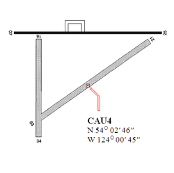
| 03/21 | 1585 m × 56 m grass / gravel | |
| 07/25 | 1529 m × 31 m asphalt | |
| 16/34 | 976 m × 56 m grass / gravel | |
The Vanderhoof Airport is a regional airport in the Canadian province of British Columbia . Airport identifier LID = CAU4
Planning
The airport is receiving $ 388,000 from the province of British Columbia for urgently needed investments . For this purpose, airfield lighting with approach lighting and a GPS- based approach system are to be purchased. These would also give the airport night flight capability.
Start-and runway
When approaching this airport, there are no navigation aids such as NDB or VOR .
- Runway 03/21, length 1585 m, width 54 m, grass / gravel
- Runway 07/25, length 1529 m, width 22 m, asphalt
- Runway 16/34, length 975 m, width 54 m, grass / gravel
service
The following types of aviation fuel are available at the airport:
Flight connections
Guardian Aerospace offers charter flights.
Web links
- Charter offers
- [Province of British Columbia]
Individual evidence
- ↑ Over $ 1 Million for Vanderhoof Area Roads and Airport. (No longer available online.) BC Ministry of Transportation and Infrastructure, July 8, 2008, formerly original ; accessed on February 13, 2013 . ( Page no longer available , search in web archives ) Info: The link was automatically marked as defective. Please check the link according to the instructions and then remove this notice.
- ↑ a b c Airport diagram. (PDF; 76.5 MB) In: NAV CANADA . Accessed April 6, 2018 .

