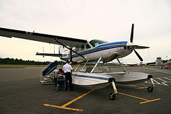
Campbell River Airport
| Campbell River Airport | |
|---|---|

|
|
| Characteristics | |
| ICAO code | CYBL |
| IATA code | YBL |
| Coordinates | |
| Height above MSL | 99 m (325 ft ) |
| Transport links | |
| Distance from the city center | 8.3 km south of Campbell River |
| Street | British Columbia Highway 19 |
| Basic data | |
| Flight movements |
30604 (as of 2010) |
| Start-and runway | |
| 12/30 | 1981 m × 46 m asphalt |
The Campbell River Airport is an international airport on Vancouver Iceland near the town of Campbell River , British Columbia , Canada . It is open 24/7 all year round. It is in the UTC-8 (DST-7) time zone.
Start-and runway
The following navigation and landing aids are available when approaching the airport: NDB , VOR / DME , ILS
- Runway 12/30, length 1980 m, width 45 m, asphalt.
The runway has a gradient of 0.88% (northwest end: Elev 357 ft, southeast end: Elev 298 ft)
service
Since the place is classified as an airport of entry and officials from the Canada Border Services Agency (CBSA) are stationed there, entry from abroad is permitted.
The following types of aviation fuel are available at the airport:
Flight connections
There are currently three regular flight connections to Vancouver , Port Hardy and Bella Bella with the airlines Pacific Coastal Airlines , Eagle Air and Central Mountain Air .
Incidents
- On September 17, 1969, a Convair CV-640 of Pacific Western Airlines ( aircraft registration number CF-PWR ) was flown into a hill three kilometers from the destination while approaching Campbell River Airport ( Vancouver Island ). The reason was flying an improvised, impermissible approach procedure in bad weather. In this CFIT, Controlled flight into terrain , 4 of the 15 occupants were killed, two crew members and two passengers.
Web links
Individual evidence
- ↑ Total aircraft movements by class of operation. Statistics Canada , December 19, 2012, accessed December 7, 2017 .
- ↑ Airport diagram. (PDF; 76.5 MB) In: NAV CANADA . Accessed April 6, 2018 .
- ^ Campbell River Airport. Canada Border Services Agency , February 4, 2014, accessed November 24, 2014 .
- ^ Accident report CV-640 CF-PWR , Aviation Safety Network (English), accessed on February 2, 2020.