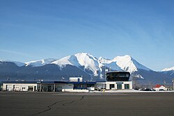
Smithers Airport
| Smithers Airport | |
|---|---|

|
|
| Characteristics | |
| ICAO code | CYYD |
| IATA code | YYD |
| Coordinates | |
| Height above MSL | 523 m (1716 ft ) |
| Transport links | |
| Distance from the city center | 2.5 km north of Smithers |
| Street | Highway 16 |
| Basic data | |
| opening | 1999 |
| operator | Smithers Town |
| Terminals | 1 |
| Flight movements |
9,494 (as of 2010) |
| Start-and runway | |
| 15/33 | 2299 m × 45 m asphalt |
Smithers Airport is a regional airport in the Canadian province of British Columbia . It has been owned by the City of Smithers since April 1, 1999 . It is located in the northeast part of the city and has an asphalt runway for light to medium-weight aircraft. Flights can be handled around the clock.
Start-and runway
The following navigation and landing aids are available when approaching the airport: NDB , VOR / DME , PAPI
- Runway 13/31, length 2299 m, width 45 m, asphalt
service
The following types of aviation fuel are available at the airport:
Flight connections
Hawkair flies to Vancouver once a day and Air Canada flies the same route twice a day. Central Mountain Air flies once a day to Prince George , Kamloops , Kelowna and Terrace . Central Mountain Air offers charter flights. Northern Thunderbird Air flies to Dease Lake several times a week . Highland Helicopters, Northern Thunderbird Air and Sustut Air offer charter flights.
Web links
Individual evidence
- ↑ Total aircraft movements by class of operation. Statistics Canada , May 5, 2011, accessed November 21, 2012 .
- ↑ Airport diagram. (PDF; 76.5 MB) In: Nav Canada . Accessed April 6, 2018 .