British Columbia Highway 19
| Highway 19 in British Columbia, Canada | |
| Vancouver Inland Island Highway | |

|
|
| Basic data | |
| Operator: | British Columbia Ministry of Transportation |
| Start of the street: |
Nanaimo ( 49 ° 10 ′ N , 123 ° 53 ′ W ) |
| End of street: |
Port Hardy ( 50 ° 43 ′ N , 127 ° 30 ′ W ) |
| Overall length: | 397 km |
| South end of the highway at Duke Point Ferry Terminal | |
|
Course of the road
|
|
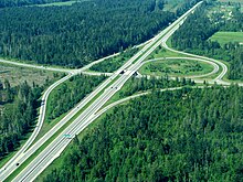
The British Columbia Highway 19 is a highway in British Columbia in Canada . In addition to its number, it also bears the official name Vancouver Inland Island Highway , but the name should not be confused with the Island Highway , which is then Highway 19A .
Highway 19 crosses Vancouver Island in a north-south direction and has a length of 397 km. It starts at the Duke Point Ferry Terminal in Nanaimo and ends at the Bear Cove Ferry Terminal at Port Hardy .
The highway is between Nanaimo and the intersection with Highway 4A , as a so-called core route , and between the intersection with Highway 4A and the intersection with Highway 28 , as the so-called feeder route , part of the Canadian National Highway System .
course
The highway begins at the Duke Point Ferry Terminal in eastern Nanaimo. It runs south for the first few kilometers and then meets Highway 1 and then follows north again. After two kilometers the highways separate again, Highway 1 runs along the coast of Departure Bay, Highway 19 follows north, west past Nanaimo. 46 km after the start of the highway, it leaves its originally built route. Expanded as a freeway, it leads as a local bypass as a so-called "Inland Island Highway" around the following coastal towns. The original highway continues to operate as Highway 19A . At Qualicum Beach, Highway 4 crosses , which leads to the west coast of Vancouver Island. In Campbell River , Highway 19 and Highway 19A will merge again after 123 km. Furthermore, Highway 28 branches off from there to the west.
At Bloedel the highway runs inland, but still runs largely parallel to the coastline. Along the Nimpkish Lake the highway leads back to the coast and runs along the coast again on its last part.
Shortly before Port Hardy, the highway branches off to the north and ends at the Bear Cove Ferry Terminal, from where the famous Inside Passage begins northwards along the coast of Canada and Alaska .
Individual evidence
- ^ Official Numbered Routes in British Columbia. Government of British Columbia, accessed December 4, 2018 .
- ↑ Landmark Kilometer Inventory (LKI). Government of British Columbia, accessed December 4, 2018 .
- ↑ Canada's National Highway System - Annual Report 2017. (PDF) Council of Ministers Responsible for Transportation and Highway Safety, accessed on August 28, 2019 .

