British Columbia Highway 23
| Highway 23 in British Columbia, Canada | |||||||||||||||||||||||||||||||||||||||||||
| Nakusp - Mica Creek | |||||||||||||||||||||||||||||||||||||||||||

|
|||||||||||||||||||||||||||||||||||||||||||
| Basic data | |||||||||||||||||||||||||||||||||||||||||||
| Operator: | British Columbia Ministry of Transportation |
||||||||||||||||||||||||||||||||||||||||||
| Start of the street: |
Nakusp ( 50 ° 15 ′ N , 117 ° 48 ′ W ) |
||||||||||||||||||||||||||||||||||||||||||
| End of street: |
Mica Dam ( 52 ° 5 ′ N , 118 ° 33 ′ W ) |
||||||||||||||||||||||||||||||||||||||||||
| Overall length: | 246 km | ||||||||||||||||||||||||||||||||||||||||||
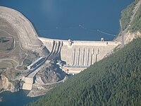
| Revelstoke Dam, Highway 23 on the right | |||||||||||||||||||||||||||||||||||||||||||
|
Course of the road
|
|||||||||||||||||||||||||||||||||||||||||||

The British Columbia Highway 23 in British Columbia, Canada , has a length of km 246th It begins in Nakusp , runs the entire route along the Columbia River before it ends at the Mica Dam on Kinbasket Lake .
Route
The highway begins in Nakusp as a junction of Highway 6 . It runs north along the eastern shore of Upper Arrow Lake . Highway 31 branches off at Galena Bay . Shortly after Highway 31 branches off, Highway 23 meets Upper Arrow Lake and is interrupted by the ferry service from Galena Bay to Shelter Bay. The ferry service is part of the highway and, as with all British Columbia domestic ferries, is free of charge. On the west side of the lake, the highway continues at Shelter Bay and shortly thereafter passes Arrow Lakes Provincial Park . Halfway through the 50 km to Revelstoke , you will pass Blanket Creek Provincial Park . Highway 1 is crossed in Revelstoke . Highway 23 continues north, but again along the east bank of the Columbia River. The Revelstoke Dam , which is located directly on Highway 23, follows 5 km north of Revelstoke . North of the dam is Revelstoke Lake , east of the highway is Mount Revelstoke National Park . There are no other places along the highway apart from the village of Mica Creek just before the end of the route . The highway ends 151 km north of Revelstoke at Mica Dam.
Individual evidence
- ^ Official Numbered Routes in British Columbia. Government of British Columbia, accessed December 4, 2018 .
- ↑ Landmark Kilometer Inventory (LKI). Government of British Columbia, accessed December 4, 2018 .
- ^ Upper Arrow Lake Ferry. Government of British Columbia, accessed December 4, 2018 .
