
Frankenalb Panorama Trail
| Frankenalb Panorama Trail | |
|---|---|
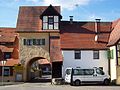
 Lichtenegg castle ruins |
|
| map | |
.png)
|
|
| Data | |
| length | 51.3 km |
| location | Germany , Bavaria |
| Markers |
|
| Starting point |
Lichtenegg castle ruins 49 ° 28 ′ 50.6 ″ N , 11 ° 35 ′ 41.3 ″ E |
| Target point |
Lichtenegg castle ruins 49 ° 28 ′ 50.6 ″ N , 11 ° 35 ′ 41.3 ″ E |
| Type | Long-distance hiking trail |
| The highest point | Deckersberg reservoir ( 591 m ) |
| Lowest point | Happurg ( 357 m ) |
| particularities | Prädikatswanderweg |

The Frankenalb-Panoramaweg (formerly Ulrich-von-Königstein-Weg) is a 51.3 kilometer long hiking trail through the Franconian Alb .
Route
Lichtenegg - Waizenfeld - Mittelburg - Wasserhaus am Hochberg - Johannesburg - Arzlohe - Hohler Fels - Happurg - Hochspeicher - Jungfernsprung - Deckersberg - Prosberg - Engelthal - Peuerling - Buchenberg - Steinerne Rinne am Buchenberg - Schrotsdorf - Egensbach - St. Ottmar and St. Ottilien chapel ruins - Kucha - Oberndorf - Hinterhaslach - Mosenhof - Kainsbach - Reicheneck - Förrenbach - Arzlohe - Lichtenegg.
The exact course of the route can be found in OpenStreetMap .
Directions
The route is characterized by the particularly high proportion of natural paths and sights. Quiet plateaus with wide views alternate with dark spring areas and defiant castles. In addition to striking ascents and descents, the path has easy passages. Large parts of the route are congruent with the Frankenweg and Main-Donau-Weg (Jura line). The path is supervised by the Franconian Alb Association . The hiking trail was originally named after Ulrich von Königstein, a knight and ministerial officer who worked in this area. He was a faithful servant of the emperor (Hohenstaufen) and founded the Engelthal monastery in 1240 after the death of his son . In 2014 it was renamed the Frankenalb Panorama Trail.
Waymarking
The path is marked with a vertical red bar on a yellow background (see info box).
Award
The German Hiking Association has examined the trail in 2010 and it the predicate Qualitätsweg Walking in Germany awarded.
gallery

Chapel ruin to the holy tree near Arzberg

Happurger reservoir in winter
Engelthal

Chapel ruins St. Ottmar and St. Ottilien near Offenhausen

Stone channel on Buchenberg


Individual evidence
- ↑ Openstreetmap: Frankenalb Panorama Trail
- ^ Fränkischer Albverein, Frankenalb-Panoramaweg (accessed on February 10, 2013)
- ↑ Press release of the German Hiking Association. wanderbaren-deutschland.de, January 14, 2010, accessed on October 8, 2012 (PDF, 66 kB).