Freebach
| Freebach | ||
|
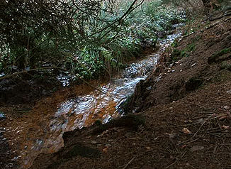
Right inlet of the Freebach in the nature reserve of the same name, |
||
| Data | ||
| Water code | DE : 2768882 | |
| location | North Rhine-Westphalia , Germany | |
| River system | Rhine | |
| Drain over | Heilenbecke → Ennepe → Volme → Ruhr → Rhine → North Sea | |
| source | At Ennepetal - barrier 51 ° 14 ′ 49 ″ N , 7 ° 21 ′ 23 ″ E |
|
| Source height | 344 m above sea level NN | |
| muzzle | In the Heilenbecker Dam Coordinates: 51 ° 15 ′ 4 " N , 7 ° 22 ′ 15" E 51 ° 15 ′ 4 " N , 7 ° 22 ′ 15" E |
|
| Mouth height | 303 m above sea level NN | |
| Height difference | 41 m | |
| Bottom slope | 28 ‰ | |
| length | 1.5 km | |
| Catchment area | 1.271 km² | |
| Medium-sized cities | Ennepetal , Radevormwald | |
| Small towns | Breckerfeld | |
|
The Bergische Landwehr next to the Freebach |
||
|
Tributaries and hydraulic structures
|
|||||||||||||||||||||||||||||||||||||||||||||
The Freebach (the Friebecke ) is an approx. 1.45 km long brook in the urban areas of Ennepetal , Breckerfeld (both Ennepe-Ruhr district ) and Radevormwald ( Oberbergischer Kreis ) in North Rhine-Westphalia. Its river code number is 2768882.
Location and description
It rises south of the village of Schlagbaum on the federal highway 483 , then flows through a wooded and agriculturally used area in a north-easterly direction and flows into a fore basin of the Heilenbeck dam . In the lower reaches it forms the border between Ennepetal and Breckerfeld. A right inlet crosses the Bergische Landwehr near the Radevormwald town of Landwehr .
Freebach nature reserve
The course of the brook is designated as a five hectare nature reserve in Ennepetal . To be protected
- Life communities and habitats of wild plant and animal species
- the special character and outstanding beauty of the relatively natural low mountain range
- a rush - and seggenreiches wet grassland on the valley floor
- a pasture pool in the slope area with importance as spawning water for amphibians
- a side valley with a damp wasteland
Problem with naming the source streams
With regard to the main source water of the Freebach there is a contradiction between the official water stationing map of the state of North Rhine-Westphalia and the German basic map 1: 5,000 (DKG5) and cadastral map continued by the districts and municipalities in the local land surveying offices . At the state level, water stationing is carried out according to the LAWA guidelines , while the administration at the municipal and district level is based on DGK5.
Therefore, in the case of the Freebach, there is a difference in the designation of the main source and the other source inflows. The municipalities and the districts are of the opinion that the source inflow coming from Landwehr is the main source stream for the Freebach and accordingly refer to this inflow as Freebach. The country sees the source inflow coming from Schlagbaum as the main inflow and thus lists it in its waterways lists and maps. At the Landwehr, two source inflows come together again, one from Obernhof and one from Freudenberg . If one follows the view of the districts / municipalities and the DGK5, at this point the question arises again as to which of these two unlabelled source inlets should be the Freebach.
Individual evidence
- ↑ a b German basic map 1: 5000
- ↑ a b Topographical Information Management, Cologne District Government, Department GEObasis NRW
- ↑ Water directory of the State Office for Nature, Environment and Consumer Protection NRW - PDF, 1 MB
Web links
- Nature reserve “Freebach” (EN-029) in the specialist information system of the State Office for Nature, Environment and Consumer Protection in North Rhine-Westphalia
- Water quality report Ennepe-Ruhr-Kreis 2003

