Friedinger Schlossberg
| Friedinger Schlossberg | ||
|---|---|---|
|
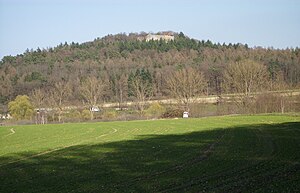
Friedinger Schlossberg (view from the southwest, taken south of the new development area Vor dem Dorf , 2014) |
||
| height | 547.2 m above sea level NHN | |
| location | Baden-Wuerttemberg , Germany | |
| Mountains | Hegau | |
| Dominance | 4.8 km → Homburg | |
| Coordinates | 47 ° 47 '4 " N , 8 ° 53' 15" E | |
|
|
||
| Type | Mountain cone | |
| rock | Nagelfluh , sandstones of the upper sea molasse | |
| Age of the rock | Tertiary , minimum ice age | |
The Friedinger Schlossberg is a mountain in Hegau on the boundary of the Singen district of Friedingen . It is centrally located in the district of Konstanz , around seven kilometers northwest of the Untersee , a part of Lake Constance whose mean water level is 547.2 m above sea level. Towering above sea level by around 150 m. This makes it the highest point in a chain of mountains and hills that together divide the Hegau lowlands into a northern and a southern basin. This ridge consists mainly of the Upper Sea Molasse , which forms the oldest rocky underground of the present-day area of the city of Singen and contains mussels, snails and shark teeth in coarse sand layers. On the northeast edge of the neighboring Buchberg these layers are exposed in a disused quarry. If you choose the steep, direct route to the summit on the Schlossberg over the north-western ridge, you will find yourself at 520 m above sea level. NHN also here on these coarse sandy layers. On the northern slope, on the other hand, you can see the gray-green fine-grained glauconite sands belonging to the Upper Sea Molasse , some of which also belong to the upper sea molasse , when you climb the edge of the old path, which has dug itself deeply as Hohlgasse over the centuries , coming from the so-called infirmary , referred to on maps as the leper house lying broken on the way and there from a height of 500 m above sea level. NN up to 510 m above sea level NN queue. If you choose the branching path here until you reach a level surface after approx. 100 m, the sand slate is also exposed. There is also a small cave here , in which the mountain population sought protection if necessary. From a height of 540 m above sea level. NHN the Obere Meeresmolasse is covered by Nagelfluh , which form the actual summit of the mountain and is occupied by the castle . This rock, which is reminiscent of coarse concrete , is mainly composed of alpine rocks such as flysch sandstone, crystalline rock and dolomite stone and was relocated here from the glaciers in the Mind Ice Age .
There are two residential spaces belonging to Friedingen on Friedingen's local mountain . These are the castle courtyard on the southern slope and, enthroned on the mountain peak, Hohenfriedingen Castle , which is the only hilltop castle in the German part of the Hegau that is still habitable and the landmark of Friedingen that can be seen from afar .
Because of the mild climate due to the proximity to Lake Constance and the exposed location, the sunny south and south-east facing mountain slopes were used for viticulture until the 20th century and a long time before that , which was given up with the ban on planting American grape varieties in 1929. Today the former vineyards are mainly meadows that are kept short by grazing, with scattered trees, groups of trees and bushes that provide shade. The north-facing mountain slopes, on the other hand, are covered with forest .
Landscape protection area
As early as May 9, 1957, the Friedinger Schlossberg and the neighboring Jöhlisberg with an area of 386.3 hectares under the name Schlossberg Friedingen (protected area number 3.35) were established in the districts of the communities Friedingen in the district of Konstanz and Steißlingen in the district of Stockach by the then regional council of South Baden . 007) placed under landscape protection.
Web links
Sources and literature
- Matthias Geyer: Volcanoes in Hegau . Land surveying office Baden-Württemberg, ISBN 3-89021-719-2 .
- Herbert Berner (Hrsg.): Singen city history . Volume 1. Foster mother of Hegaus
- State Office for Geology, Raw Materials and Mining (LGRB) in the Freiburg Regional Council
- State Office for the Environment, Measurements and Nature Conservation Baden-Württemberg
- MA König: Kumm etz gommer z´lieht, contributions to Friedinger history , 1990, ISBN 3-927414-01-8 .
Individual evidence
- ↑ Map services of the Federal Agency for Nature Conservation ( information )
- ↑ Hubenschmid et al .: Kumm etz gommer z'lieht - Contributions to Friedinger history: 900 years Friedingen 1090-1990 . Hohentwiel Verlag, 1990.
- ↑ Profile of the landscape protection area Schlossberg Friedingen

