Göhl (river)
| Göhl | ||
|
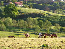
The Göhl near Strabeek in the municipality of Valkenburg aan de Geul, Netherlands. |
||
| Data | ||
| location | Belgium , Netherlands | |
| River system | Rhine | |
| Drain over | Meuse → Hollands Diep → North Sea | |
| River basin district | Meuse | |
| muzzle | In the Maas near Meerssen coordinates: 50 ° 53 ′ 49 " N , 5 ° 43 ′ 4" E 50 ° 53 ′ 49 " N , 5 ° 43 ′ 4" E
|
|
| length | 58 km | |
| Drain |
MQ |
1.5 m³ / s |
| Left tributaries | Gulp | |
| Right tributaries | Senserbach | |
The Göhl ( Dutch Geul , French Gueule ) is a river in Belgium and the Netherlands . The origin of the name Göhl is the Germanic word Galia , which means "narrow, winding river".
geography
The Göhl rises on Belgian territory on the border with Germany near Aachen , in Eynatten - Lichtenbusch , after about 20 km it crosses the border with the Netherlands and flows into the Meuse near the hamlet of Voulwames ( Meerssen ) north of Maastricht . The total length is 58 km, the difference in altitude between the source and the mouth about 250 m.
The largest places crossed are Kelmis and Plombières (Belgium) as well as Gulpen , Valkenburg and Meerssen.
history
From the 14th to the beginning of the 20th century, lead and zinc ore deposits were exploited in the Göhl valley near Kelmis (dialect for Galmei ) and Plombières (German: Bleiberg).
environment
flora
The unique Galmeiflora can be found on the heavy metal-containing soils in the Göhl Valley .
Water quality
Due to the former mining, the sediment of the Göhl in particular is heavily polluted with heavy metals and makes the largest single contribution to the pollution of the Meuse with lead (10%), zinc (8%) and cadmium (5%) below Maastricht. Furthermore, uncleaned wastewater from Belgium causes a high level of bacteria, nitrates and phosphates. Therefore bathing in the river is not officially allowed.
Sights and buildings
A well-known attraction was the old Hammerbrücke , a two-story railway viaduct over the Göhl valley on Belgian territory between Hauset and Hergenrath . It was destroyed in World War II and later replaced by a new bridge. A modern bridge that can be used by high-speed trains was put into operation in 1999.
A few kilometers downstream, at Moresnet, with a length of 1153 m and 22 fields with standard support widths of 49 m and a maximum height of 52 m, Belgium's longest railway bridge, the Göhl valley viaduct, rises up .
economy
In the area to the right and left of the Göhl, between Epen ( Gulpen-Wittem ) and Valkenburg, you will find one of the best-developed tourist areas in the Netherlands, the Mergelland , also known as Heuvelland.
Web links
- The history of the Hammerbrücke In: vonderruhren.de
- www. Grenzrouten.eu/pdf/3_-_Bleyberg.pdf (PDF file; 305 kB)
Individual evidence
- ↑ http ://www. Grenzrouten.eu/pdf/3_-_Bleyberg.pdf
- ↑ Henk Leenaers: The dispersal of metal mining wastes in the catchment of the river Geul (Belgium - The Netherlands). Dissertation, University of Utrecht 1989. Archive link ( Memento of the original dated December 7, 2007 in the Internet Archive ) Info: The archive link was inserted automatically and has not yet been checked. Please check the original and archive link according to the instructions and then remove this notice.
- ↑ Roer en Overmaas: Zwemmen in Geul en Gulp verboden archive link ( Memento of the original from December 21, 2015 in the Internet Archive ) Info: The archive link was automatically inserted and not yet checked. Please check the original and archive link according to the instructions and then remove this notice.


